Saint-Louis
Marie-Galante - 2 540 Hab.
Saint-Louis: Passionately Natural
The fortunes of Saint-Louis have always been closely linked with those of the two other communes of Marie-Galante, Grand-Bourg and Capesterre, and its history has much in common with that of the island as a whole: Amerindian occupation, the advent of the sugar economy, and many conflicts between the French and the British. However, over the centuries, Saint-Louis, with its distinct geography, has forged an identity all its own. The area was occupied by the Huecoid peoples, who came here from South America (Andes mountains) approximately 500 years B.C.E. These were followed by the Caribs, who settled primarily on the Plateau des Coqs (“Rooster Plateau”) and Anse du Coq (“Rooster Cove”), where they subsisted on fishing and slash-and-burn agriculture, growing cotton and manioc.
On November 3, 1493, after a voyage of 21 days from El Hierro (Canary Islands), Christopher Columbus landed on Dominica, continuing on the same day to the island the Caribs knew as Aichi, which he christened “Maria Galanda” (Marie-Galante), after his flagship. Following exploratory forays along the leeward coast in the area of Folle Anse, Columbus deemed the island too arid and lacking in fresh water to be of interest and soon departed.
The first Frenchmen arrived in November of 1648, dispatched by Guadeloupe Governor Charles Houël. Approximately fifty in number, they landed in a small, sheltered bay in the vicinity of present-day Vieux-Fort, northeast of where the town of Saint-Louis is currently located. This site was selected not only because of its freshwater lake, surrounded by mangrove swamps, but also because it directly faces the larger island of Guadeloupe. These early colonists chose a headland extending into the bay for their encampment, which consisted of modest huts inside an enclosure of timber rounds planted firmly in the ground, an arrangement they referred to as a fort. After a period of peaceful cohabitation, the colonists began encountering resistance from the indigenous Caribs, who invaded from Dominica in 1653. In reprisal for rapes and robberies committed in their villages, the Caribs massacred the entire population of colonists, mounting their heads on spikes. The site where this occurred is today called Massacre.
The conflict between the Caribs and the colonists lasted until 1660, when a peace treaty was signed in Basse-Terre. The main crops initially grown on the island were cotton, tobacco, and indigo.
In the late 17th century, sugar cane was introduced to Marie-Galante, followed shortly thereafter by the arrival of the first African slaves, who were brought here to work the plantations. Beginning in 1676, the French were attacked several times by the Dutch, and then by the British, with whom the French waged many battles over the course of more than a century (1692 - 1816). The parish of Saint-Louis received its first chapel in 1706.
Slavery was abolished in 1794 (initial abolition), but was reinstated in 1802. The sugar industry continued to grow, with the establishment of several sugar plantations here (Mayoumbé in 1825, Grand Bassin in 1827). The mill of the Grand Pierre Plantation (late 18th century) was the last to survive, finally ceasing operations in 1941.
In 1843, an earthquake hit the island, destroying Vieux-Fort. With this, local authorities relocated to the area around the Bay of Saint-Louis, and the town developed in tandem with the sugar industry. Slave revolts and abolitionist activities finally achieved their goal in 1848, with the definitive abolition of slavery. In 1864, the Desmarais refinery was built, closing its doors 14 years later in 1878. In 1865, the island was struck by a hurricane, followed by a cholera epidemic, resulting in many deaths. Other hurricanes have hit the island, including that of 1928, which led during the 1930s to the reconstruction of many buildings by Ali Tur, architect dispatched to the colonies by the French government.
In 1994, Marie-Galante signed a regional development charter. The three communes making up the Marie-Galante region committed to a program of developing local industry and protecting the island’s ecological heritage. Marie-Galante is now on the road to becoming a “green region” and Saint-Louis has every intention of playing a major role in realizing this new destiny.
Supported by a wealth of natural attractions, the commune of Saint-Louis, population 2,650, has embraced eco-tourism, promoting environmentally responsible behaviors across its 56.28-square-kilometer area. In partnership with the Amicale Ecolambda organization, it has designated the northeastern part of the island as a protected area. The coastline, in particular, is recognized as being environmentally and historically important, and has been the focus of careful preservation efforts. Tourist accommodations (multi-guest lodgings and bungalows) are kept to a small scale throughout the commune, and many eco-tourism activities are being developed not only on the coast, but also inland, where the area’s agricultural heritage is showcased. In August of each year, Saint-Louis celebrates its cattle-raising and sugar-cane-growing traditions at the “Fête de la Charrette” (“Cart Festival”).
Well known Saint-Louisans include world-renowned musician Camille Soprann and Maurice Barbotin (aka Zagaya), former parish priest who published a number of works on Marie-Galante and its mills, boroughs, and communes.
Tour of Saint-Louis
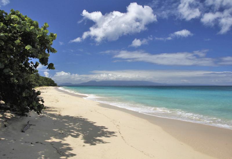
Mother Nature has been especially generous with this area, bestowing on it a variety of landscapes. The northern coast, facing the island of Grande-Terre, is characterized by high cliffs. The northern quarter is separated from the rest of the island by a fault scarp known as “La Barre.” To the west, beaches and mangrove swamps line the ocean shore. The rivers of Saint-Louis and Vieux-Fort, originating in the island’s center, traverse the plateau to empty themselves in the sea here. From its long, white-sand beaches and small coves, to its bucolic back-country, forests, cane fields, and mangrove swamps, Saint-Louis has much to offer nature-lovers.
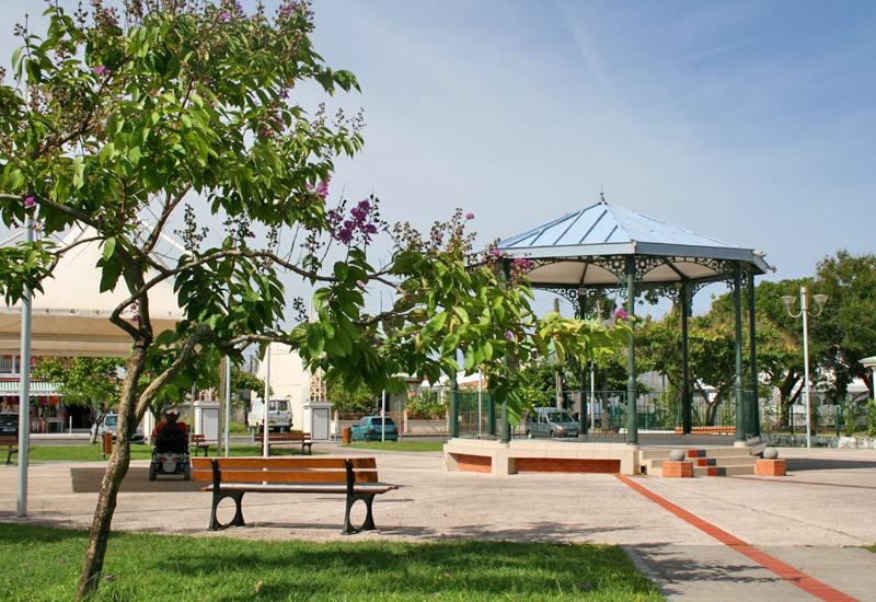
The town is a very pleasant place to stroll. Stop to admire the Town Hall with its tower—resembling that of a mosque—designed by Ali Tur. A cross commemorates the abolition of slavery (1849). Nearby stands the War Memorial, depicting a French World War I solider in his blue uniform. The landing dock is flanked on both sides by a long, fine-sand beach wide open to the sea. Many sailboats and pleasure boats anchor here. On any given day, young members of the water sports club may be seen busying themselves around their kayaks while fishermen prepare for their next runs. The town itself features a few lovely wooden traditional houses. Take Rue Raphaël Jerpan, one the town’s main thoroughfares, past Camille Soprann Square, an important gathering place, to the small chapel, a place of offering and reflection. Across from here stands the monument to Louis Delgrès, who fought in 1802 against the reinstitution of slavery. Enjoy a panoramic view from the old Desmarais site.
Take Departmental Highway D205 toward Vieux-Fort. The square in front of the church, named for Father Barbotin, former parish priest, features a crucifix and a Sailors’ Monument. Follow the coast past beautiful beaches at Mays and Moustique coves. Leaving D 205, continue along the coast, where you will soon come to the small, pleasant beach of Anse Canot, followed by another beach at Vieux-Fort, a popular mooring place featuring a view of the island of the same name. The current hamlet of Vieux-Fort marks the site where the colonists dispatched by Governor Charles Houël settled in 1648. Pleasant paddle-boat and kayak outings are available on the river that passes through the mangrove swamp.
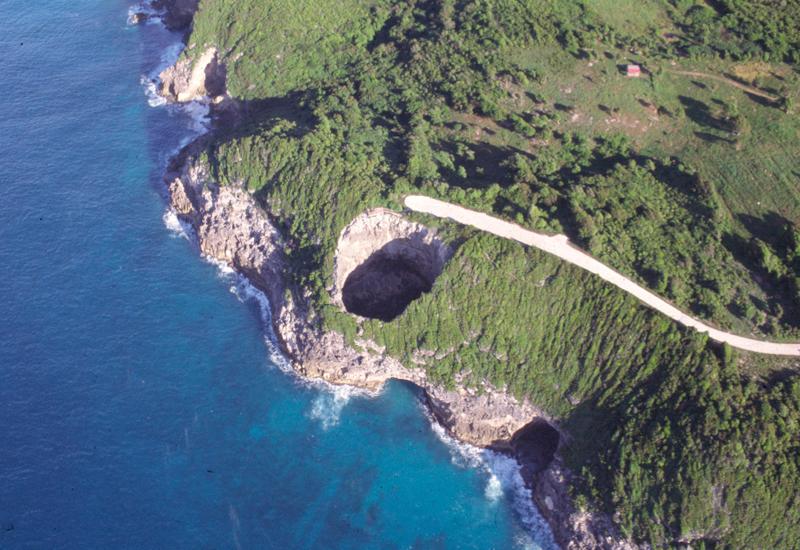
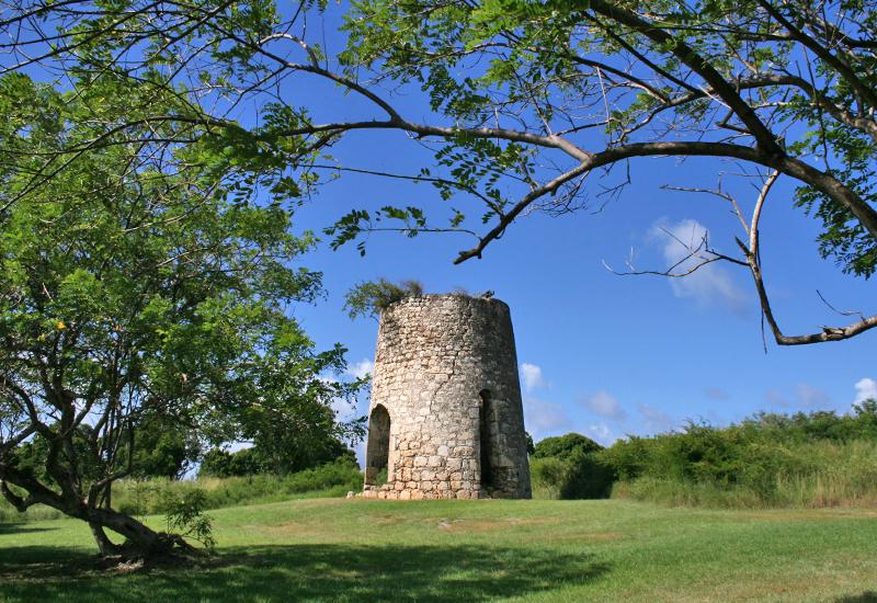
The scalloped eastern shoreline down to Pointe Ménard is characterized by cliffs rising over 100 meters high, alternating with a few low, sandy coves: Anse Bois d’Inde (“Indian Bay Tree Cove”), Anse Chapelle (“Chapel Cove”), and Anse Coudrier (“Hazelnut Cove”). Continuing along the coast, enjoy a view of the nicely restored Ménard Mill. In two kilometers, a trail on the left can be taken to Gueule Grand Gouffre, a massive hole in the rocky cliff (approximately thirty meters in circumference) formed by wave action and erosion. Continue eastward toward Caye Plate (“Flat Key”). Sainte-Thérèse Chapel may be accessed via a small road on the right. Anse du Coq (“Rooster Cove”) trail offers a sensational hike to a small cove of the same name tucked between the cliffs where Amerindians once lived. Caye Plate is a rocky outcropping very popular for line fishing. The trail from Caye Plate to Anse Piton (“Pinnacle Cove”) features stunning views. The cliffs are formed by crashing waves whose violence is unmitigated by offshore reefs.
From Pointe Cavale (“Escape Point”) and Anse Chapelle, which may be reached via a small road, enjoy a spectacular view of Frégate Rock and Pointe Saragot. It is possible to distinguish the displacement of the Saragot cliffs that occurred during the major earthquake of February 1843. Return to Departmental Highway D205, on the right, where a wide pool of water known as Grand Bassin may be seen on the left, along with Grand Bassin Plantation, whose old sugar refinery has been converted into a private house. Less then two kilometers away, Mayoumbé Mill stands as the last vestige of the sugar plantation established here in 1825.
Take Departmental Highway D201 toward Grelin. Just before arriving at the hamlet, visitors will see a small road on the right that leads to Fréchy. Carts loaded with freshly cut cane once traveled this road to the Dorot sugar mill-distillery. Note Grelin primary school, the work of architect Ali Tur. From behind the school there is a beautiful view. Grelin is also home to the Maison de l'Indigo (“House of Indigo”). Past the hamlet of Bois Rouge (“Red Wood”), take the small road to Grand Pierre Mill. Continue on D 201 toward Saint-Louis for one kilometer before turning left to Découverte (“Discovery”) and Les Sources (“The Springs”). Stop at a lookout point to enjoy the view across the coastal plain of Folle Anse, Basse-Terre and the Saintes islands. A hiking trail through a labyrinth of deep ravines leads to Les Sources and the peaceful Saint-Louis River. Return to Saint-Louis in time to enjoy a beautiful sunset over the ocean. Chemin Bleu tourist maps of Guadeloupe and city street maps are available at the Office of Tourism.

-
Sightseeing

- South Basse-Terre: Thrilling Sensations in a Tropical Forest Setting
- Côte-sous-le-vent: Artisanal Craftsmanship and Spectacular Diving
- North Basse-Terre: Glimmers of Sugar Cane and Marine Breezes
- North Grande-Terre: Stunning Landscapes and Cane Traditions
- East Grande-Terre: Thrilling Emotions on Land and Sea
- West Grande-Terre: Colors, Flavors, and a Glorious Past
- Les Saintes: Marine Breezes and Sweet Relaxation
- Marie-Galante: Non-Stop Charm in the Land of Sugar
- La Désirade: Untouched Landscapes, Shared Emotions
-
Tourist
-
Communes

- Les Abymes
- Anse-Bertrand
- Baie-Mahault
- Baillif
- Basse-Terre
- Bouillante
- Capesterre-Belle-Eau
- Capesterre-de-Marie-Galante
- Deshaies
- La Désirade
- Le Gosier
- Gourbeyre
- Goyave
- Grand-Bourg
- Lamentin
- Morne-à-l'Eau
- Le Moule
- Petit-Bourg
- Petit-Canal
- Pointe-à-Pitre
- Pointe-Noire
- Port-Louis
- Saint-Claude
- Sainte-Anne
- Sainte-Rose
- Saint-François
- Saint-Louis
- Terre-de-Bas
- Terre-de-Haut
- Trois-Rivières
- Vieux-Fort
- Vieux-Habitants
Downloadable
-
See all places

- “La Renaissance” movie theater - Pointe-à-Pitre
- 1st and 2nd Carbet Waterfalls - Capesterre Belle-Eau
- 3rd Carbet Waterfall - Capesterre Belle-Eau
- 5 February 1967, Square - Petit-Canal
- 9 August 1882 Square - Terre-de-Bas
- Acomat Falls - Pointe-Noire
- Acomat Point - Trois-Rivières
- Adventitious Church of Vieux-Habitants - Vieux-Habitants
- Airfield - Saint-François
- AIslands Cove - Sainte-Rose
- Alexina Garden - Le Gosier
- Allée de la Liberté - Bouillante
- Allée Dumanoir - Capesterre Belle Eau
- Allée Dumanoir Recreational Area - Capesterre Belle-Eau
- Almond Tree Beach - Sainte-Rose
- Amédée Detreaux Velodrome - Baie-Mahault
- Amédée Fengarol Primary School - Capesterre Belle-Eau
- Amerindian Garden of the Edgar Clerc Museum - Le Moule
- Amerindian Heritage - Baillif
- Ancien monastère Saint-Antoine - Basse-Terre
- Anse à Sable Beach - Bouillante
- Anse Colas - Anse-Bertrand
- Anse Crawen - Terre-de-Haut
- Anse de Pigeon - Bouillante
- Anse du Fond Curé - Terre-de-Haut
- Anse du Souffleur beach - Port-Louis
- Anse Duché Beach - Bouillante
- Anse Dupuy - Vieux-Fort
- Anse Feuillard Cove - Capesterre de Marie-Galante
- Anse Laborde Beach - Anse-Bertrand
- Anse-Bertrand - 5 276 Hab.
- Aquaculture Park - Pointe-Noire
- Aquarium - Le Gosier
- Arboretum - Trois-Rivières
- Assainissement district - Pointe-à-Pitre
- Audoin River - Le Moule
- Babin Beach - Morne-A-l'Eau
- Back Cove - Terre-de-Bas
- Bagasse-Coal Plant - Le Moule
- Baie de Blachon - Lamentin
- Baie-Mahault - 31 069 Hab.
- Baillif - 5 801 Hab.
- Balloon Bridge - Sainte-Anne
- Banana Wood Waterfall - Lamentin
- Basse-Terre - 11 049 Hab.
- Battery Point - Deshaies
- Beach of the Other Side - Le Moule
- Beaufond Windmill - Anse-Bertrand
- Beauplaisir Windmill - Port-Louis
- Beauport Guadeloupe - Port-Louis
- Beautiran Path - Petit-Canal
- Beautiran Site - Petit-Canal
- Bébian school - Pointe-à-Pitre
- Begging Mayor Square - La Désirade
- Belin windmill - Port-Louis
- Belmont Plantation Slave Dungeon - Trois-Rivières
- Bernard Refinery - Capesterre de Marie-Galante
- Bétin plantation - Port-Louis
- Bettino Lara Media Library - Basse-Terre
- Beuthier windmill - Port-Louis
- Bézard windmill - Capesterre de Marie-Galante
- Bielle Distillery - Grand-Bourg
- Big Basin - Saint-Louis
- Big Hill - Deshaies
- Big Hole Pond - Terre-de-Bas
- Big Mouth Chasm - Saint-Louis
- Big Pond - Capesterre Belle Eau - Capesterre Belle-Eau
- Big Sand Beach - Sainte-Anne
- Bik-Kontakaz - Sainte-Anne
- Bisardy Plantation - Gourbeyre
- Bishopric - Basse-Terre
- Blackberry Bush Cove - Terre-de-Bas
- Blessed Savior Cove - Capesterre Belle-Eau
- Blondeau Plantation - Vieux-Fort
- Blonzac Aquatic Garden - Goyave
- Blower Beach - La Désirade
- Blue Pool - Gourbeyre
- Boat Cove - Saint-François
- Boat Cove - Bouillante
- Boat Cove - Vieux-Habitants
- Bois-Debout Plantation - Capesterre Belle-Eau
- Bologne Distillery - Basse-Terre
- Botanical Garden - Basse-Terre
- Botanical Garden - Deshaies
- Bouillante - 7 528 Hab.
- Bras du Fort Falls - Goyave
- Budan Windmill - Anse-Bertrand
- Bust of Augustin Gourbeyre - Gourbeyre
- Bust of Delgrès - Saint-François
- Bust of Delgrès - Deshaies
- Bust of Delgrès - Goyave
- Bust of Delgrès - Vieux-Habitants
- Bust of Félix Eboué - Pointe-à-Pitre
- Bust of Félix Eboué - Sainte-Rose
- Bust of General Frébault - Pointe-à-Pitre
- Bust of Jean Louis - Goyave
- Bust of Louis Delgrès - Pointe-Noire
- Bust of Lucien Bernier - Saint-François
- Bust of Victor Schœlcher - Morne-A-l'Eau
- Buste de Félix Eboué - Morne-A-l'Eau
- Cadoue Windmill - Anse-Bertrand
- Calvary Nature Park - Le Gosier
- Camille Soprann Square - Saint-Louis
- Camp Jacob - Saint-Claude
- Capès-Dolé Bottling Plant - Gourbeyre
- Capesterre Belle-Eau - 19 315 Hab.
- Capesterre de Marie-Galante - 3 355 Hab.
- Caraïbes Mountains - Vieux-Fort
- Caravelle Beach - Sainte-Anne
- Caravelle Surf Spot - Sainte-Anne
- Caribbean Beach - Pointe-Noire
- Caribbean Mountains - Gourbeyre
- Carmelite Square - Basse-Terre
- Carved Rock Archeological Park - Trois-Rivières
- Casino de Saint-François - Saint-François
- Cassava Factory - Sainte-Anne
- Cassava Factory - Petit-Bourg
- Cayenne Cemetery - Saint-François
- Cemetery - Morne-A-l'Eau
- Cemetery - Pointe-à-Pitre
- Cemetery Square - Le Moule
- Center for Embroidery and Textile Arts - Vieux-Fort
- Central Covered Market - Basse-Terre
- Central Market - Pointe-à-Pitre
- Champ d’Arbaud Parade Grounds - Basse-Terre
- Changy Hindu Temple - Capesterre Belle-Eau
- Chapel Beach - Anse-Bertrand
- Chapel Our Lady of Charity - Le Moule
- Chapelle Notre Dame de Guadeloupe - Saint-Claude
- Chapelle Notre Dame du Phare - La Désirade
- Chapelles - Port-Louis
- Chapp House - Basse-Terre
- Chevalier de Saint-Georges Square - Basse-Terre
- Christ the King Church at Les Mangles - Petit-Canal
- Church of Notre Dame du Bon Port - Petit-Bourg
- Church of Our Lady of Good Help - Port-Louis
- Church of Saint Phillip and Saint John - Petit-Canal
- Church of Saint-Louis - Bouillante
- Church of Sainte-Anne - Goyave
- Church of Sainte-Thérèse de l'Enfant Jésus - Petit-Bourg
- Church of St. John the Baptist - Le Moule
- Church of St. John the Baptist - Baie-Mahault
- Church of St. Peter and St. Paul - Deshaies
- Church of the Immaculate Conception - Les Abymes
- Church of the Immaculate Conception - Grand-Bourg
- Church Square - Saint-François
- Church Square - Saint-Louis
- Cicéron Alley - Basse-Terre
- Cimetière des Indiens - Saint-François
- Ciné-Théâtre - Lamentin
- City Hall - Les Abymes
- City Hall - Basse-Terre
- City Hall - Vieux-Habitants
- City Pavilion - Pointe-à-Pitre
- Claire Fontaine Plantation - Baillif
- Cliff Trace - Anse-Bertrand
- Cliffs - Vieux-Fort
- Cluny Beach - Sainte-Rose
- Cœur de Bouillante - Bouillante
- Coffee Museum - Vieux-Habitants
- Colo Pool - Petit-Bourg
- Colonial House - Le Moule
- Column and Bust of Marianne - Bouillante
- Commemorative plaque in homage to Justin Catayée - Pointe-à-Pitre
- Courthouse - Basse-Terre
- Crab House - Le Moule
- Crawfish Cascade - Petit-Bourg
- Crazy Cove Beach - Grand-Bourg
- Damencourt Nature Park - Le Moule
- Damoiseau Distillery - Le Moule
- Dampierre windmill - Le Gosier
- Datcha Beach - Le Gosier
- Delgrès Stele - Morne-A-l'Eau
- Departmental Residence - Le Gosier
- Descamps House, Birmingham Plantation - Baie-Mahault
- Deshaies - 4 215 Hab.
- Deshaies Cove - Deshaies
- Deshaies Diving - Deshaies
- Desmarais Distillery - Saint-Claude
- Dévarieux windmill - Petit-Canal
- Deville-Maisoncelle Path - Petit-Canal
- Diavet and Bwé ponds - Le Gosier
- Distillerie Bellevue - Capesterre de Marie-Galante
- Diving - Bouillante
- Dolé Public Pool - Gourbeyre
- Domaine de la Lise - Bouillante
- Domaine de St-Paul - Sainte-Anne
- Du Mont Cove - Le Gosier
- Duval Site - Petit-Canal
- Eco-museum of Guadeloupe - Sainte-Rose
- Eco-Touristic Park of Trois-Pointes - Vieux-Fort
- Edgar Clerc Museum - Le Moule
- Eiffel Bridge - Pointe-Noire
- Eiffel-style Bridges - Goyave - Goyave
- Eloi Germain Interpretive Garden - Terre-de-Bas
- Escape Hill - Sainte-Anne
- Escaped Slave Memorial - Sainte-Anne
- Espace Thermo-Ludique René Toribio - Lamentin
- Espace Wizosky - Le Moule
- Fanfan Beach - La Désirade
- Father Labat Tower - Baillif
- Fatima Chapel - Le Moule
- Félix Eboué Square - Capesterre de Marie-Galante
- Ferry Battery - Deshaies
- Ferry Cove - Deshaies
- Feuillère Beach - Capesterre de Marie-Galante
- Fidelin Pond - Les Abymes
- Fiesque Duchesne Stadium - Baie-Mahault
- Fifi Beach - La Désirade
- Fig Tree Beach - Terre-de-Haut
- Fishing and Pleasure Boat Port - Sainte-Rose
- Fishing and Pleasure Boat Port - Sainte-Rose
- Fishing Port - Saint-François
- Fishing Port - Le Moule
- Fishing Port - Deshaies
- Folle-Anse Cargo Port - Grand-Bourg
- Fontaine Adolphine - Saint-Claude
- Footbridge of the Two Banks - Le Moule
- Former Cotton Mill - La Désirade
- Former Dorot Distillery - Saint-Louis
- Former Duval Refinery - Petit-Canal
- Former Fidelin Pottery Works - Terre-de-Bas
- Former Grosse Montagne Sugar Plant - Lamentin
- Former health care center and maternity hospital - Port-Louis
- Former Law Courts - Port-Louis
- Former Leper Colony - La Désirade
- Former Marquisat Factory - Capesterre Belle-Eau
- Former Power Plant: La Friche - Baie-Mahault
- Former Prison - Petit-Canal
- Former Prison - Goyave
- Former Prison - Anse-Bertrand
- Former Rex movie theater - Port-Louis - Port Louis
- Former Saint-Jacques plantation - Saint-François
- Former Weather Station - La Désirade
- Fort Fleur d'Epée - Le Gosier
- Fort l'Olive - Vieux-Fort
- Fort Louis - Le Gosier
- Fort Louis Delgrès - Basse-Terre
- Fort Napoleon - Terre-de-Haut
- Fortune Islet - Goyave
- Fountain - Gourbeyre
- Fresque murale du lycée de Baimbridge - Les Abymes
- Gadet Lookout - Deshaies
- Galion Falls - Saint-Claude
- Galion Gorges - Saint-Claude
- Gardel Factory - Le Moule
- Gaschet Ravine - Petit-Canal
- Gates of Hell - Le Moule
- Gates of Hell - Anse-Bertrand
- Gédéon-Bambou park - Morne-A-L'Eau
- General Council Building - Basse-Terre
- Gertrude Square - Petit-Bourg
- Gerty Archimède Museum - Basse-Terre
- Gerville-Réache Secondary School - Basse-Terre
- Getz Plantation - Vieux-Habitants
- Gilles Floro Culture House - Gourbeyre
- Girard windmill - Petit-Canal
- Giratoire “Les amarreuses de Jabrun” - Baie-Mahault
- Gissac windmill - Sainte-Anne
- Godet windmill - Petit-Canal
- Good Mother Factory - Sainte-Rose
- Gourbeyre - 7 986 Hab.
- Gourd Cove Beach - Saint-François
- Goyave - 7 761 Hab.
- Grand Cove Beach - Deshaies
- Grand Cul-de-Sac Marin Bay - Sainte-Rose
- Grand Cul-de-Sac Marin Natural Preserve - Baie-Mahault
- Grand Pierre windmill - Saint-Louis
- Grand-Anse Beach - Terre-de-Bas
- Grand-Bourg - 5 409 Hab.
- Grand-Bourg Beach - Grand-Bourg
- Grand-Point Battery - Trois-Rivières
- Grande Anse Sugar Refinery - Grand-Bourg
- Grande Rivière à Goyaves - Lamentin
- Grande Vigie Point - Anse-Bertrand
- Grande-Anse Battery - Trois-Rivières
- Grandfond Windmill - Anse-Bertrand
- Grands Fonds - Le Gosier
- Grands Fonds - Sainte-Anne
- Grands Fonds - Le Moule
- Grands Fonds - Les Abymes
- Great Cove Beach - Trois-Rivières
- Greenery Point - Le Gosier
- Guyonneau Plantation - Deshaies
- Habitation Desmarets - Basse-Terre
- Habitation La Mahaudière - Anse-Bertrand
- Harbor Terminal - Saint-François
- Helleux Surf Spot - Sainte-Anne
- Henry Sidambarom Stela - Capesterre Belle-Eau
- Heritage House - Basse-Terre
- Hiking Trails - Gourbeyre
- Hiking Trails - La Désirade
- Hiking Trails - Terre-de-Bas
- Hiking Trails - Pointe-Noire
- Hindu temple - Les Abymes
- Hindu Temple of Gaschet - Port-Louis
- Hot baths of Matouba - Saint-Claude
- House of Bananas - Trois-Rivières
- House of Cacao - Pointe-Noire
- House of the Elders - Basse-Terre
- Hummingbird Point - La Désirade
- Ilet Boissard - Pointe-à-Pitre
- Ilet Caret - Sainte-Rose
- Ilets de Carénage, Ilet Blanc, Ilet la Biche - Sainte-Rose
- Indian Memorial - Saint-François
- Information Office and Bust of Louis Delgrès - Gourbeyre
- International Golf Course - Saint-François
- Isle of the Goats - Terre-de-Haut
- Jardin de la Rencontre - Capesterre Belle-Eau
- Jérôme Cléry Municipal Auditorium - Basse-Terre
- Jolan Woods Beach - Sainte-Anne
- Karukera Rum Distillery - Capesterre Belle-Eau
- Karuptures – Totem, Work of Edgar Negret - Lamentin
- Karuptures, Lumi-Naissance - Lamentin
- Karuptures, Madonna and Child, work of Leopoldo Maler - Lamentin
- Karuptures, Physiochromie du Lamentin, work of Carlos Cruz Diez. - Lamentin
- Karuptures, Tribute to the abolition of human slavery, work of Erik Dietman - Lamentin
- Kreol West Indies - Grand-Bourg
- Kreol West Indies Museum Space - Saint-François
- L’Herminier House - Pointe-à-Pitre
- L’il Cove Beach - Pointe-Noire
- La Coulisse - Trois-Rivières
- La Darse - Pointe-à-Pitre
- La Désirade - 1 549 Hab.
- La Grivelière Plantation - Vieux-Habitants
- La Lézarde Falls - Petit-Bourg
- La Lézarde River - Petit-Bourg
- La Mahaudière Windmill - Anse-Bertrand
- La Marianne - Pointe-Noire
- La Pastorale House - Trois-Rivières
- La Ramée Plantation - Sainte-Rose
- La Rose Plantation - Goyave
- Ladder Cove - La Désirade
- Lagoon Beach - Saint-François
- Lake Gaschet - Port-Louis
- Lamentin - 16 313 Hab.
- Latchmansing temple - Shiva temple - Saint-François
- Laura Flessel Sports Complex - Petit-Bourg
- Le Chameau - Terre-de-Haut
- Le Gosier - 27 920 Hab.
- Le Gosier Islet - Le Gosier
- Le Moule - 22 404 Hab.
- Leeward Coast House - Vieux-Habitants
- Leroux Beach - Deshaies
- Les Abymes - 56 581 Hab.
- Letaye Dam - Le Moule
- Lethière Street - Sainte-Anne
- Lethière Traffic Circle - Sainte-Anne
- Liberty Square - Basse-Terre
- Lighthouse - Vieux-Fort
- Little Cove Beach - Capesterre de Marie-Galante
- Little River Beach - La Désirade
- Loiseau Plantation - Vieux-Habitants
- Louis Delgrès Stela - Saint-Claude
- Lovers’ Pool - Gourbeyre
- Lubeth windmilll - Petit-Canal
- Lycée Carnot - Pointe-à-Pitre
- Maison de la Forêt - Petit-Bourg
- Maison de la Mangrove - Les Abymes
- Maison Monnerville - Morne-A-l'Eau
- Maisons typiques - Anse-Bertrand
- Malendure Beach - Bouillante
- Mambia beach - Sainte-Rose
- Mamelles Zoological Park - Bouillante
- Man Réaux Mall - Pointe-à-Pitre
- Mangrove Swamp - Le Gosier
- Mangrove Swamps - Petit-Canal
- Mangrove Swamps - Saint-Louis
- Mangrove-la Ka - Port-Louis
- Manioc Factory - Deshaies
- Marigot Bay - Terre-de-Haut
- Marina - Saint-François
- Marina - Le Gosier
- Marina - Pointe-à-Pitre
- Marina traffic circle - Pointe-à-Pitre
- Marius Chipotel Square - Sainte-Anne
- Market - Sainte-Anne
- Market - Capesterre Belle-Eau
- Marquisat de Sainte-Marie Estate - Capesterre Belle-eau
- Marshes - Port-Louis
- Massabielle church - Pointe-à-Pitre
- Massif de la Madeleine - Trois-Rivières
- Matouba Factory - Saint-Claude
- Matouba Falls - Saint-Claude
- Maurice Cove - Petit-Canal
- Max Mathurin Stela - La Désirade
- Mayoumbé windmill - Saint-Louis
- Mays Cove - Saint-Louis
- Médiathèque Ernest J. Pépin - Lamentin
- Mémorial ACTe - Pointe-à-Pitre
- Mémorial aux victimes de 1925 - Petit-Canal
- Memorial to the First Day - Pointe-à-Pitre
- Memorial to the Sacrifice of Delgrès - Les Abymes
- Memorial to the victims of May 1967 - Pointe-à-Pitre
- Memorial to Victor Schoelcher - Vieux-Habitants
- Mémorial Victor Schœlcher - La Désirade
- Memorial Wall - Les Abymes
- Ménard windmill - Saint-Louis
- Michaux windmill - Petit-Canal
- Mills - Saint-François
- Moko Bridge - Lamentin
- Moko Bridge - Sainte-Rose
- Montal Beach - Le Moule
- Montebello Distillery - Petit-Bourg
- Monument aux morts - Anse-Bertrand
- Monument aux morts (“War Memorial”) - Lamentin
- Monument of the Eternal Flame to the Unknown Slave - Petit-Canal
- Monument to Christopher Columbus - Capesterre Belle-Eau
- Monument to Freedom - Petit-Canal
- Moreau Falls - Goyave
- Moreau Interpretive Trail - Goyave
- Morel Trace - Terre-de-Haut
- Morne Calvaire - Les Abymes
- Morne de la Mémoire - Les Abymes
- Morne-à-l'Eau - 17 504 Hab.
- Morne-Rouge School - Sainte-Rose
- Murat Plantation and Eco-Museum of Marie-Galante - Grand-Bourg
- Musée de la graine - Trois-Rivières
- Museum of Costumes and Traditions - Le Gosier
- Museum of Days Gone By - Petit-Canal
- National Theater - Basse-Terre
- Nature Park - Petit Canal
- Neg Mawon Stela - Petit-Bourg
- Néron Plantation - Le Moule
- Night Market - Saint-François
- Night Market - Sainte-Anne
- Night Market - Petit-Bourg
- Notre Dame du Mont-Carmel Church - Basse-Terre
- Notre Dame Sanctuary - Deshaies
- Notre-Dame de Guadeloupe Cathedral - Basse-Terre
- Novilos Courtyard - Basse-Terre
- Nozières Bridge - Saint-Claude
- Oceanfront - Basse-Terre
- Old Mill Trace - Petit-Canal
- Old Town Hall - Saint-Claude
- Olive Bay - Saint-François
- Olympe Victor Auguste Combes Giratoire - Lamentin
- Open-Air Theater - Lamentin
- Oratory - Goyave
- Ornithological site of Ravine Sable - Anse-Bertrand
- Osange Talis Gane Multimedia Library - Sainte-Anne
- Ouatibi Tibi Park - Le Moule
- Our Lady of Calvary Chapel - La Désirade
- Our Lady of Good Help Church - La Désirade
- Our Lady of Good Hope - Morne-A-l'Eau
- Our Lady of Jarry Chapel - Baie-Mahault
- Our Lady of the Assumption Church - Terre-de-Haut
- Our Lady of the Assumption Church - Pointe-Noire
- Our Lady of the Assumption Church - Trois-Rivières
- Palace of Culture Felix Proto - Les Abymes
- Palais d'Orléans (Prefecture Building) - Basse-Terre
- Paradise Pool - Capesterre Belle-Eau
- Paradoxe Croisières - Saint-François
- Parc de la Source - Bouillante
- Parc de la Verdure - Lamentin
- Parc National - Saint-Claude
- Paul Aubin windmill - Port-Louis
- Paul Lacavé Memorial - Capesterre Belle-Eau
- Paul Mado Multimedia Library - Baie-Mahault
- Paved Path Ravine - Le Gosier
- Pearl Beach - Deshaies
- Pebble Beach - La Désirade
- Pebble Cove - La Désirade
- Perrin Canal - Les Abymes
- Petit Carbet Plantation-Refinery - Trois-Rivières
- Petit Cul-de-Sac Marin - Petit-Bourg
- Petit-Bourg - 24 507 Hab.
- Petit-Canal - 8 262 Hab.
- Petit-Havre Beach - Le Gosier
- Petite Anse Cove - Terre-de-Bas
- Petite Terre - La Désirade
- Petite-Anse beach - Bouillante
- Pichon Square - Basse-Terre
- Pigeon Isles - Bouillante
- Place Camille Desmoulins - Pointe-à-Pitre
- Place de la Mairie - Bouillante
- Place de la Victoire - Pointe-à-Pitre
- Place Frédéric Jalton - Les Abymes
- Place Gerty Archimède - Morne-A-l'Eau
- Place Gourbeyre - Pointe-à-Pitre
- Plage de Grande-Anse - Terre-de-Haut
- Plage de l'Anse Canot - Saint-Louis
- Plage de la Porte d'Enfer - Anse-Bertrand
- Plage de Moustique - Saint-Louis
- Plaine de Grippon - Morne-A-l'Eau
- Plaisance windmill - Port-Louis
- Plantation Grand Café - Capesterre Belle-Eau
- Plate Point Trail - Anse-Bertrand
- Plateau du Palmiste - Gourbeyre
- Platform of Beron (Bonne Mère) - Sainte-Rose
- Point Bleu Soleil - Gourbeyre
- Point Helleux Beach - Sainte-Anne
- Pointe Allègre - Sainte-Rose
- Pointe des Châteaux - Saint-François
- Pointe-à-Pitre - 16 427 Hab.
- Pointe-Noire - 6 519 Hab.
- Poisson Distillery - Grand-Bourg
- Pôle Caraïbes Airport - Les Abymes
- Polishing block of Dindé - Sainte-Rose
- Pompierre Beach - Terre-de-Haut
- Pond Beach - Vieux-Habitants
- Pond Trace Hiking Trail - Capesterre Belle-Eau
- Ponds - Anse-Bertrand
- Pont de la rivière du Plessis - Baillif
- Port - Petit-Canal
- Port - Port-Louis
- Port - La Désirade
- Port - Capesterre de Marie-Galante
- Port - Grand-Bourg
- Port - Saint-Louis
- Port - Baie-Mahault
- Port de Vieux-Bourg - Morne-A-l'Eau
- Port Galbas - Sainte-Anne
- Port of Jarry - Baie-Mahault
- Port-Louis - 5 867 Hab.
- Pottery Kiln - Trois-Rivières
- Poyen windmill - Petit-Canal
- Presbytery - Port-Louis
- Primary School “Alice Delacroix“ - Petit Canal
- Public Park and Fountain - Trois-Rivières
- Pulling bull contests - Anse-Bertrand
- Pulling bull contests - district of Guéry - Anse-Bertrand
- Pulling Bulls - Baie-Mahault
- Punch Pond and Pirogue Factory - Grand-Bourg
- Rambouillet Cross - Port-Louis
- Raoul Georges Nicolo Media Library - Le Gosier
- Ravine Sable (Sand Ravine) - Anse-Bertrand
- Red Bridge - Deshaies
- Red Head - Terre-de-Haut
- Regional Council of Guadeloupe - Basse-Terre
- Rémy Nainsouta Center - Pointe-à-Pitre
- René Boisneuf Multimedia Library - Pointe-à-Pitre
- Réserve Cousteau - Bouillante
- Rifflet Beach - Deshaies
- Ring of Slavery - Pointe-à-Pitre
- Rivière de la Coulisse - Trois-Rivières
- Rocroy Beach - Vieux-Habitants
- Rodriguez Cove - Terre-de-Haut
- Rooster Cove - Saint-Louis
- Roseau Beach - Capesterre Belle-Eau
- Rotours Canal - Morne-A-l'Eau
- Roussel-Trianon Sugar Planation - Grand-Bourg
- Rue Achille-René Boisneuf - Pointe-à-Pitre
- Rue Frébault - Pointe-à-Pitre
- Rum Museum - Sainte-Rose
- Sailing Center - Goyave
- Saint Anne Church - Capesterre de Marie-Galante
- Saint Bernadette Church of Grands Fonds - Sainte-Anne
- Saint Denis Church - Anse-Bertrand
- Saint Dominic Church - Baillif
- Saint Hyacinth Church - Capesterre Belle-Eau
- Saint Rose of Lima Church - Sainte-Rose
- Saint-Albert Church - Vieux-Fort
- Saint-André church - Morne-A-l'Eau
- Saint-Augustin Church - Saint-Claude
- Saint-Charles Borromée Church - Gourbeyre
- Saint-Claude - 10 587 Hab.
- Saint-Felix Beach - Le Gosier
- Saint-François - 14 609 Hab.
- Saint-Jacques Racetrack - Anse-Bertrand
- Saint-John Perse Museum - Pointe-à-Pitre
- Saint-Joseph Church - Vieux-Habitants
- Saint-Joseph de Cluny Day School - Pointe-à-Pitre
- Saint-Louis - 2 540 Hab.
- Saint-Louis Beach - Saint-Louis
- Saint-Louis Church - Le Gosier
- Saint-Louis Plantation - Baillif
- Saint-Nicolas Church - Terre-de-Bas
- Saint-Pierre and Saint-Paul church - Pointe-à-Pitre
- Sainte-Anne - 25 037 Hab.
- Sainte-Anne Church - Sainte-Anne
- Sainte-Claire Beach - Goyave
- Sainte-Rose - Sainte-Rose
- Sainte-Trinité Church - Lamentin
- Saintes Bay - Terre-de-Haut
- Salabouelle Cove - Le Moule
- Saline Beach - Le Gosier
- Saltwork Beach - Le Gosier
- Salty Cove - Capesterre Belle-Eau
- Sans Fenêtre Windmill - Anse-Bertrand
- Sarrault Square - Petit-Bourg
- Schœlcher Museum - Pointe-à-Pitre
- Schœlcher Square - Sainte-Anne
- Sé la vi la ki pli bèl (“Life is Beautiful”) Sculpture - Basse-Terre
- Seashore - Pointe-Noire
- Seaside cemetery - Port-Louis
- Sens River Beach - Gourbeyre
- Sens River Marina - Gourbeyre
- Sentier de l'Acomat - Trois-Rivières
- Sentier Lavolvaine - Port-Louis
- Séo Pond - Sainte-Anne
- Séverin Estate - Sainte-Rose
- Shell House - Basse-Terre
- Shoreline Trail - Le Gosier
- Shrine of Our Lady of Tears - Pointe-Noire
- Silver Basin Port - Pointe-Noire
- Simaho Beach - Vieux-Habitants
- Simonière pond - Saint-François
- Site of the 1962 Boeing Jet Crash - Deshaies
- Slave Cemetery - Capesterre Belle-eau
- Slave Memorial - Saint-François
- Slave Steps - Petit-Canal
- Small Fort - Le Moule
- Social Hall - Lamentin
- Sofaïa Sulfur Springs - Sainte-Rose
- Sonis Cultural Center - Les Abymes
- Source de Poucet - Le Gosier
- Source de Thomas - Bouillante
- Source of the Rivière Rouge - Saint-Claude
- Sports Center - Le Gosier
- Spot de Damencourt - Le Moule
- Spot de La Bouelle - Le Moule
- Spot de La Chapelle - Anse-Bertrand
- Spot de La Station - Le Moule
- Square Christophe Colomb (Christopher Columbus Square) - Baie-Mahault
- Square Guy Cornély - Les Abymes
- Statue of Gandhi - Saint-François
- Statue of Joseph Ignace - Les Abymes
- Statue of Martin Luther King - Saint-François
- Statue of Nelson Mandela - Les Abymes
- Statue of the mulatto woman, “Solitude” - Les Abymes
- Statue of Vélo, the King of ka - Pointe-à-Pitre
- Sucrerie de Nogent - Sainte-Rose
- Sugar Cane Tradition - Baie-Mahault
- Sugar Loaf Mountain - Terre-de-Haut
- Sylvathèque - Gourbeyre
- Tabarin Cove Beach - Le Gosier
- Taliseronde Beach - Capesterre de Marie-Galante
- Tarare Cove - Saint-François
- Teddy Riner Square - Vieux-Habitants
- Terre-de-Bas - 1 097 Hab.
- Terre-de-Haut - 1 699 Hab.
- The Carénage district - Pointe-à-Pitre
- The district of “Grand-Baie“ - Le Gosier
- The Former Arsenal - Basse-Terre
- The former City Hall - Les Abymes
- The former Darboussier factory - Pointe-à-Pitre
- The former factory in Blanchet - Morne-à-l'Eau
- The former factory in Pointe-à-Retz - Morne à l'Eau
- The Galleries - Capesterre de Marie-Galante
- The Geothermal Plant - Bouillante
- The Law Courts - Pointe-à-Pitre
- The Mutual Insurance Building - Pointe-à-Pitre
- The New Courthouse - Pointe-à-Pitre
- The Observer - Deshaies
- The Old Municipal Jail - Bouillante
- The Old Town Hall - Bouillante
- The Pointe des Châteaux Cross - Saint-François
- The Port - Petit-Bourg
- The Port - Goyave
- The Rotunda - Saint-François
- The Sulfurer Volcano - Saint-Claude
- Three Bridges - Sainte-Anne
- Three Islands Beach - Grand-Bourg
- Three-Horn Falls - Sainte-Rose
- Tillet Beach - Deshaies
- Tourist House - Saint-Claude
- Town Beach - Sainte-Anne
- Town Hall - Sainte-Anne
- Town Hall - Morne-A-l'Eau
- Town Hall - Port-Louis
- Town Hall - Grand-Bourg
- Town Hall - Capesterre de Marie-Galante
- Town Hall - Petit-Bourg
- Town Hall - Sainte-Rose
- Town Hall - Lamentin
- Town Hall - Pointe-Noire
- Town Hall - Capesterre Belle-Eau
- Town Hall - Trois-Rivières
- Town Hall - Baillif
- Town Hall - Saint-Claude
- Town Hall - Baie-Mahault
- Town Hall - Petit-Canal
- Town Hall Square - Terre-de-Haut
- Town Hall Square - Petit-Bourg
- Tradewinds Beach - Le Moule
- Traditional Houses - Petit-Bourg
- Traditional Houses - Pointe-Noire
- Traditional Houses - Basse-Terre
- Trois-Rivières - 8 625 Hab.
- Typical houses - Port-Louis
- Typical houses - Pointe-à-Pitre
- Typical houses - Morne-à-l'Eau - Morne à l'Eau
- Valombreuse Gardens - Petit-Bourg
- Vanibel Estate - Vieux-Habitants
- Vernou Residential Quarter - Petit-Bourg
- Viard Beach - Petit-Bourg
- Viard River - Sainte-Rose
- Victor Schœlcher Column - Anse-Bertrand
- Victor Schœlcher Square - Grand-Bourg
- Victor Servan Soliman Nature Park - Petit-Bourg
- Vieux-Bourg church - Morne-A-l'Eau
- Vieux-Fort - 1 897 Hab.
- Vieux-Fort Beach - Saint-Louis
- Vieux-Habitants - 7 602 Hab.
- Volcanology and Seismology Laboratory - Gourbeyre
- Walking and Hiking - Bouillante
- War Memorial - Sainte-Anne
- War Memorial - Petit-Canal
- War Memorial - Port-Louis
- War memorial - Pointe-à-Pitre
- War Memorial - Les Abymes
- War Memorial - Saint-Louis
- War Memorial - Baie-Mahault
- War Memorial - Petit-Bourg
- War Memorial - Pointe-Noire
- War Memorial - Capesterre Belle-Eau
- War Memorial - Vieux-Habitants
- Water Cove - Saint-François
- Water Sports Center - Saint-François
- Water Sports Center - Sainte-Anne
- Water Sports Center - Sainte-Rose
- Waterfront - Sainte-Anne
- Waterfront - Baie-Mahault
- Waterfront Boulevard - Le Moule
- Wharf - Trois-Rivières
- White Grape Beach - Saint-François
- White Water Bridge - Le Moule
- Wind Farms - Capesterre de Marie-Galante
- Wind Turbines - La Désirade
- Wind Turbines - Terre-de-Bas
- Wonche Colonial House - Baie-Mahault
- World Trade Center Complex - Baie-Mahault
- Yellow Baths - Saint-Claude

-
See all businesses

- A2L Parapente Guadeloupe - Air - Le Moule
- Aérodrome de Saint-François - Air - Saint-François
- Aéroport Pôle Caraïbes - Air - Les Abymes
- Air Guadeloupe - Paragliding flight - Le Moule
- Alizé Plongée - Nautical - Bouillante
- Alizés Vacances - Apartment - Le Moule
- Anny Location - Car - Deshaies
- Anny Location - Car - Pointe-Noire
- Anse Auto Services - Car - Anse-Bertrand
- Archipel (Comadile) - Sea - Saint-Francois
- Archipel (Comadile) - Sea - La Désirade
- Atmosphère - Water Sports - Sainte-Anne
- Atmosphère - Water Sports - Sainte-Anne
- Atmosphère - Water Sports - Le Gosier
- Au Bon Vivre - Sea view - Terre-de-Haut
- Au Jardin des Colibris - Cottage - Deshaies
- Au Petit Grill - Sea view - Terre-de-Bas
- Auberge de la Vieille Tour - Hotel - Le Gosier
- Auberge Le Grand Large - Hotel - Sainte-Anne
- Auto Discount - Car - Saint-François
- Autolagon - car - Les Abymes
- Autolagon - Car - Petit-Canal
- Autolagon - Car - Anse-Bertrand
- Autolagon - Car - Port-Louis
- Aventure Cétacés - Excursions - Bouillante
- Beleau car - Car - Capesterre Belle-Eau
- Bellevue Gîtes - Cottage - Petit-Bourg
- Bik Kontakaz - Land - Sainte-Anne
- Burner Location - Car - Sainte-Rose
- Bwa Chic - Hotel - Saint-François
- Café de la Marine - sea view - Terre-de-Haut
- Canella Beach - Hotel - Le Gosier
- Caneval Elian - Car - Grand-Bourg
- Cap Sud Caraïbes - Hotel - Le Gosier
- Caprice des iles - Sea view - Baillif
- Capthéo2 - Two-wheeled - Terre-de-Haut
- Caraïb' Bay Hotel - Hotel - Deshaies
- Caraïbe Kayak - Kayak rental - Snorkeling - Bouillante
- Caraïbes Flyboard - Water sports - Port-Louis
- Caraïbes Gliss - Water sports - Pointe-Noire
- Carrefour Location - Car - Baie-Mahault
- Charly Excursions - Nautical excursion - Terre-de-Haut
- Chez Clara - Sea view - Sainte-Rose
- Chez Denis - Country - Gourbeyre
- Chez Gisèle & Philippe - Cottage - Terre-de-Haut
- Chez Joby Jack - Holiday cottage - Anse-Bertrand
- Choukasik - Local Product - Port-Louis
- Chris Auto - Car - Sainte-Anne
- Chris Auto - Car - Saint-François
- Claude'Car - Car - Bouillante
- Club Caravelle - Cottage - La Désirade
- Club Med - Hotel - Sainte-Anne
- Coco Beach Resort - Hotel - Grand-Bourg
- Cœur Caraïbes - Cottage - Deshaies
- Cubix Location - Car - Grand-Bourg
- Cubix Location - Saint-Louis
- Domaine de Belle Plaine - Landscape - Sainte-Rose
- Domaine de la Grande Vigie - Holiday cottage - Anse-Bertrand
- Domaine de Vanibel - Cottage - Vieux-Habitants
- Donuts BBQ Boat - Boat rental without a license - Saint-François
- Ecovolt Rent - Car - Sainte-Rose
- Ediloca - Rent a car - Vieux-Fort
- ELI Autogire - Air - Grand-Bourg
- Elite Location - Car - Bouillante
- Entre ciel et mer - Sea view - Le Gosier
- Espace Caraïbes - Holiday cottage - Anse-Bertrand
- Fanélie Location - Cottage - Deshaies
- Get Out Guadeloupe - Escape Game - Baie-Mahault
- Gina Auto - Rent a car - Pointe-à-Pitre
- Gîtes Ayonbety - Cottage - Le Moule
- Gîtes Kaladja - Cottage - Port-Louis
- Gîtes Laroseraie - Cottage - Lamentin
- Gîtes Les Colibris - Cottage - Saint-Claude
- Gîtes Pavillon - Cottage - Gourbeyre
- GPE Plongée - Sea - Bouillante
- Green Blue House - Apartment - Saint-François
- Guada Découverte - Sea - Sainte-Rose
- Guadeloupe Pêches Sportives - Water sports - Pointe-Noire
- Gwad Loc - Car - Petit-Bourg
- Gwada Drink Bike - Drink Bike - Saint-François
- Gwada Pagaie - Sea - Bouillante
- Gwadacar - Car - Sainte-Anne
- Gwadive - Water sports - Port-Louis
- Habitation du Comté - Country - Sainte-Rose
- Habitation Grande Anse - Apartments - Deshaies
- Habitation Thara - Cottage - Le Moule
- Hostellerie des Châteaux - Hotel - Saint-François
- Hôtel Clipper - Hotel - Le Gosier
- Hôtel Fleur d'Epée - Hotel - Le Gosier
- Hôtel Fort Royal - Hotel - Deshaies
- Hôtel La Maison Créole - Hotel - Le Gosier
- Hôtel Le Petit Havre - Hotel - Le Gosier
- Hôtel Résidence Le Golf Village - Hotel - Saint-François
- Hôtel Rotabas - Hotel - Sainte-Anne
- Hôtel Salako - Hotel - Le Gosier
- Hôtel St-John Perse - Hotel - Pointe-à-Pitre
- Iguana Beach (Comatrile) - Sea - Saint-François
- Iguana Beach (Comatrile) - Sea - Terre-de-Haut
- Iguana Beach (Comatrile) - Sea - Saint-Louis
- Iguana Locations - Car - Terre-de-Bas
- Iguane Café - Sea view - Saint-François
- Jardin Malanga Hôtel - Hotel - Trois-Rivières
- Jericho Gîtes et Spa - Apartment - Capesterre de Marie-Galante
- Jumbo Car - Rent à car - Les Abymes
- Jumbo Car - Rent a car - Le Gosier
- Jumbo Car - Rent a car - Baillif
- Jumbo Car - Rent a car - Gourbeyre
- Jumbo Car - Rent a car - Baie-Mahault
- Jumbo Car - Rent a car - Sainte-Anne
- Karukera Surf Club - Surf - Le Moule
- Kazanne - Cottage - Pointe-Noire
- L'Anthonis - City centre - Anse-Bertrand
- L'Océanite - Country - Saint-Louis
- La Belle Chaudière - Country - Lamentin
- La Case à Fernand - City centre - Anse-Bertrand
- La Case Créole - Town - Gourbeyre
- La Cocoteraie - Hotel - Saint-François
- La Colline Verte - Cottage - Deshaies
- La Créole Beach Hôtel & Spa - Hotel - Le Gosier
- La Dilettante - Cottage - Terre-de-Bas
- La Ferme Ti-Bou - Discovery farm - Petit-Bourg
- La Kaz à Coyoky - Cottage - Anse-Bertrand
- La Paillotte - Sea view - Terre-de-Haut
- La Payotte - Sea view - La Désirade
- La Playa - Sea view - Capesterre de Marie-Galante
- La Pointe d'Argent - Hotel - Pointe-Noire
- La Rhumerie du Pirate - Sea view - Saint-François
- La route du Rhum - Sea view - Pointe-à-Pitre
- La Toubana Hôtel & Spa - Hotel - Sainte-Anne
- La Toumbana - Country - Terre-de-Haut
- La Vallée de Guéry - Holiday cottage - Anse-Bertrand
- La Vieille Sucrerie - Cottage - Saint-Claude
- Le Banana's Plage - Sea view - Deshaies
- Le Bougainvilliers Blanc - Pointe-Noire
- Le Domaine du Rocher Noir - Cottage - Pointe-Noire
- Le Grillo - Country - Petit-Canal
- Le Jardin Tropical - Cottages - Bouillante
- Le Kontiki - Sea view - Sainte-Anne
- Le Loueur 971 - Car - Le Gosier
- Le M Hôtel de charme - Hotel - Capesterre de Marie-Galante
- Le Nautilus - Sea - Bouillante
- Le Parc aux Orchidées - Cottage - Pointe-Noire
- Le Phare - Sea view - Vieux-Fort
- Le Poisson d'Or - Sea view - Port-Louis
- Le Rayon Vert - Hotel - Deshaies
- Le Rocher de Malendure - Sea view - Bouillante
- Le Soleil Levant - Hotel - Capesterre de Marie-Galante
- Le Tam Tam - Town - Le Gosier
- Le Tapeur - Landscape - Pointe-Noire
- Le Touloulou - Sea view - Capesterre de Marie-Galante
- Le Verger de Sainte-Anne - Cottage - Sainte-Anne
- Le Vieux Port - Sea view - Saint-François
- Les Balançoires - Sea view - Terre-de-Haut
- Les Bananes Vertes - Cottage - Saint-Claude
- Les Cycas - Cottage - Saint-Claude
- Les Flots Bleus - Cottage - La Désirade
- Les Fruits de Goyave - Cottage - Goyave
- Les Gîtes de l'Union - Holiday cottage - Les Abymes
- Les Hauts de Deshaies - Cottage - Deshaies
- Les Heures Saines - Sea - Bouillante
- Les Orchidées de Sainte-Anne - Cottage - Sainte-Anne
- Les Petits Figuiers - Cottage - Terre-de-Haut
- Les Villas de Tisource - Cottage - Pointe-Noire
- Lisa Locations - Car - Capesterre Belle-Eau
- LoBleu - Hotel - Terre-de-Haut
- Locama - Car - Pointe-Noire
- Location Réflexe - Car - Baie-Mahault
- Loisirs aux Saintes - Sea - Terre-de-Haut
- Magaloc - Car - Les Abymes
- Magaloc - Car - Grand-bourg
- Magaloc - Car - Saint-Louis
- Magauto - Car - Grand-bourg
- Magauto - Car - Saint-Louis
- Majesty Palm - Apartment - Saint-François
- Majesty Palm - Sea - Saint-François
- Mawaly - Nautical excursion - Terre-de-Haut
- MG Auto - Car - Grand-Bourg
- MKG Centre Nautique - Water sports - Deshaies
- Moreau Ranch - Landscape - Goyave
- Noé Bus Tour - Land - Baie-Mahault
- O Cœur de Deshaies - Cottage - Deshaies
- Paradis Tropical - Holiday Cottage - Baillif
- Paradoxe Croisières - Sea - Saint-Francois
- Parc Aquacole - Land - Pointe-Noire
- Pharmacie Louis - Pharmacy - Le Gosier
- Pharmaciy Grand Baie - Pharmacyl - Le Gosier
- Pharmacy Allard François Nicole - Pharmacy - Pointe-à-Pitre
- Pharmacy Azar - Pharmacy - Le Moule
- Pharmacy Baie Side - Pharmacy - Petit-Bourg
- Pharmacy Bajoc Cornélie - Pharmacy - Morne-A-L'Eau
- Pharmacy Beaubois-Boucard - Pharmacy - Les Abymes
- Pharmacy Belcourt - Baie-Mahault
- Pharmacy Bernos - Pharmacy - Gourbeyre
- Pharmacy Berry - Pharmacy - Sainte-Rose
- Pharmacy Berthelot - Pharmacy - Pointe-à-Pitre
- Pharmacy Berthelot - Pharmacy - Pointe-à-Pitre
- Pharmacy Berthelot - Pharmacy - Le Moule
- Pharmacy Cap Santé - Pharmacy - Baie-Mahault
- Pharmacy Capet - Pharmacy - Les Abymes
- Pharmacy Carmentine - Pharmacy - Goyave
- Pharmacy Caruel Werter - Pharmacy - Le Gosier
- Pharmacy Cava - Pharmacy - Pointe-à-Pitre
- Pharmacy Centale - Pharmacy - Grand-Bourg
- Pharmacy Centrale - Pharmacy - Gourbeyre
- Pharmacy Copaver-Nesty - Pharmacy - Les Abymes
- Pharmacy Coudair - Pharmacy - Le Gosier
- Pharmacy Dahomay - Pharmacy - Petit-Canal
- Pharmacy de Gissac - Pharmacy - Sainte-Anne
- Pharmacy de l'Océan - Pharmacy - Sainte-Anne
- Pharmacy de la Mairie - Pharmacy - Le Moule
- Pharmacy de la Place - Pharmacy - Petit-Bourg
- Pharmacy de la Plage - Pharmacy - Capesterre de Marie-Galante
- Pharmacy de la Poste - Pharmacy - Les Abymes
- Pharmacy de La Rosière - Pharmacy - Lamentin
- Pharmacy De Losteau - Pharmacy - Bouillante
- Pharmacy de Losteau - Pharmacy - Bouillante
- Pharmacy de Pointe Bacchus - Pharmacy - Petit-Bourg
- Pharmacy de Pointe-Noire - Pharmacy - Pointe-Noire
- Pharmacy de Port-Louis - Pharmacy - Port-Louis
- Pharmacy de Rigaud - Pharmacy - Morne-A-L'Eau
- Pharmacy de Versailles Vacher-Baudin - Pharmacy - Petit-Bourg
- Pharmacy Deblaciat - Pharmacy - Les Abymes
- Pharmacy Deleplace - Pharmacy - Sainte-Rose
- Pharmacy Delta - Pharmacy - Anse-Bertrand
- Pharmacy des Isles - Pharmacy - Pointe-à-Pitre
- Pharmacy Diochot - Pharmacy - Deshaies
- Pharmacy du bourg - Pharmacy - Bouillante
- Pharmacy du C.M.B. - Pharmacy - Les Abymes
- Pharmacy du Centre - Pharmacy - Le Gosier
- Pharmacy du Fort - Pharmacy - Le Gosier
- Pharmacy du Lagon - Pharmacy - Sainte-Anne
- Pharmacy du Marché - Pharmacy - Morne-A-L'Eau
- Pharmacy du Marché - Pharmacy - Saint-François
- Pharmacy Dugamin - Pharmacy - Lamentin
- Pharmacy Eboué - Pharmacy - Petit-Bourg
- Pharmacy FDM - Pharmacy - Pointe-à-Pitre
- Pharmacy Fleur de Canne - Pharmacy - Sainte-Rose
- Pharmacy Foucan François - Pharmacy - Les Abymes
- Pharmacy Frébault - Pharmacy - Pointe-à-Pitre
- Pharmacy Gatibelza - Pharmacy - Le Gosier
- Pharmacy Girard Dugamin - Pharmacy - Lamentin
- Pharmacy Golf - Pharmacy - Saint-François
- Pharmacy Gombauld Céline - Pharmacy - Les Abymes
- Pharmacy H. Petit - Pharmacy - Le Gosier
- Pharmacy Hibiscus - Pharmacy - Les Abymes
- Pharmacy Kancel Ketty - Pharmacy - Sainte-Anne
- Pharmacy La Rose des Vents - Pharmacyp - Le Moule
- Pharmacy Leffet Théodore - Pharmacy - Lamentin
- Pharmacy Les Camélias - Pharmacy - Sainte-Anne
- Pharmacy Luce Juliette - Pharmacy - Le Moule
- Pharmacy Lydia Marcin - Pharmacy - Les Abymes
- Pharmacy Mangou - Pharmacy - Gourbeyre
- Pharmacy Médicis - Pharmacy - Goyave
- Pharmacy Mérault Raymond - Pharmacy - Les Abymes
- Pharmacy Michel Manicom - Pharmacy - Petit-Bourg
- Pharmacy Miquel - Pharmacy - Les Abymes
- Pharmacy Montout Pascal - Pharmacy - Les Abymes
- Pharmacy of Assainissement - Pharmacy - Les Abymes
- Pharmacy of Damencourt - Pharmacy - Le Moule
- Pharmacy of Gosier - Pharmacy - Le Gosier
- Pharmacy of Grand Camp - Pharmacy - Les Abymes
- Pharmacy of Kermadec - Pharmacy - Sainte-Rose
- Pharmacy of Leader - Pharmacy - Le Moule
- Pharmacy of Moudong - Pharmacy - Baie-Mahault
- Pharmacy of Pointe d’Or - Pharmacy - Les Abymes
- Pharmacy of Saint-Félix - Pharmacy - Le Gosier
- Pharmacy of the airport - Pharmacy - Les Abymes
- Pharmacy of the Cité des Métiers - Pharmacy - Les Abymes
- Pharmacy of the Licorne - Pharmacy - Saint-François
- Pharmacy of the Town Hall - Pharmacy - Baie-Mahault
- Pharmacy Perianin - Pharmacy - Les Abymes
- Pharmacy Pharmescillia - Pharmacy - Petit-Bourg
- Pharmacy Pineau Geneviève - Pharmacy - Pointe-à-Pitre
- Pharmacy Pineau Hélène - Pharmacy - Pointe-à-Pitre
- Pharmacy Pont - Pharmacy - Pointe-Noire
- Pharmacy Port Caraïbes - Pharmacy - Saint-François
- Pharmacy Renaison - Pharmacy - Basse-Terre
- Pharmacy Richeval - Pharmacy - Morne-A-L'Eau
- Pharmacy Roussel - Pharmacy - Petit-Bourg
- Pharmacy Sainte-Anne - Pharmacy - Sainte-Anne
- Pharmacy Salomon - Pharmacy - Morne-A-L'Eau
- Pharmacy Saulo - Pharmacy - Petit-Canal
- Pharmacy Sena - Pharmacy - Petit-Canal
- Pharmacy Siban - Pharmacy - Morne-àl'Eau
- Pharmacy Spartien Gilberte - Le Moule
- Pharmacy Synesius - Pharmacy - Petit-Bourg
- Pharmacy Tocny - Pharmacy - Anse-Bertrand
- Pharmacy Urgin-Bart - Pharmacy - Petit-Bourg
- Pharmacy Vila Rémi - Pharmacy - Les Abymes
- Pharmacy Weter Caruel - Pharmacy - Le Moule
- Pierre & Vacances - Hotel - Sainte-Anne
- Piton plongée - Diving - Deshaies
- Pro rent - Car - Baie-Mahault
- Racines é zel - Cottage - Vieux-Fort
- Racing Moto Cross of Merlande - Landscape - Lamentin
- Relax Boat - Self-drive boat - Bouillante
- Relax Boat - Self-drive boat - Bouillante
- Résidence Bougainvillée - Cottage - Petit-Bourg
- Résidence Madelia - Apartment - Port-Louis
- Revenge Fishing - Water sports - Deshaies
- Rochers Caraïbes - Cottage - Pointe-Noire
- Sademar - Sea - Saint-François
- Saint Germain (Comadile) - Sea - Saint-François
- Sexy Quad Evolution - Land - Lamentin
- Simonato Location - Car - Sainte-Anne
- Sogoyloc - Car - Goyave
- Sucrerie de Nogent - Cottage - Sainte-Rose
- Sucrerie de Nogent - Country - Sainte-Rose
- Sun 7 Beach - Sea view - Grand-Bourg
- The Blue Café - Country - Saint-François
- Ti Kaz La - Sea view - Terre-de-Haut
- Ti Kaz là - Sea view - Terre-de-Haut
- Ti Madras - Sea view - Anse-Bertrand
- Ti Village Créole - Sainte-Anne
- Transports Vala - Land - Terre-de-Bas
- Tropic Car - Car - Pointe-à-Pitre
- Uhaïna Croisières - Sea - Saint-François
- ULM Caraïbes - Flying over Guadeloupe - Saint-François
- Vague d'Argent - Sea view - Capesterre Belle-Eau
- Val Ferry - Sea - Pointe-à-Pitre
- Val'Ferry - Sea - Grand-Bourg
- Val'Ferry - Sea - Trois-Rivières
- Val'Ferry - Sea - Terre-de-Haut
- Vert Intense - Land - Saint-Claude
- Village Honoré - Apartment - Saint-François
- Voil'ô Saintes - Sail - Catamaran - Terre-de-Haut
- VPM Bestsail - Water sports - Le Gosier
- VV Location - car - Terre-de-Bas
- Zone Evasion Antillaise - Leisure - Les Abymes