Capesterre de Marie-Galante
Marie-Galante - 3 355 Hab.
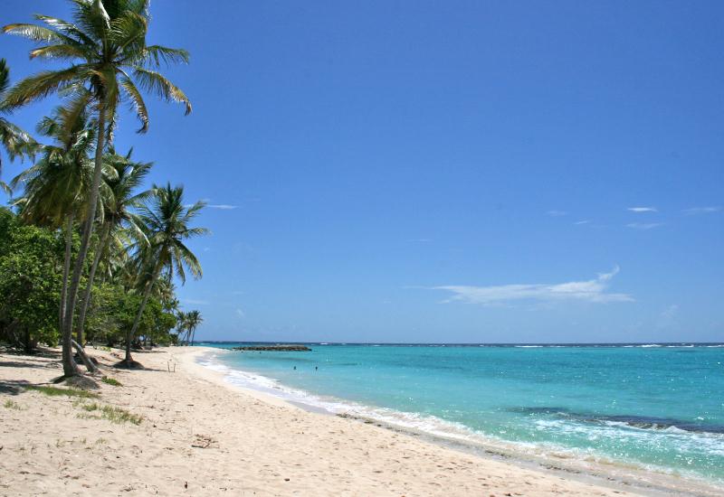
Capesterre-de-Marie-Galante: Living History, Deserted Beaches
Like elsewhere in the Antilles, prior to the Common Era this region was inhabited by Pre-Columbian peoples from South America, who lived off the area’s mangrove, seashore, and forest resources. Capesterre shares a common history with its neighboring communes, Grand-Bourg and Saint-Louis.
Arawaks lived in the area around Les Galets in about 300 C.E., as evidenced by petroglyphs, some of which were discovered in the caves of Morne Rita (“Rita Hill”) in the northeastern part of the island. Classified as a historical monument, this site features several faces at the entrance to the cave, in a rare instance in the Guadeloupe archipelago of carving in limestone, a fragile substance. Unfortunately, human contact was causing the petroglyphs to deteriorate, so the site was closed to the public. In addition to manioc, cotton was grown by the Amerindians for use in making ropes, clothing, and hammocks. They named the island “Aulinagan” (“Land of Cotton”), and cotton continued to be grown here until just over a century ago. The Amerindians also made ceramic objects, pottery and tools. For fishing, they used Amerindian rafts called “pri-pri,” made from the wood of the trumpet tree (Cecropia peltata). Most of the vestiges of this era that have been discovered are on display at the Edgar Clerc Museum in Le Moule.
On November 3, 1493, during his second voyage to the Antilles, Christopher Columbus landed on the southwestern part of this island, which he named “Maria Galanda” for his flagship. In November of 1648, Governor Houël sent about fifty colonists to the island in an attempt to seize it from the British. This initial colony was devoted mainly to growing food and tobacco crops. After a period of peaceful cohabitation, the colonists began encountering resistance from Carib people living on the island of Dominica, who had been using Marie-Galante as a supply base. The Caribs were repulsed, and forced to retreat to bluffs on the northern part of the island, which were protected by a barrier of keys. They remained there until the signing of a peace treaty in 1660, when they were allowed to leave for the islands of Dominica and Saint Vincent.
With the introduction of sugar cane in around 1655, new colonists from India settled here to create the first sugar factories, which, at that time, resembled hangars equipped with small animal-powered mills for crushing the cane.
Although cotton and indigo plantations were widespread (vestiges of indigo plantations may still be seen near Les Galets), the history of Capesterre, like that of its neighbors, is dominated by sugar cane.
The colonists attempted to add sugar cane to their traditional crops using slave labor. Slaves already represented half the population of the island. However, their efforts were thwarted by incessant fighting between the French and the Dutch, then the British, who occupied the island several times between 1676, year of the first pillage by the Dutch fleet, and 1816.
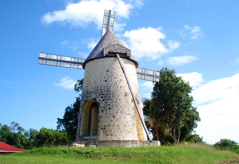
The French were eventually successful in launching the sugar economy, which grew over the course of the 18th century to the detriment of other agricultural sectors: tobacco, cotton, coffee, and indigo. The parish of “cab-est-terre“ (a French naval expression meaning “land exposed to east winds”) was established in around 1703. At that time, the sugar industry was streamlining processes, pooling lands, and introducing the first windmill (in 1738). However, this upward trajectory was interrupted by slave revolts, British attacks, and natural disasters, bringing about the ruin of some of the smaller operators. Added to all this was growing competition from Saint-Domingue and Jamaica. Finally, the French Revolution, the initial abolition of slavery in 1794, and yet another British occupation, led to the mass emigration of the planters.
The 19th century was a time of accelerated decline for secondary crops. Sugar cane growers were able to take advantage of the protectionist policies of the Restoration government to revive their operations. The sugar economy reached its peak between 1818 and 1835, with the development of many windmills (the island had 105 at that time). The vestiges of many windmills are still present in Capesterre, among them Bézard Mill, which has been fully restored and is now owned by the commune.
However, the earthquake of 1843, growing competition from sugar beets, and the definitive abolition of slavery in 1848 brought to an end the first historical cycle of Marie-Galante’s sugar industry. The last autonomous sugar plantations finally collapsed during the worldwide sugar recession of the late 19th century. In 1914, World War I ushered in a short period of prosperity for the island’s rum and sugar operators, with 18 distilleries in 1931, as well as four sugar refineries. The Bernard central sugar processing plant in the commune of Capesterre remained in operation from 1881 to 1923. In 1959, the closing of the Robert factory and six distilleries triggered violent social unrest.
Capesterre, which is now part of a community of communes that includes Grand-Bourg and Saint-Louis, continues to rely on sugar cane as the basis of its economy, but has also begun developing tourism by promoting its sugar cane heritage, preserving its many natural sites, and building several fine hotels and guesthouses offering visitors a warm welcome.
Tour of Capesterre-de-Marie-Galante
The commune of Capesterre (approximately 47 km2) is located on the eastern Atlantic shore of Marie-Galante Island. It consists mostly of a hilly plateau dropping into a coastal plain with some significant changes in elevation. To the north, the land is characterized by steep cliffs and the island’s highest point, Morne Constant (204 meters); to the south, long yellow-sand beaches hug a scalloped coastline protected by a barrier of keys, with a lagoon of emerald waters; inland, the landscapes feature waving cane fields, hidden paths, and untouched wilderness, along with historic Amerindian sites. Such are the treasures that await visitors to Capesterre-de-Marie-Galante.
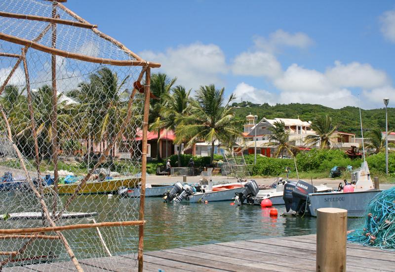
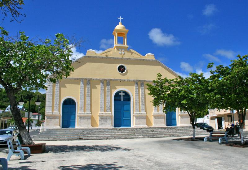
The charming town of Capesterre is a pleasant, peaceful village protected by a coral barrier reef. The port, tucked into the heart of town, is frequented by fishermen who gather there to sell their day’s catch: parrotfish, sturgeon, sea bream, tuna, and frigate tuna. Visit Governor Félix Eboué Square to see Sainte-Anne church, designed by Ali Tur—architect dispatched to Guadeloupe by the French government following the devastating hurricane of 1928—and the remarkable Town Hall with its bust of the Governor guarding the entrance. Nearby, on Rue Gabriel Bade, stands the primary school, whose central structure, aligned with the square, was built in 1931 in pure Ali Tur style (be sure to note the tiling and cornices). Traveling north on the coast road toward Capharnaüm, enjoy exceptional views from atop cliffs formed by the gradual emergence of the island’s bedrock limestone, with caves marking the former level of the sea (for example, at Les Galeries and Morne Rita). Admire the intense blue of the ocean, glimpsed between columnar cacti and coastal frangipani. Hike “Sentier des Galeries” (“Gallery Trail”), which follows the shoreline above crashing surf. The road continues past “La Grotte de Morne Rita” (“Rita Hill Cave”), which is classified as a historic monument (not open to the public), toward two isolated beaches in the coves of Anse Taliseronde and Anse Feuillard, frequented by lovers of scuba diving—and tranquility. The “Côte Est” (“East Coast”) footpath runs along the shoreline of Les Galets (“Pebbles”) on the approach to the cove of Anse Piton, traversed by the “Barre de l'Ile” (the island’s fault scarp). This major offset in the earth’s surface rises to a height of 120 meters, marking an abrupt transition between the island’s “Bas au Nord” (northern lowlands) and cliff-lined shore. From Morne La Vierge (“Virgin Hill”), enjoy a magnificent view overlooking the town. Traveling north, highway D 201 crosses sugar-cane fields studded with mills (Bontemps-Rameau Mill, with the ruins of the former refinery, and Nesmond Mill) to arrive at the hamlet of Grand Case. The road to the right leads to Petite Place wind farm, commissioned in 1998. Take highway D 201 to the well-preserved Desruisseaux Mill. One kilometer further, a path may be accessed leading to Anse Piton cove. Highway D 202 descends to the bottom of the central valley, leading to the mill at Etang Noir (“Black Pond”). Bézard Mill is less than two kilometers away, a moving legacy of the island’s prestigious sugar cane past. Bézard Mill is the first mill in the French Antilles to have been restored to its original state. The departmental highway continues to the Bellevue Distillery, with its restored mill (tours and tastings available). Traveling toward Capesterre, highway D 202 joins Highway N9. Along the way, vendors offer traditional cane syrup, a local product obtained after boiling the cane juice, and local cane-syrup-based pastries (various cookies, “caca bœuf”—“beef cake”—syrup-based candies, etc.).
To the east on Robert Plateau, overlooking Grande Ravine between the communes of Grand-Bourg and Capesterre, eroded limestone forms basins and sinkholes, with many ponds surrounded by unique vegetation and wildlife, including the Molokoy freshwater turtle. The plateau’s shady slopes were once used for growing cacao, coffee, and vanilla crops. In the direction of Pichery (a hiking trail across the heights of Capesterre comes through here), arrive directly at Petite Anse beach and the D 203 coastal road, which leads to the center of town past magnificent La Ferrière and La Feuillère beaches, offering exceptional views of the turquoise ocean. The overgrown ruins of the former Bernard sugar plant are just a few hundred meters off the road. Chemin Bleu tourist maps of Guadeloupe and city street maps are available at the Office of Tourism of Grand-Bourg.

-
Sightseeing

- South Basse-Terre: Thrilling Sensations in a Tropical Forest Setting
- Côte-sous-le-vent: Artisanal Craftsmanship and Spectacular Diving
- North Basse-Terre: Glimmers of Sugar Cane and Marine Breezes
- North Grande-Terre: Stunning Landscapes and Cane Traditions
- East Grande-Terre: Thrilling Emotions on Land and Sea
- West Grande-Terre: Colors, Flavors, and a Glorious Past
- Les Saintes: Marine Breezes and Sweet Relaxation
- Marie-Galante: Non-Stop Charm in the Land of Sugar
- La Désirade: Untouched Landscapes, Shared Emotions
-
Tourist
-
Communes

- Les Abymes
- Anse-Bertrand
- Baie-Mahault
- Baillif
- Basse-Terre
- Bouillante
- Capesterre-Belle-Eau
- Capesterre-de-Marie-Galante
- Deshaies
- La Désirade
- Le Gosier
- Gourbeyre
- Goyave
- Grand-Bourg
- Lamentin
- Morne-à-l'Eau
- Le Moule
- Petit-Bourg
- Petit-Canal
- Pointe-à-Pitre
- Pointe-Noire
- Port-Louis
- Saint-Claude
- Sainte-Anne
- Sainte-Rose
- Saint-François
- Saint-Louis
- Terre-de-Bas
- Terre-de-Haut
- Trois-Rivières
- Vieux-Fort
- Vieux-Habitants
Downloadable
-
See all places

- “La Renaissance” movie theater - Pointe-à-Pitre
- 1st and 2nd Carbet Waterfalls - Capesterre Belle-Eau
- 3rd Carbet Waterfall - Capesterre Belle-Eau
- 5 February 1967, Square - Petit-Canal
- 9 August 1882 Square - Terre-de-Bas
- Acomat Falls - Pointe-Noire
- Acomat Point - Trois-Rivières
- Adventitious Church of Vieux-Habitants - Vieux-Habitants
- Airfield - Saint-François
- AIslands Cove - Sainte-Rose
- Alexina Garden - Le Gosier
- Allée de la Liberté - Bouillante
- Allée Dumanoir - Capesterre Belle Eau
- Allée Dumanoir Recreational Area - Capesterre Belle-Eau
- Almond Tree Beach - Sainte-Rose
- Amédée Detreaux Velodrome - Baie-Mahault
- Amédée Fengarol Primary School - Capesterre Belle-Eau
- Amerindian Garden of the Edgar Clerc Museum - Le Moule
- Amerindian Heritage - Baillif
- Ancien monastère Saint-Antoine - Basse-Terre
- Anse à Sable Beach - Bouillante
- Anse Colas - Anse-Bertrand
- Anse Crawen - Terre-de-Haut
- Anse de Pigeon - Bouillante
- Anse du Fond Curé - Terre-de-Haut
- Anse du Souffleur beach - Port-Louis
- Anse Duché Beach - Bouillante
- Anse Dupuy - Vieux-Fort
- Anse Feuillard Cove - Capesterre de Marie-Galante
- Anse Laborde Beach - Anse-Bertrand
- Anse-Bertrand - 5 276 Hab.
- Aquaculture Park - Pointe-Noire
- Aquarium - Le Gosier
- Arboretum - Trois-Rivières
- Assainissement district - Pointe-à-Pitre
- Audoin River - Le Moule
- Babin Beach - Morne-A-l'Eau
- Back Cove - Terre-de-Bas
- Bagasse-Coal Plant - Le Moule
- Baie de Blachon - Lamentin
- Baie-Mahault - 31 069 Hab.
- Baillif - 5 801 Hab.
- Balloon Bridge - Sainte-Anne
- Banana Wood Waterfall - Lamentin
- Basse-Terre - 11 049 Hab.
- Battery Point - Deshaies
- Beach of the Other Side - Le Moule
- Beaufond Windmill - Anse-Bertrand
- Beauplaisir Windmill - Port-Louis
- Beauport Guadeloupe - Port-Louis
- Beautiran Path - Petit-Canal
- Beautiran Site - Petit-Canal
- Bébian school - Pointe-à-Pitre
- Begging Mayor Square - La Désirade
- Belin windmill - Port-Louis
- Belmont Plantation Slave Dungeon - Trois-Rivières
- Bernard Refinery - Capesterre de Marie-Galante
- Bétin plantation - Port-Louis
- Bettino Lara Media Library - Basse-Terre
- Beuthier windmill - Port-Louis
- Bézard windmill - Capesterre de Marie-Galante
- Bielle Distillery - Grand-Bourg
- Big Basin - Saint-Louis
- Big Hill - Deshaies
- Big Hole Pond - Terre-de-Bas
- Big Mouth Chasm - Saint-Louis
- Big Pond - Capesterre Belle Eau - Capesterre Belle-Eau
- Big Sand Beach - Sainte-Anne
- Bik-Kontakaz - Sainte-Anne
- Bisardy Plantation - Gourbeyre
- Bishopric - Basse-Terre
- Blackberry Bush Cove - Terre-de-Bas
- Blessed Savior Cove - Capesterre Belle-Eau
- Blondeau Plantation - Vieux-Fort
- Blonzac Aquatic Garden - Goyave
- Blower Beach - La Désirade
- Blue Pool - Gourbeyre
- Boat Cove - Saint-François
- Boat Cove - Bouillante
- Boat Cove - Vieux-Habitants
- Bois-Debout Plantation - Capesterre Belle-Eau
- Bologne Distillery - Basse-Terre
- Botanical Garden - Basse-Terre
- Botanical Garden - Deshaies
- Bouillante - 7 528 Hab.
- Bras du Fort Falls - Goyave
- Budan Windmill - Anse-Bertrand
- Bust of Augustin Gourbeyre - Gourbeyre
- Bust of Delgrès - Saint-François
- Bust of Delgrès - Deshaies
- Bust of Delgrès - Goyave
- Bust of Delgrès - Vieux-Habitants
- Bust of Félix Eboué - Pointe-à-Pitre
- Bust of Félix Eboué - Sainte-Rose
- Bust of General Frébault - Pointe-à-Pitre
- Bust of Jean Louis - Goyave
- Bust of Louis Delgrès - Pointe-Noire
- Bust of Lucien Bernier - Saint-François
- Bust of Victor Schœlcher - Morne-A-l'Eau
- Buste de Félix Eboué - Morne-A-l'Eau
- Cadoue Windmill - Anse-Bertrand
- Calvary Nature Park - Le Gosier
- Camille Soprann Square - Saint-Louis
- Camp Jacob - Saint-Claude
- Capès-Dolé Bottling Plant - Gourbeyre
- Capesterre Belle-Eau - 19 315 Hab.
- Capesterre de Marie-Galante - 3 355 Hab.
- Caraïbes Mountains - Vieux-Fort
- Caravelle Beach - Sainte-Anne
- Caravelle Surf Spot - Sainte-Anne
- Caribbean Beach - Pointe-Noire
- Caribbean Mountains - Gourbeyre
- Carmelite Square - Basse-Terre
- Carved Rock Archeological Park - Trois-Rivières
- Casino de Saint-François - Saint-François
- Cassava Factory - Sainte-Anne
- Cassava Factory - Petit-Bourg
- Cayenne Cemetery - Saint-François
- Cemetery - Morne-A-l'Eau
- Cemetery - Pointe-à-Pitre
- Cemetery Square - Le Moule
- Center for Embroidery and Textile Arts - Vieux-Fort
- Central Covered Market - Basse-Terre
- Central Market - Pointe-à-Pitre
- Champ d’Arbaud Parade Grounds - Basse-Terre
- Changy Hindu Temple - Capesterre Belle-Eau
- Chapel Beach - Anse-Bertrand
- Chapel Our Lady of Charity - Le Moule
- Chapelle Notre Dame de Guadeloupe - Saint-Claude
- Chapelle Notre Dame du Phare - La Désirade
- Chapelles - Port-Louis
- Chapp House - Basse-Terre
- Chevalier de Saint-Georges Square - Basse-Terre
- Christ the King Church at Les Mangles - Petit-Canal
- Church of Notre Dame du Bon Port - Petit-Bourg
- Church of Our Lady of Good Help - Port-Louis
- Church of Saint Phillip and Saint John - Petit-Canal
- Church of Saint-Louis - Bouillante
- Church of Sainte-Anne - Goyave
- Church of Sainte-Thérèse de l'Enfant Jésus - Petit-Bourg
- Church of St. John the Baptist - Le Moule
- Church of St. John the Baptist - Baie-Mahault
- Church of St. Peter and St. Paul - Deshaies
- Church of the Immaculate Conception - Les Abymes
- Church of the Immaculate Conception - Grand-Bourg
- Church Square - Saint-François
- Church Square - Saint-Louis
- Cicéron Alley - Basse-Terre
- Cimetière des Indiens - Saint-François
- Ciné-Théâtre - Lamentin
- City Hall - Les Abymes
- City Hall - Basse-Terre
- City Hall - Vieux-Habitants
- City Pavilion - Pointe-à-Pitre
- Claire Fontaine Plantation - Baillif
- Cliff Trace - Anse-Bertrand
- Cliffs - Vieux-Fort
- Cluny Beach - Sainte-Rose
- Cœur de Bouillante - Bouillante
- Coffee Museum - Vieux-Habitants
- Colo Pool - Petit-Bourg
- Colonial House - Le Moule
- Column and Bust of Marianne - Bouillante
- Commemorative plaque in homage to Justin Catayée - Pointe-à-Pitre
- Courthouse - Basse-Terre
- Crab House - Le Moule
- Crawfish Cascade - Petit-Bourg
- Crazy Cove Beach - Grand-Bourg
- Damencourt Nature Park - Le Moule
- Damoiseau Distillery - Le Moule
- Dampierre windmill - Le Gosier
- Datcha Beach - Le Gosier
- Delgrès Stele - Morne-A-l'Eau
- Departmental Residence - Le Gosier
- Descamps House, Birmingham Plantation - Baie-Mahault
- Deshaies - 4 215 Hab.
- Deshaies Cove - Deshaies
- Deshaies Diving - Deshaies
- Desmarais Distillery - Saint-Claude
- Dévarieux windmill - Petit-Canal
- Deville-Maisoncelle Path - Petit-Canal
- Diavet and Bwé ponds - Le Gosier
- Distillerie Bellevue - Capesterre de Marie-Galante
- Diving - Bouillante
- Dolé Public Pool - Gourbeyre
- Domaine de la Lise - Bouillante
- Domaine de St-Paul - Sainte-Anne
- Du Mont Cove - Le Gosier
- Duval Site - Petit-Canal
- Eco-museum of Guadeloupe - Sainte-Rose
- Eco-Touristic Park of Trois-Pointes - Vieux-Fort
- Edgar Clerc Museum - Le Moule
- Eiffel Bridge - Pointe-Noire
- Eiffel-style Bridges - Goyave - Goyave
- Eloi Germain Interpretive Garden - Terre-de-Bas
- Escape Hill - Sainte-Anne
- Escaped Slave Memorial - Sainte-Anne
- Espace Thermo-Ludique René Toribio - Lamentin
- Espace Wizosky - Le Moule
- Fanfan Beach - La Désirade
- Father Labat Tower - Baillif
- Fatima Chapel - Le Moule
- Félix Eboué Square - Capesterre de Marie-Galante
- Ferry Battery - Deshaies
- Ferry Cove - Deshaies
- Feuillère Beach - Capesterre de Marie-Galante
- Fidelin Pond - Les Abymes
- Fiesque Duchesne Stadium - Baie-Mahault
- Fifi Beach - La Désirade
- Fig Tree Beach - Terre-de-Haut
- Fishing and Pleasure Boat Port - Sainte-Rose
- Fishing and Pleasure Boat Port - Sainte-Rose
- Fishing Port - Saint-François
- Fishing Port - Le Moule
- Fishing Port - Deshaies
- Folle-Anse Cargo Port - Grand-Bourg
- Fontaine Adolphine - Saint-Claude
- Footbridge of the Two Banks - Le Moule
- Former Cotton Mill - La Désirade
- Former Dorot Distillery - Saint-Louis
- Former Duval Refinery - Petit-Canal
- Former Fidelin Pottery Works - Terre-de-Bas
- Former Grosse Montagne Sugar Plant - Lamentin
- Former health care center and maternity hospital - Port-Louis
- Former Law Courts - Port-Louis
- Former Leper Colony - La Désirade
- Former Marquisat Factory - Capesterre Belle-Eau
- Former Power Plant: La Friche - Baie-Mahault
- Former Prison - Petit-Canal
- Former Prison - Goyave
- Former Prison - Anse-Bertrand
- Former Rex movie theater - Port-Louis - Port Louis
- Former Saint-Jacques plantation - Saint-François
- Former Weather Station - La Désirade
- Fort Fleur d'Epée - Le Gosier
- Fort l'Olive - Vieux-Fort
- Fort Louis - Le Gosier
- Fort Louis Delgrès - Basse-Terre
- Fort Napoleon - Terre-de-Haut
- Fortune Islet - Goyave
- Fountain - Gourbeyre
- Fresque murale du lycée de Baimbridge - Les Abymes
- Gadet Lookout - Deshaies
- Galion Falls - Saint-Claude
- Galion Gorges - Saint-Claude
- Gardel Factory - Le Moule
- Gaschet Ravine - Petit-Canal
- Gates of Hell - Le Moule
- Gates of Hell - Anse-Bertrand
- Gédéon-Bambou park - Morne-A-L'Eau
- General Council Building - Basse-Terre
- Gertrude Square - Petit-Bourg
- Gerty Archimède Museum - Basse-Terre
- Gerville-Réache Secondary School - Basse-Terre
- Getz Plantation - Vieux-Habitants
- Gilles Floro Culture House - Gourbeyre
- Girard windmill - Petit-Canal
- Giratoire “Les amarreuses de Jabrun” - Baie-Mahault
- Gissac windmill - Sainte-Anne
- Godet windmill - Petit-Canal
- Good Mother Factory - Sainte-Rose
- Gourbeyre - 7 986 Hab.
- Gourd Cove Beach - Saint-François
- Goyave - 7 761 Hab.
- Grand Cove Beach - Deshaies
- Grand Cul-de-Sac Marin Bay - Sainte-Rose
- Grand Cul-de-Sac Marin Natural Preserve - Baie-Mahault
- Grand Pierre windmill - Saint-Louis
- Grand-Anse Beach - Terre-de-Bas
- Grand-Bourg - 5 409 Hab.
- Grand-Bourg Beach - Grand-Bourg
- Grand-Point Battery - Trois-Rivières
- Grande Anse Sugar Refinery - Grand-Bourg
- Grande Rivière à Goyaves - Lamentin
- Grande Vigie Point - Anse-Bertrand
- Grande-Anse Battery - Trois-Rivières
- Grandfond Windmill - Anse-Bertrand
- Grands Fonds - Le Gosier
- Grands Fonds - Sainte-Anne
- Grands Fonds - Le Moule
- Grands Fonds - Les Abymes
- Great Cove Beach - Trois-Rivières
- Greenery Point - Le Gosier
- Guyonneau Plantation - Deshaies
- Habitation Desmarets - Basse-Terre
- Habitation La Mahaudière - Anse-Bertrand
- Harbor Terminal - Saint-François
- Helleux Surf Spot - Sainte-Anne
- Henry Sidambarom Stela - Capesterre Belle-Eau
- Heritage House - Basse-Terre
- Hiking Trails - Gourbeyre
- Hiking Trails - La Désirade
- Hiking Trails - Terre-de-Bas
- Hiking Trails - Pointe-Noire
- Hindu temple - Les Abymes
- Hindu Temple of Gaschet - Port-Louis
- Hot baths of Matouba - Saint-Claude
- House of Bananas - Trois-Rivières
- House of Cacao - Pointe-Noire
- House of the Elders - Basse-Terre
- Hummingbird Point - La Désirade
- Ilet Boissard - Pointe-à-Pitre
- Ilet Caret - Sainte-Rose
- Ilets de Carénage, Ilet Blanc, Ilet la Biche - Sainte-Rose
- Indian Memorial - Saint-François
- Information Office and Bust of Louis Delgrès - Gourbeyre
- International Golf Course - Saint-François
- Isle of the Goats - Terre-de-Haut
- Jardin de la Rencontre - Capesterre Belle-Eau
- Jérôme Cléry Municipal Auditorium - Basse-Terre
- Jolan Woods Beach - Sainte-Anne
- Karukera Rum Distillery - Capesterre Belle-Eau
- Karuptures – Totem, Work of Edgar Negret - Lamentin
- Karuptures, Lumi-Naissance - Lamentin
- Karuptures, Madonna and Child, work of Leopoldo Maler - Lamentin
- Karuptures, Physiochromie du Lamentin, work of Carlos Cruz Diez. - Lamentin
- Karuptures, Tribute to the abolition of human slavery, work of Erik Dietman - Lamentin
- Kreol West Indies - Grand-Bourg
- Kreol West Indies Museum Space - Saint-François
- L’Herminier House - Pointe-à-Pitre
- L’il Cove Beach - Pointe-Noire
- La Coulisse - Trois-Rivières
- La Darse - Pointe-à-Pitre
- La Désirade - 1 549 Hab.
- La Grivelière Plantation - Vieux-Habitants
- La Lézarde Falls - Petit-Bourg
- La Lézarde River - Petit-Bourg
- La Mahaudière Windmill - Anse-Bertrand
- La Marianne - Pointe-Noire
- La Pastorale House - Trois-Rivières
- La Ramée Plantation - Sainte-Rose
- La Rose Plantation - Goyave
- Ladder Cove - La Désirade
- Lagoon Beach - Saint-François
- Lake Gaschet - Port-Louis
- Lamentin - 16 313 Hab.
- Latchmansing temple - Shiva temple - Saint-François
- Laura Flessel Sports Complex - Petit-Bourg
- Le Chameau - Terre-de-Haut
- Le Gosier - 27 920 Hab.
- Le Gosier Islet - Le Gosier
- Le Moule - 22 404 Hab.
- Leeward Coast House - Vieux-Habitants
- Leroux Beach - Deshaies
- Les Abymes - 56 581 Hab.
- Letaye Dam - Le Moule
- Lethière Street - Sainte-Anne
- Lethière Traffic Circle - Sainte-Anne
- Liberty Square - Basse-Terre
- Lighthouse - Vieux-Fort
- Little Cove Beach - Capesterre de Marie-Galante
- Little River Beach - La Désirade
- Loiseau Plantation - Vieux-Habitants
- Louis Delgrès Stela - Saint-Claude
- Lovers’ Pool - Gourbeyre
- Lubeth windmilll - Petit-Canal
- Lycée Carnot - Pointe-à-Pitre
- Maison de la Forêt - Petit-Bourg
- Maison de la Mangrove - Les Abymes
- Maison Monnerville - Morne-A-l'Eau
- Maisons typiques - Anse-Bertrand
- Malendure Beach - Bouillante
- Mambia beach - Sainte-Rose
- Mamelles Zoological Park - Bouillante
- Man Réaux Mall - Pointe-à-Pitre
- Mangrove Swamp - Le Gosier
- Mangrove Swamps - Petit-Canal
- Mangrove Swamps - Saint-Louis
- Mangrove-la Ka - Port-Louis
- Manioc Factory - Deshaies
- Marigot Bay - Terre-de-Haut
- Marina - Saint-François
- Marina - Le Gosier
- Marina - Pointe-à-Pitre
- Marina traffic circle - Pointe-à-Pitre
- Marius Chipotel Square - Sainte-Anne
- Market - Sainte-Anne
- Market - Capesterre Belle-Eau
- Marquisat de Sainte-Marie Estate - Capesterre Belle-eau
- Marshes - Port-Louis
- Massabielle church - Pointe-à-Pitre
- Massif de la Madeleine - Trois-Rivières
- Matouba Factory - Saint-Claude
- Matouba Falls - Saint-Claude
- Maurice Cove - Petit-Canal
- Max Mathurin Stela - La Désirade
- Mayoumbé windmill - Saint-Louis
- Mays Cove - Saint-Louis
- Médiathèque Ernest J. Pépin - Lamentin
- Mémorial ACTe - Pointe-à-Pitre
- Mémorial aux victimes de 1925 - Petit-Canal
- Memorial to the First Day - Pointe-à-Pitre
- Memorial to the Sacrifice of Delgrès - Les Abymes
- Memorial to the victims of May 1967 - Pointe-à-Pitre
- Memorial to Victor Schoelcher - Vieux-Habitants
- Mémorial Victor Schœlcher - La Désirade
- Memorial Wall - Les Abymes
- Ménard windmill - Saint-Louis
- Michaux windmill - Petit-Canal
- Mills - Saint-François
- Moko Bridge - Lamentin
- Moko Bridge - Sainte-Rose
- Montal Beach - Le Moule
- Montebello Distillery - Petit-Bourg
- Monument aux morts - Anse-Bertrand
- Monument aux morts (“War Memorial”) - Lamentin
- Monument of the Eternal Flame to the Unknown Slave - Petit-Canal
- Monument to Christopher Columbus - Capesterre Belle-Eau
- Monument to Freedom - Petit-Canal
- Moreau Falls - Goyave
- Moreau Interpretive Trail - Goyave
- Morel Trace - Terre-de-Haut
- Morne Calvaire - Les Abymes
- Morne de la Mémoire - Les Abymes
- Morne-à-l'Eau - 17 504 Hab.
- Morne-Rouge School - Sainte-Rose
- Murat Plantation and Eco-Museum of Marie-Galante - Grand-Bourg
- Musée de la graine - Trois-Rivières
- Museum of Costumes and Traditions - Le Gosier
- Museum of Days Gone By - Petit-Canal
- National Theater - Basse-Terre
- Nature Park - Petit Canal
- Neg Mawon Stela - Petit-Bourg
- Néron Plantation - Le Moule
- Night Market - Saint-François
- Night Market - Sainte-Anne
- Night Market - Petit-Bourg
- Notre Dame du Mont-Carmel Church - Basse-Terre
- Notre Dame Sanctuary - Deshaies
- Notre-Dame de Guadeloupe Cathedral - Basse-Terre
- Novilos Courtyard - Basse-Terre
- Nozières Bridge - Saint-Claude
- Oceanfront - Basse-Terre
- Old Mill Trace - Petit-Canal
- Old Town Hall - Saint-Claude
- Olive Bay - Saint-François
- Olympe Victor Auguste Combes Giratoire - Lamentin
- Open-Air Theater - Lamentin
- Oratory - Goyave
- Ornithological site of Ravine Sable - Anse-Bertrand
- Osange Talis Gane Multimedia Library - Sainte-Anne
- Ouatibi Tibi Park - Le Moule
- Our Lady of Calvary Chapel - La Désirade
- Our Lady of Good Help Church - La Désirade
- Our Lady of Good Hope - Morne-A-l'Eau
- Our Lady of Jarry Chapel - Baie-Mahault
- Our Lady of the Assumption Church - Terre-de-Haut
- Our Lady of the Assumption Church - Pointe-Noire
- Our Lady of the Assumption Church - Trois-Rivières
- Palace of Culture Felix Proto - Les Abymes
- Palais d'Orléans (Prefecture Building) - Basse-Terre
- Paradise Pool - Capesterre Belle-Eau
- Paradoxe Croisières - Saint-François
- Parc de la Source - Bouillante
- Parc de la Verdure - Lamentin
- Parc National - Saint-Claude
- Paul Aubin windmill - Port-Louis
- Paul Lacavé Memorial - Capesterre Belle-Eau
- Paul Mado Multimedia Library - Baie-Mahault
- Paved Path Ravine - Le Gosier
- Pearl Beach - Deshaies
- Pebble Beach - La Désirade
- Pebble Cove - La Désirade
- Perrin Canal - Les Abymes
- Petit Carbet Plantation-Refinery - Trois-Rivières
- Petit Cul-de-Sac Marin - Petit-Bourg
- Petit-Bourg - 24 507 Hab.
- Petit-Canal - 8 262 Hab.
- Petit-Havre Beach - Le Gosier
- Petite Anse Cove - Terre-de-Bas
- Petite Terre - La Désirade
- Petite-Anse beach - Bouillante
- Pichon Square - Basse-Terre
- Pigeon Isles - Bouillante
- Place Camille Desmoulins - Pointe-à-Pitre
- Place de la Mairie - Bouillante
- Place de la Victoire - Pointe-à-Pitre
- Place Frédéric Jalton - Les Abymes
- Place Gerty Archimède - Morne-A-l'Eau
- Place Gourbeyre - Pointe-à-Pitre
- Plage de Grande-Anse - Terre-de-Haut
- Plage de l'Anse Canot - Saint-Louis
- Plage de la Porte d'Enfer - Anse-Bertrand
- Plage de Moustique - Saint-Louis
- Plaine de Grippon - Morne-A-l'Eau
- Plaisance windmill - Port-Louis
- Plantation Grand Café - Capesterre Belle-Eau
- Plate Point Trail - Anse-Bertrand
- Plateau du Palmiste - Gourbeyre
- Platform of Beron (Bonne Mère) - Sainte-Rose
- Point Bleu Soleil - Gourbeyre
- Point Helleux Beach - Sainte-Anne
- Pointe Allègre - Sainte-Rose
- Pointe des Châteaux - Saint-François
- Pointe-à-Pitre - 16 427 Hab.
- Pointe-Noire - 6 519 Hab.
- Poisson Distillery - Grand-Bourg
- Pôle Caraïbes Airport - Les Abymes
- Polishing block of Dindé - Sainte-Rose
- Pompierre Beach - Terre-de-Haut
- Pond Beach - Vieux-Habitants
- Pond Trace Hiking Trail - Capesterre Belle-Eau
- Ponds - Anse-Bertrand
- Pont de la rivière du Plessis - Baillif
- Port - Petit-Canal
- Port - Port-Louis
- Port - La Désirade
- Port - Capesterre de Marie-Galante
- Port - Grand-Bourg
- Port - Saint-Louis
- Port - Baie-Mahault
- Port de Vieux-Bourg - Morne-A-l'Eau
- Port Galbas - Sainte-Anne
- Port of Jarry - Baie-Mahault
- Port-Louis - 5 867 Hab.
- Pottery Kiln - Trois-Rivières
- Poyen windmill - Petit-Canal
- Presbytery - Port-Louis
- Primary School “Alice Delacroix“ - Petit Canal
- Public Park and Fountain - Trois-Rivières
- Pulling bull contests - Anse-Bertrand
- Pulling bull contests - district of Guéry - Anse-Bertrand
- Pulling Bulls - Baie-Mahault
- Punch Pond and Pirogue Factory - Grand-Bourg
- Rambouillet Cross - Port-Louis
- Raoul Georges Nicolo Media Library - Le Gosier
- Ravine Sable (Sand Ravine) - Anse-Bertrand
- Red Bridge - Deshaies
- Red Head - Terre-de-Haut
- Regional Council of Guadeloupe - Basse-Terre
- Rémy Nainsouta Center - Pointe-à-Pitre
- René Boisneuf Multimedia Library - Pointe-à-Pitre
- Réserve Cousteau - Bouillante
- Rifflet Beach - Deshaies
- Ring of Slavery - Pointe-à-Pitre
- Rivière de la Coulisse - Trois-Rivières
- Rocroy Beach - Vieux-Habitants
- Rodriguez Cove - Terre-de-Haut
- Rooster Cove - Saint-Louis
- Roseau Beach - Capesterre Belle-Eau
- Rotours Canal - Morne-A-l'Eau
- Roussel-Trianon Sugar Planation - Grand-Bourg
- Rue Achille-René Boisneuf - Pointe-à-Pitre
- Rue Frébault - Pointe-à-Pitre
- Rum Museum - Sainte-Rose
- Sailing Center - Goyave
- Saint Anne Church - Capesterre de Marie-Galante
- Saint Bernadette Church of Grands Fonds - Sainte-Anne
- Saint Denis Church - Anse-Bertrand
- Saint Dominic Church - Baillif
- Saint Hyacinth Church - Capesterre Belle-Eau
- Saint Rose of Lima Church - Sainte-Rose
- Saint-Albert Church - Vieux-Fort
- Saint-André church - Morne-A-l'Eau
- Saint-Augustin Church - Saint-Claude
- Saint-Charles Borromée Church - Gourbeyre
- Saint-Claude - 10 587 Hab.
- Saint-Felix Beach - Le Gosier
- Saint-François - 14 609 Hab.
- Saint-Jacques Racetrack - Anse-Bertrand
- Saint-John Perse Museum - Pointe-à-Pitre
- Saint-Joseph Church - Vieux-Habitants
- Saint-Joseph de Cluny Day School - Pointe-à-Pitre
- Saint-Louis - 2 540 Hab.
- Saint-Louis Beach - Saint-Louis
- Saint-Louis Church - Le Gosier
- Saint-Louis Plantation - Baillif
- Saint-Nicolas Church - Terre-de-Bas
- Saint-Pierre and Saint-Paul church - Pointe-à-Pitre
- Sainte-Anne - 25 037 Hab.
- Sainte-Anne Church - Sainte-Anne
- Sainte-Claire Beach - Goyave
- Sainte-Rose - Sainte-Rose
- Sainte-Trinité Church - Lamentin
- Saintes Bay - Terre-de-Haut
- Salabouelle Cove - Le Moule
- Saline Beach - Le Gosier
- Saltwork Beach - Le Gosier
- Salty Cove - Capesterre Belle-Eau
- Sans Fenêtre Windmill - Anse-Bertrand
- Sarrault Square - Petit-Bourg
- Schœlcher Museum - Pointe-à-Pitre
- Schœlcher Square - Sainte-Anne
- Sé la vi la ki pli bèl (“Life is Beautiful”) Sculpture - Basse-Terre
- Seashore - Pointe-Noire
- Seaside cemetery - Port-Louis
- Sens River Beach - Gourbeyre
- Sens River Marina - Gourbeyre
- Sentier de l'Acomat - Trois-Rivières
- Sentier Lavolvaine - Port-Louis
- Séo Pond - Sainte-Anne
- Séverin Estate - Sainte-Rose
- Shell House - Basse-Terre
- Shoreline Trail - Le Gosier
- Shrine of Our Lady of Tears - Pointe-Noire
- Silver Basin Port - Pointe-Noire
- Simaho Beach - Vieux-Habitants
- Simonière pond - Saint-François
- Site of the 1962 Boeing Jet Crash - Deshaies
- Slave Cemetery - Capesterre Belle-eau
- Slave Memorial - Saint-François
- Slave Steps - Petit-Canal
- Small Fort - Le Moule
- Social Hall - Lamentin
- Sofaïa Sulfur Springs - Sainte-Rose
- Sonis Cultural Center - Les Abymes
- Source de Poucet - Le Gosier
- Source de Thomas - Bouillante
- Source of the Rivière Rouge - Saint-Claude
- Sports Center - Le Gosier
- Spot de Damencourt - Le Moule
- Spot de La Bouelle - Le Moule
- Spot de La Chapelle - Anse-Bertrand
- Spot de La Station - Le Moule
- Square Christophe Colomb (Christopher Columbus Square) - Baie-Mahault
- Square Guy Cornély - Les Abymes
- Statue of Gandhi - Saint-François
- Statue of Joseph Ignace - Les Abymes
- Statue of Martin Luther King - Saint-François
- Statue of Nelson Mandela - Les Abymes
- Statue of the mulatto woman, “Solitude” - Les Abymes
- Statue of Vélo, the King of ka - Pointe-à-Pitre
- Sucrerie de Nogent - Sainte-Rose
- Sugar Cane Tradition - Baie-Mahault
- Sugar Loaf Mountain - Terre-de-Haut
- Sylvathèque - Gourbeyre
- Tabarin Cove Beach - Le Gosier
- Taliseronde Beach - Capesterre de Marie-Galante
- Tarare Cove - Saint-François
- Teddy Riner Square - Vieux-Habitants
- Terre-de-Bas - 1 097 Hab.
- Terre-de-Haut - 1 699 Hab.
- The Carénage district - Pointe-à-Pitre
- The district of “Grand-Baie“ - Le Gosier
- The Former Arsenal - Basse-Terre
- The former City Hall - Les Abymes
- The former Darboussier factory - Pointe-à-Pitre
- The former factory in Blanchet - Morne-à-l'Eau
- The former factory in Pointe-à-Retz - Morne à l'Eau
- The Galleries - Capesterre de Marie-Galante
- The Geothermal Plant - Bouillante
- The Law Courts - Pointe-à-Pitre
- The Mutual Insurance Building - Pointe-à-Pitre
- The New Courthouse - Pointe-à-Pitre
- The Observer - Deshaies
- The Old Municipal Jail - Bouillante
- The Old Town Hall - Bouillante
- The Pointe des Châteaux Cross - Saint-François
- The Port - Petit-Bourg
- The Port - Goyave
- The Rotunda - Saint-François
- The Sulfurer Volcano - Saint-Claude
- Three Bridges - Sainte-Anne
- Three Islands Beach - Grand-Bourg
- Three-Horn Falls - Sainte-Rose
- Tillet Beach - Deshaies
- Tourist House - Saint-Claude
- Town Beach - Sainte-Anne
- Town Hall - Sainte-Anne
- Town Hall - Morne-A-l'Eau
- Town Hall - Port-Louis
- Town Hall - Grand-Bourg
- Town Hall - Capesterre de Marie-Galante
- Town Hall - Petit-Bourg
- Town Hall - Sainte-Rose
- Town Hall - Lamentin
- Town Hall - Pointe-Noire
- Town Hall - Capesterre Belle-Eau
- Town Hall - Trois-Rivières
- Town Hall - Baillif
- Town Hall - Saint-Claude
- Town Hall - Baie-Mahault
- Town Hall - Petit-Canal
- Town Hall Square - Terre-de-Haut
- Town Hall Square - Petit-Bourg
- Tradewinds Beach - Le Moule
- Traditional Houses - Petit-Bourg
- Traditional Houses - Pointe-Noire
- Traditional Houses - Basse-Terre
- Trois-Rivières - 8 625 Hab.
- Typical houses - Port-Louis
- Typical houses - Pointe-à-Pitre
- Typical houses - Morne-à-l'Eau - Morne à l'Eau
- Valombreuse Gardens - Petit-Bourg
- Vanibel Estate - Vieux-Habitants
- Vernou Residential Quarter - Petit-Bourg
- Viard Beach - Petit-Bourg
- Viard River - Sainte-Rose
- Victor Schœlcher Column - Anse-Bertrand
- Victor Schœlcher Square - Grand-Bourg
- Victor Servan Soliman Nature Park - Petit-Bourg
- Vieux-Bourg church - Morne-A-l'Eau
- Vieux-Fort - 1 897 Hab.
- Vieux-Fort Beach - Saint-Louis
- Vieux-Habitants - 7 602 Hab.
- Volcanology and Seismology Laboratory - Gourbeyre
- Walking and Hiking - Bouillante
- War Memorial - Sainte-Anne
- War Memorial - Petit-Canal
- War Memorial - Port-Louis
- War memorial - Pointe-à-Pitre
- War Memorial - Les Abymes
- War Memorial - Saint-Louis
- War Memorial - Baie-Mahault
- War Memorial - Petit-Bourg
- War Memorial - Pointe-Noire
- War Memorial - Capesterre Belle-Eau
- War Memorial - Vieux-Habitants
- Water Cove - Saint-François
- Water Sports Center - Saint-François
- Water Sports Center - Sainte-Anne
- Water Sports Center - Sainte-Rose
- Waterfront - Sainte-Anne
- Waterfront - Baie-Mahault
- Waterfront Boulevard - Le Moule
- Wharf - Trois-Rivières
- White Grape Beach - Saint-François
- White Water Bridge - Le Moule
- Wind Farms - Capesterre de Marie-Galante
- Wind Turbines - La Désirade
- Wind Turbines - Terre-de-Bas
- Wonche Colonial House - Baie-Mahault
- World Trade Center Complex - Baie-Mahault
- Yellow Baths - Saint-Claude

-
See all businesses

- A2L Parapente Guadeloupe - Air - Le Moule
- Aérodrome de Saint-François - Air - Saint-François
- Aéroport Pôle Caraïbes - Air - Les Abymes
- Air Guadeloupe - Paragliding flight - Le Moule
- Alizé Plongée - Nautical - Bouillante
- Alizés Vacances - Apartment - Le Moule
- Anny Location - Car - Deshaies
- Anny Location - Car - Pointe-Noire
- Anse Auto Services - Car - Anse-Bertrand
- Archipel (Comadile) - Sea - Saint-Francois
- Archipel (Comadile) - Sea - La Désirade
- Atmosphère - Water Sports - Sainte-Anne
- Atmosphère - Water Sports - Sainte-Anne
- Atmosphère - Water Sports - Le Gosier
- Au Bon Vivre - Sea view - Terre-de-Haut
- Au Jardin des Colibris - Cottage - Deshaies
- Au Petit Grill - Sea view - Terre-de-Bas
- Auberge de la Vieille Tour - Hotel - Le Gosier
- Auberge Le Grand Large - Hotel - Sainte-Anne
- Auto Discount - Car - Saint-François
- Autolagon - car - Les Abymes
- Autolagon - Car - Petit-Canal
- Autolagon - Car - Anse-Bertrand
- Autolagon - Car - Port-Louis
- Aventure Cétacés - Excursions - Bouillante
- Beleau car - Car - Capesterre Belle-Eau
- Bellevue Gîtes - Cottage - Petit-Bourg
- Bik Kontakaz - Land - Sainte-Anne
- Burner Location - Car - Sainte-Rose
- Bwa Chic - Hotel - Saint-François
- Café de la Marine - sea view - Terre-de-Haut
- Canella Beach - Hotel - Le Gosier
- Caneval Elian - Car - Grand-Bourg
- Cap Sud Caraïbes - Hotel - Le Gosier
- Caprice des iles - Sea view - Baillif
- Capthéo2 - Two-wheeled - Terre-de-Haut
- Caraïb' Bay Hotel - Hotel - Deshaies
- Caraïbe Kayak - Kayak rental - Snorkeling - Bouillante
- Caraïbes Flyboard - Water sports - Port-Louis
- Caraïbes Gliss - Water sports - Pointe-Noire
- Carrefour Location - Car - Baie-Mahault
- Charly Excursions - Nautical excursion - Terre-de-Haut
- Chez Clara - Sea view - Sainte-Rose
- Chez Denis - Country - Gourbeyre
- Chez Gisèle & Philippe - Cottage - Terre-de-Haut
- Chez Joby Jack - Holiday cottage - Anse-Bertrand
- Choukasik - Local Product - Port-Louis
- Chris Auto - Car - Sainte-Anne
- Chris Auto - Car - Saint-François
- Claude'Car - Car - Bouillante
- Club Caravelle - Cottage - La Désirade
- Club Med - Hotel - Sainte-Anne
- Coco Beach Resort - Hotel - Grand-Bourg
- Cœur Caraïbes - Cottage - Deshaies
- Cubix Location - Car - Grand-Bourg
- Cubix Location - Saint-Louis
- Domaine de Belle Plaine - Landscape - Sainte-Rose
- Domaine de la Grande Vigie - Holiday cottage - Anse-Bertrand
- Domaine de Vanibel - Cottage - Vieux-Habitants
- Donuts BBQ Boat - Boat rental without a license - Saint-François
- Ecovolt Rent - Car - Sainte-Rose
- Ediloca - Rent a car - Vieux-Fort
- ELI Autogire - Air - Grand-Bourg
- Elite Location - Car - Bouillante
- Entre ciel et mer - Sea view - Le Gosier
- Espace Caraïbes - Holiday cottage - Anse-Bertrand
- Fanélie Location - Cottage - Deshaies
- Get Out Guadeloupe - Escape Game - Baie-Mahault
- Gina Auto - Rent a car - Pointe-à-Pitre
- Gîtes Ayonbety - Cottage - Le Moule
- Gîtes Kaladja - Cottage - Port-Louis
- Gîtes Laroseraie - Cottage - Lamentin
- Gîtes Les Colibris - Cottage - Saint-Claude
- Gîtes Pavillon - Cottage - Gourbeyre
- GPE Plongée - Sea - Bouillante
- Green Blue House - Apartment - Saint-François
- Guada Découverte - Sea - Sainte-Rose
- Guadeloupe Pêches Sportives - Water sports - Pointe-Noire
- Gwad Loc - Car - Petit-Bourg
- Gwada Drink Bike - Drink Bike - Saint-François
- Gwada Pagaie - Sea - Bouillante
- Gwadacar - Car - Sainte-Anne
- Gwadive - Water sports - Port-Louis
- Habitation du Comté - Country - Sainte-Rose
- Habitation Grande Anse - Apartments - Deshaies
- Habitation Thara - Cottage - Le Moule
- Hostellerie des Châteaux - Hotel - Saint-François
- Hôtel Clipper - Hotel - Le Gosier
- Hôtel Fleur d'Epée - Hotel - Le Gosier
- Hôtel Fort Royal - Hotel - Deshaies
- Hôtel La Maison Créole - Hotel - Le Gosier
- Hôtel Le Petit Havre - Hotel - Le Gosier
- Hôtel Résidence Le Golf Village - Hotel - Saint-François
- Hôtel Rotabas - Hotel - Sainte-Anne
- Hôtel Salako - Hotel - Le Gosier
- Hôtel St-John Perse - Hotel - Pointe-à-Pitre
- Iguana Beach (Comatrile) - Sea - Saint-François
- Iguana Beach (Comatrile) - Sea - Terre-de-Haut
- Iguana Beach (Comatrile) - Sea - Saint-Louis
- Iguana Locations - Car - Terre-de-Bas
- Iguane Café - Sea view - Saint-François
- Jardin Malanga Hôtel - Hotel - Trois-Rivières
- Jericho Gîtes et Spa - Apartment - Capesterre de Marie-Galante
- Jumbo Car - Rent à car - Les Abymes
- Jumbo Car - Rent a car - Le Gosier
- Jumbo Car - Rent a car - Baillif
- Jumbo Car - Rent a car - Gourbeyre
- Jumbo Car - Rent a car - Baie-Mahault
- Jumbo Car - Rent a car - Sainte-Anne
- Karukera Surf Club - Surf - Le Moule
- Kazanne - Cottage - Pointe-Noire
- L'Anthonis - City centre - Anse-Bertrand
- L'Océanite - Country - Saint-Louis
- La Belle Chaudière - Country - Lamentin
- La Case à Fernand - City centre - Anse-Bertrand
- La Case Créole - Town - Gourbeyre
- La Cocoteraie - Hotel - Saint-François
- La Colline Verte - Cottage - Deshaies
- La Créole Beach Hôtel & Spa - Hotel - Le Gosier
- La Dilettante - Cottage - Terre-de-Bas
- La Ferme Ti-Bou - Discovery farm - Petit-Bourg
- La Kaz à Coyoky - Cottage - Anse-Bertrand
- La Paillotte - Sea view - Terre-de-Haut
- La Payotte - Sea view - La Désirade
- La Playa - Sea view - Capesterre de Marie-Galante
- La Pointe d'Argent - Hotel - Pointe-Noire
- La Rhumerie du Pirate - Sea view - Saint-François
- La route du Rhum - Sea view - Pointe-à-Pitre
- La Toubana Hôtel & Spa - Hotel - Sainte-Anne
- La Toumbana - Country - Terre-de-Haut
- La Vallée de Guéry - Holiday cottage - Anse-Bertrand
- La Vieille Sucrerie - Cottage - Saint-Claude
- Le Banana's Plage - Sea view - Deshaies
- Le Bougainvilliers Blanc - Pointe-Noire
- Le Domaine du Rocher Noir - Cottage - Pointe-Noire
- Le Grillo - Country - Petit-Canal
- Le Jardin Tropical - Cottages - Bouillante
- Le Kontiki - Sea view - Sainte-Anne
- Le Loueur 971 - Car - Le Gosier
- Le M Hôtel de charme - Hotel - Capesterre de Marie-Galante
- Le Nautilus - Sea - Bouillante
- Le Parc aux Orchidées - Cottage - Pointe-Noire
- Le Phare - Sea view - Vieux-Fort
- Le Poisson d'Or - Sea view - Port-Louis
- Le Rayon Vert - Hotel - Deshaies
- Le Rocher de Malendure - Sea view - Bouillante
- Le Soleil Levant - Hotel - Capesterre de Marie-Galante
- Le Tam Tam - Town - Le Gosier
- Le Tapeur - Landscape - Pointe-Noire
- Le Touloulou - Sea view - Capesterre de Marie-Galante
- Le Verger de Sainte-Anne - Cottage - Sainte-Anne
- Le Vieux Port - Sea view - Saint-François
- Les Balançoires - Sea view - Terre-de-Haut
- Les Bananes Vertes - Cottage - Saint-Claude
- Les Cycas - Cottage - Saint-Claude
- Les Flots Bleus - Cottage - La Désirade
- Les Fruits de Goyave - Cottage - Goyave
- Les Gîtes de l'Union - Holiday cottage - Les Abymes
- Les Hauts de Deshaies - Cottage - Deshaies
- Les Heures Saines - Sea - Bouillante
- Les Orchidées de Sainte-Anne - Cottage - Sainte-Anne
- Les Petits Figuiers - Cottage - Terre-de-Haut
- Les Villas de Tisource - Cottage - Pointe-Noire
- Lisa Locations - Car - Capesterre Belle-Eau
- LoBleu - Hotel - Terre-de-Haut
- Locama - Car - Pointe-Noire
- Location Réflexe - Car - Baie-Mahault
- Loisirs aux Saintes - Sea - Terre-de-Haut
- Magaloc - Car - Les Abymes
- Magaloc - Car - Grand-bourg
- Magaloc - Car - Saint-Louis
- Magauto - Car - Grand-bourg
- Magauto - Car - Saint-Louis
- Majesty Palm - Apartment - Saint-François
- Majesty Palm - Sea - Saint-François
- Mawaly - Nautical excursion - Terre-de-Haut
- MG Auto - Car - Grand-Bourg
- MKG Centre Nautique - Water sports - Deshaies
- Moreau Ranch - Landscape - Goyave
- Noé Bus Tour - Land - Baie-Mahault
- O Cœur de Deshaies - Cottage - Deshaies
- Paradis Tropical - Holiday Cottage - Baillif
- Paradoxe Croisières - Sea - Saint-Francois
- Parc Aquacole - Land - Pointe-Noire
- Pharmacie Louis - Pharmacy - Le Gosier
- Pharmaciy Grand Baie - Pharmacyl - Le Gosier
- Pharmacy Allard François Nicole - Pharmacy - Pointe-à-Pitre
- Pharmacy Azar - Pharmacy - Le Moule
- Pharmacy Baie Side - Pharmacy - Petit-Bourg
- Pharmacy Bajoc Cornélie - Pharmacy - Morne-A-L'Eau
- Pharmacy Beaubois-Boucard - Pharmacy - Les Abymes
- Pharmacy Belcourt - Baie-Mahault
- Pharmacy Bernos - Pharmacy - Gourbeyre
- Pharmacy Berry - Pharmacy - Sainte-Rose
- Pharmacy Berthelot - Pharmacy - Pointe-à-Pitre
- Pharmacy Berthelot - Pharmacy - Pointe-à-Pitre
- Pharmacy Berthelot - Pharmacy - Le Moule
- Pharmacy Cap Santé - Pharmacy - Baie-Mahault
- Pharmacy Capet - Pharmacy - Les Abymes
- Pharmacy Carmentine - Pharmacy - Goyave
- Pharmacy Caruel Werter - Pharmacy - Le Gosier
- Pharmacy Cava - Pharmacy - Pointe-à-Pitre
- Pharmacy Centale - Pharmacy - Grand-Bourg
- Pharmacy Centrale - Pharmacy - Gourbeyre
- Pharmacy Copaver-Nesty - Pharmacy - Les Abymes
- Pharmacy Coudair - Pharmacy - Le Gosier
- Pharmacy Dahomay - Pharmacy - Petit-Canal
- Pharmacy de Gissac - Pharmacy - Sainte-Anne
- Pharmacy de l'Océan - Pharmacy - Sainte-Anne
- Pharmacy de la Mairie - Pharmacy - Le Moule
- Pharmacy de la Place - Pharmacy - Petit-Bourg
- Pharmacy de la Plage - Pharmacy - Capesterre de Marie-Galante
- Pharmacy de la Poste - Pharmacy - Les Abymes
- Pharmacy de La Rosière - Pharmacy - Lamentin
- Pharmacy De Losteau - Pharmacy - Bouillante
- Pharmacy de Losteau - Pharmacy - Bouillante
- Pharmacy de Pointe Bacchus - Pharmacy - Petit-Bourg
- Pharmacy de Pointe-Noire - Pharmacy - Pointe-Noire
- Pharmacy de Port-Louis - Pharmacy - Port-Louis
- Pharmacy de Rigaud - Pharmacy - Morne-A-L'Eau
- Pharmacy de Versailles Vacher-Baudin - Pharmacy - Petit-Bourg
- Pharmacy Deblaciat - Pharmacy - Les Abymes
- Pharmacy Deleplace - Pharmacy - Sainte-Rose
- Pharmacy Delta - Pharmacy - Anse-Bertrand
- Pharmacy des Isles - Pharmacy - Pointe-à-Pitre
- Pharmacy Diochot - Pharmacy - Deshaies
- Pharmacy du bourg - Pharmacy - Bouillante
- Pharmacy du C.M.B. - Pharmacy - Les Abymes
- Pharmacy du Centre - Pharmacy - Le Gosier
- Pharmacy du Fort - Pharmacy - Le Gosier
- Pharmacy du Lagon - Pharmacy - Sainte-Anne
- Pharmacy du Marché - Pharmacy - Morne-A-L'Eau
- Pharmacy du Marché - Pharmacy - Saint-François
- Pharmacy Dugamin - Pharmacy - Lamentin
- Pharmacy Eboué - Pharmacy - Petit-Bourg
- Pharmacy FDM - Pharmacy - Pointe-à-Pitre
- Pharmacy Fleur de Canne - Pharmacy - Sainte-Rose
- Pharmacy Foucan François - Pharmacy - Les Abymes
- Pharmacy Frébault - Pharmacy - Pointe-à-Pitre
- Pharmacy Gatibelza - Pharmacy - Le Gosier
- Pharmacy Girard Dugamin - Pharmacy - Lamentin
- Pharmacy Golf - Pharmacy - Saint-François
- Pharmacy Gombauld Céline - Pharmacy - Les Abymes
- Pharmacy H. Petit - Pharmacy - Le Gosier
- Pharmacy Hibiscus - Pharmacy - Les Abymes
- Pharmacy Kancel Ketty - Pharmacy - Sainte-Anne
- Pharmacy La Rose des Vents - Pharmacyp - Le Moule
- Pharmacy Leffet Théodore - Pharmacy - Lamentin
- Pharmacy Les Camélias - Pharmacy - Sainte-Anne
- Pharmacy Luce Juliette - Pharmacy - Le Moule
- Pharmacy Lydia Marcin - Pharmacy - Les Abymes
- Pharmacy Mangou - Pharmacy - Gourbeyre
- Pharmacy Médicis - Pharmacy - Goyave
- Pharmacy Mérault Raymond - Pharmacy - Les Abymes
- Pharmacy Michel Manicom - Pharmacy - Petit-Bourg
- Pharmacy Miquel - Pharmacy - Les Abymes
- Pharmacy Montout Pascal - Pharmacy - Les Abymes
- Pharmacy of Assainissement - Pharmacy - Les Abymes
- Pharmacy of Damencourt - Pharmacy - Le Moule
- Pharmacy of Gosier - Pharmacy - Le Gosier
- Pharmacy of Grand Camp - Pharmacy - Les Abymes
- Pharmacy of Kermadec - Pharmacy - Sainte-Rose
- Pharmacy of Leader - Pharmacy - Le Moule
- Pharmacy of Moudong - Pharmacy - Baie-Mahault
- Pharmacy of Pointe d’Or - Pharmacy - Les Abymes
- Pharmacy of Saint-Félix - Pharmacy - Le Gosier
- Pharmacy of the airport - Pharmacy - Les Abymes
- Pharmacy of the Cité des Métiers - Pharmacy - Les Abymes
- Pharmacy of the Licorne - Pharmacy - Saint-François
- Pharmacy of the Town Hall - Pharmacy - Baie-Mahault
- Pharmacy Perianin - Pharmacy - Les Abymes
- Pharmacy Pharmescillia - Pharmacy - Petit-Bourg
- Pharmacy Pineau Geneviève - Pharmacy - Pointe-à-Pitre
- Pharmacy Pineau Hélène - Pharmacy - Pointe-à-Pitre
- Pharmacy Pont - Pharmacy - Pointe-Noire
- Pharmacy Port Caraïbes - Pharmacy - Saint-François
- Pharmacy Renaison - Pharmacy - Basse-Terre
- Pharmacy Richeval - Pharmacy - Morne-A-L'Eau
- Pharmacy Roussel - Pharmacy - Petit-Bourg
- Pharmacy Sainte-Anne - Pharmacy - Sainte-Anne
- Pharmacy Salomon - Pharmacy - Morne-A-L'Eau
- Pharmacy Saulo - Pharmacy - Petit-Canal
- Pharmacy Sena - Pharmacy - Petit-Canal
- Pharmacy Siban - Pharmacy - Morne-àl'Eau
- Pharmacy Spartien Gilberte - Le Moule
- Pharmacy Synesius - Pharmacy - Petit-Bourg
- Pharmacy Tocny - Pharmacy - Anse-Bertrand
- Pharmacy Urgin-Bart - Pharmacy - Petit-Bourg
- Pharmacy Vila Rémi - Pharmacy - Les Abymes
- Pharmacy Weter Caruel - Pharmacy - Le Moule
- Pierre & Vacances - Hotel - Sainte-Anne
- Piton plongée - Diving - Deshaies
- Pro rent - Car - Baie-Mahault
- Racines é zel - Cottage - Vieux-Fort
- Racing Moto Cross of Merlande - Landscape - Lamentin
- Relax Boat - Self-drive boat - Bouillante
- Relax Boat - Self-drive boat - Bouillante
- Résidence Bougainvillée - Cottage - Petit-Bourg
- Résidence Madelia - Apartment - Port-Louis
- Revenge Fishing - Water sports - Deshaies
- Rochers Caraïbes - Cottage - Pointe-Noire
- Sademar - Sea - Saint-François
- Saint Germain (Comadile) - Sea - Saint-François
- Sexy Quad Evolution - Land - Lamentin
- Simonato Location - Car - Sainte-Anne
- Sogoyloc - Car - Goyave
- Sucrerie de Nogent - Cottage - Sainte-Rose
- Sucrerie de Nogent - Country - Sainte-Rose
- Sun 7 Beach - Sea view - Grand-Bourg
- The Blue Café - Country - Saint-François
- Ti Kaz La - Sea view - Terre-de-Haut
- Ti Kaz là - Sea view - Terre-de-Haut
- Ti Madras - Sea view - Anse-Bertrand
- Ti Village Créole - Sainte-Anne
- Transports Vala - Land - Terre-de-Bas
- Tropic Car - Car - Pointe-à-Pitre
- Uhaïna Croisières - Sea - Saint-François
- ULM Caraïbes - Flying over Guadeloupe - Saint-François
- Vague d'Argent - Sea view - Capesterre Belle-Eau
- Val Ferry - Sea - Pointe-à-Pitre
- Val'Ferry - Sea - Grand-Bourg
- Val'Ferry - Sea - Trois-Rivières
- Val'Ferry - Sea - Terre-de-Haut
- Vert Intense - Land - Saint-Claude
- Village Honoré - Apartment - Saint-François
- Voil'ô Saintes - Sail - Catamaran - Terre-de-Haut
- VPM Bestsail - Water sports - Le Gosier
- VV Location - car - Terre-de-Bas
- Zone Evasion Antillaise - Leisure - Les Abymes