Anse-Bertrand
Grande-Terre - 5 276 Hab.
Anse-Bertrand: Thrills by land and sea
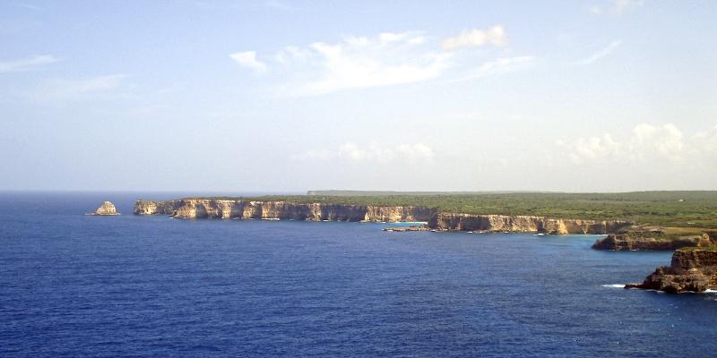
The commune of Anse-Bertrand in northern Grande Terre covers an area of 63.90 km2 atop a limestone plateau marked by a number of changes in elevation and a sculpted coastline with many coves jutting northward between the Caribbean Sea and Atlantic Ocean.
The name of the commune refers both to its dramatic, scalloped contours (“anse” meaning “cove”), and, it is said, to the given name of the first fisherman to settle here, Bertrand Patternait.
Initially considered to be not particularly fertile, the land for several hundred years was primarily the refuge of Caribbean Indians. Arriving in about 1000 C.E. on large gumwood canoes from what is now known as South America, the Caribbean people were warriors. Armed with bows, lances, wooden clubs, and torches, they frequently proved to be fierce combatants against the Arawak people who preceded them on the island. The Caribbeans lived in villages of thatch-roofed huts with bamboo walls. The male members of the tribe came together to organize tribal life under a central roof structure that could hold up to 120 hammocks. The Caribbean people were adept at farming and fishing. The men burned trees and brush to clear the land, and the women planted it (yams, sweet potatoes, manioc, tobacco, and cotton), and also cooked, wove hammocks, made fishing ropes, and created baskets and pottery to hold food and liquids. They used manioc flour to make cakes, and manioc juice for cooking roots and spices for ragouts. Excellent sailors, the Caribbean people employed various fishing methods, including bow and arrow (close to the surface), lines with hooks made from shells, harpoons (for lobsters), and even tossing piles of a certain type of leaf into the water to paralyze the fish.
In this way, the Caribbean Indians inhabited this region until the arrival of the Europeans in the 17th century. They fled the new occupants, but nevertheless appealed to Governor Charles Houël to allow them to reside on approximately 2,000 hectares near Grande Vigie Point. However, living conditions in this arid landscape were so difficult that by 1730, only about 100 people remained there.
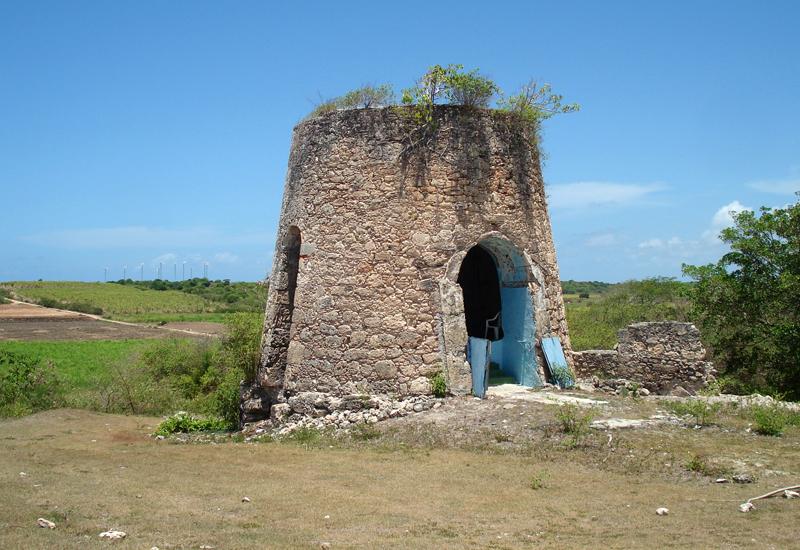
Little by little, their land was ceded to the colonists, who wanted it for growing cotton, a major source of economic activity in the region (in 1790, there were 12 cotton farms), along with sugar cane. However, by the 19th century, sugar was the primary crop; an 1818 census shows 25 sugar plantations here, with over 70% of farmlands reserved for cane. The vestiges of many windmills still present in the commune testify to this rich sugar cane past. However, yields in this region were among the lowest on the island, and the land’s low productivity caused many plantations to send their cane to be milled at the Bellevue and Beauport processing plants in the neighboring commune of Port-Louis. By the late 19th century, the large Beauport sugar factory had acquired most of the sugar cane fields. It ceased operations in 1990.
Agriculture here is still primarily based on sugar cane, whose influence on the economic, social, and cultural life of the commune remains quite significant. Sugar operations have been substantially modernized since the old days. Canes are harvested generally beginning in February. Once harvested, they are quickly transported to factories (mainly the Gardel plant) or distilleries and processed immediately in order to preserve their sucrose content. At the plants they are crushed and transformed into sugar (or rum). Like growers elsewhere on the island, “Ansois” farmers have taken the initiative to preserve their production facilities, while also taking an active interest in new uses for sugar derivatives, in particular “bagasse” (sugar plant residue), which can be used to produce fertilizer, animal feed, energy, and more. Many have also opted to diversify their crops or have turned to cattle raising or truck farming, the latter primarily involving melon cultures.
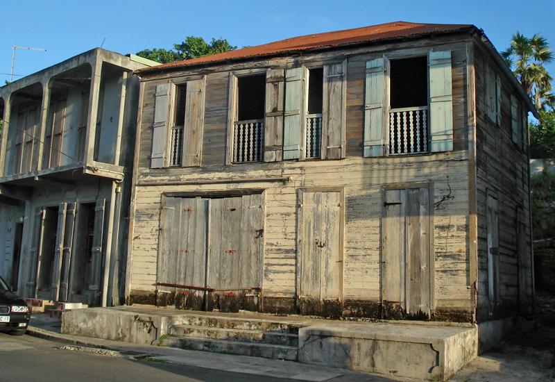
The town of Anse-Bertrand has retained all of its charm. Visitors may admire a number of traditional houses showcasing the artisanal talent of the time, in particular on Avenue Vital Borifax, Rue Schœlcher, and Rue Abbé Grégoire. Heading toward the sea, visitors will pass a bust of Victor Schœlcher, followed by the Eglise Saint-Denis, surrounded by a traditional old cemetery rich in history. The new Anse-Bertrand Multimedia facility is slated to be built nearby. Further on, across from the War Memorial, sit the neoclassical Town Hall and beautiful library buildings. The market structure, freshly repainted by a team of motivated Ansois youth, welcomes a few vegetable and spice vendors. Further north, Ravine Sable (“Sand Ravine”), which was recently developed to add a promenade and shade structures, follows the curves of the wave-battered seafront, leading to a small, sheltered fishing port. Rue Joseph Ignace leads to the Eclipse village green, where traditional craft fairs and many sporting and cultural events take place. Rue Armand Budan (19th-century painter, photographer, and native of Anse-Bertrand) leads to Rue Moulin de Grands Fonds and the windmill of that name.
Tour of Anse-Bertrand
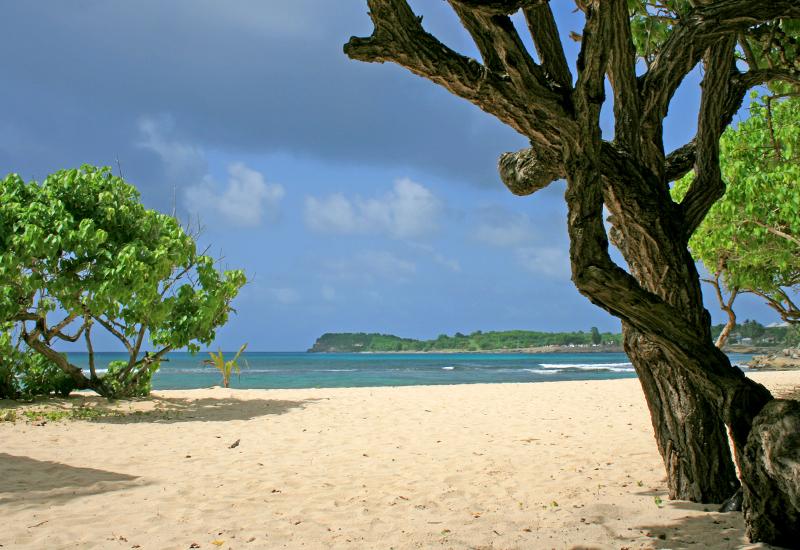
From steep cliffs overhanging raging seas and enchanting fine-sand beaches, to arid lands covered with hardy shrubs, to bucolic sugar cane fields, nature in Anse-Bertrand has remained raw and unspoiled. Visitors may best explore it at a slow walking pace, experiencing its magical appeal in a symphony of intertwining colors, sounds, and smells that stimulate the senses.
Land of legend, Anse-Bertrand has spawned a great deal of folklore inspired by its majestic landscape. Local inhabitants may still recount the myth of “Trou à Man Coco,“ exaggerate the tenacity of the cursed fig tree—which grows straight out of a stone windmill—or comment on the past intrigues of the Mahaudière plantation.
The shoreline is riddled with coves (Anse à la Barque, Anse à Tortues, Anse Pistolet, etc.) and cliffs, from which exceptional panoramic views may be enjoyed. Hike the Trace des Falaises (“Cliff Trace”) from Mahaudière plantation to Porte d’Enfer (“Gates of Hell”), with its lagoon and famous “Trou de Madame Coco.“ Take highway D 122 to magnificent Pointe de la Grande Vigie, the commune’s northernmost point, and return via a series of small coves huddled against rocky outcroppings, where visitors may enjoy breathtaking views before arriving at their ultimate destination: beautiful Anse Laborde beach. Cyclists may enjoy the ride from Chapelle Beach to Anse Colas Cove. A circuit takes hikers to Plate Point.
These outings will expose visitors to the native vegetation of Ansois shores: raisinier (“seagrape”) trees; catalpas, with their heart-shaped leaves and yellow flowers (not to be confused with the poisonous Manicheel tree); “poirier-pays” (“pink trumpet flower”) trees; frangipani trees; and, in mangrove environments, the rhizophora mangle—known as the red mangrove—along with black mangroves and philodendron giganteum.
Away from the coastal wilderness, far from the sea and its furies, visit the quiet countryside and its villages to encounter older residents, their faces lined with years of toil, cultivating creole gardens or chatting in the shade of a mango tree. In this rural landscape with a turbulent past, experience the ochre light emanating from the façades of traditional huts, sparks of gold reflecting off fields undulating in the wind, the wafting aromas of spicy cooking, the fragrance of freshly cut cane, the bleating of goats…. all blending together in a single harmony to elicit deep emotion.
Further inland, along paths that are sometimes open to motor vehicles, stone windmill towers rise from firm foundations in the midst of former plantations, plunging visitors into the past. Le Mercier, Beaufond, Budan, and Grands Fonds windmills all testify to the commune’s sugar-cane past, jealously guarding the memories of all who built and operated them until the advent of organized, centralized factory milling.
With a population now 5,102 strong, Anse-Bertrand, while maintaining its agricultural identity, has welcomed new economic activities, showcasing the talent of its artisans and developing eco-tourism. Small lodging structures have been created, in perfect harmony with their scenic landscapes. Holiday cottages and bungalows operated by locals or long-term lovers of Guadeloupe, they combine peace and quiet with friendly interaction with hosts, for a deeply satisfactory visit.
Land of champions, the commune has been a strong promoter sports for many decades. It is home to numerous athletic events each year—in particular the “20 km du Nord Grande-Terre” race in October—and is proud to call famous 1998 world champion soccer player Lilian Thuram a native, along with sprinter Christine Arron, winner of multiple titles, and several high-level competitive cyclists, who have brought, and continue to bring, glory to the local UVN cycling club.
In addition to athletic facilities across the territory, the commune has the only horse track on the island, Hippodrome Saint-Jacques, and is actively developing water sports, having recently hosted a world championship surfing event.
Land of encounters, Anse-Bertrand lives up to its reputation. Here, people love to converse, get together, and tackle new projects, and there is no shortage of opportunities for sharing moments of jubilation, partying to the beat of the traditional “ka” drum, taking part in athletic challenges, attending Pulling Bull contests, or participating in craft fairs where everyone gathers to express his or her talents. Chemin Bleu tourist maps of Guadeloupe and city street maps are available at the Office of Tourism. www.ot-ansebertrand.fr

-
Sightseeing

- South Basse-Terre: Thrilling Sensations in a Tropical Forest Setting
- Côte-sous-le-vent: Artisanal Craftsmanship and Spectacular Diving
- North Basse-Terre: Glimmers of Sugar Cane and Marine Breezes
- North Grande-Terre: Stunning Landscapes and Cane Traditions
- East Grande-Terre: Thrilling Emotions on Land and Sea
- West Grande-Terre: Colors, Flavors, and a Glorious Past
- Les Saintes: Marine Breezes and Sweet Relaxation
- Marie-Galante: Non-Stop Charm in the Land of Sugar
- La Désirade: Untouched Landscapes, Shared Emotions
-
Tourist
-
Communes

- Les Abymes
- Anse-Bertrand
- Baie-Mahault
- Baillif
- Basse-Terre
- Bouillante
- Capesterre-Belle-Eau
- Capesterre-de-Marie-Galante
- Deshaies
- La Désirade
- Le Gosier
- Gourbeyre
- Goyave
- Grand-Bourg
- Lamentin
- Morne-à-l'Eau
- Le Moule
- Petit-Bourg
- Petit-Canal
- Pointe-à-Pitre
- Pointe-Noire
- Port-Louis
- Saint-Claude
- Sainte-Anne
- Sainte-Rose
- Saint-François
- Saint-Louis
- Terre-de-Bas
- Terre-de-Haut
- Trois-Rivières
- Vieux-Fort
- Vieux-Habitants
Downloadable
-
See all places

- “La Renaissance” movie theater - Pointe-à-Pitre
- 1st and 2nd Carbet Waterfalls - Capesterre Belle-Eau
- 3rd Carbet Waterfall - Capesterre Belle-Eau
- 5 February 1967, Square - Petit-Canal
- 9 August 1882 Square - Terre-de-Bas
- Acomat Falls - Pointe-Noire
- Acomat Point - Trois-Rivières
- Adventitious Church of Vieux-Habitants - Vieux-Habitants
- Airfield - Saint-François
- AIslands Cove - Sainte-Rose
- Alexina Garden - Le Gosier
- Allée de la Liberté - Bouillante
- Allée Dumanoir - Capesterre Belle Eau
- Allée Dumanoir Recreational Area - Capesterre Belle-Eau
- Almond Tree Beach - Sainte-Rose
- Amédée Detreaux Velodrome - Baie-Mahault
- Amédée Fengarol Primary School - Capesterre Belle-Eau
- Amerindian Garden of the Edgar Clerc Museum - Le Moule
- Amerindian Heritage - Baillif
- Ancien monastère Saint-Antoine - Basse-Terre
- Anse à Sable Beach - Bouillante
- Anse Colas - Anse-Bertrand
- Anse Crawen - Terre-de-Haut
- Anse de Pigeon - Bouillante
- Anse du Fond Curé - Terre-de-Haut
- Anse du Souffleur beach - Port-Louis
- Anse Duché Beach - Bouillante
- Anse Dupuy - Vieux-Fort
- Anse Feuillard Cove - Capesterre de Marie-Galante
- Anse Laborde Beach - Anse-Bertrand
- Anse-Bertrand - 5 276 Hab.
- Aquaculture Park - Pointe-Noire
- Aquarium - Le Gosier
- Arboretum - Trois-Rivières
- Assainissement district - Pointe-à-Pitre
- Audoin River - Le Moule
- Babin Beach - Morne-A-l'Eau
- Back Cove - Terre-de-Bas
- Bagasse-Coal Plant - Le Moule
- Baie de Blachon - Lamentin
- Baie-Mahault - 31 069 Hab.
- Baillif - 5 801 Hab.
- Balloon Bridge - Sainte-Anne
- Banana Wood Waterfall - Lamentin
- Basse-Terre - 11 049 Hab.
- Battery Point - Deshaies
- Beach of the Other Side - Le Moule
- Beaufond Windmill - Anse-Bertrand
- Beauplaisir Windmill - Port-Louis
- Beauport Guadeloupe - Port-Louis
- Beautiran Path - Petit-Canal
- Beautiran Site - Petit-Canal
- Bébian school - Pointe-à-Pitre
- Begging Mayor Square - La Désirade
- Belin windmill - Port-Louis
- Belmont Plantation Slave Dungeon - Trois-Rivières
- Bernard Refinery - Capesterre de Marie-Galante
- Bétin plantation - Port-Louis
- Bettino Lara Media Library - Basse-Terre
- Beuthier windmill - Port-Louis
- Bézard windmill - Capesterre de Marie-Galante
- Bielle Distillery - Grand-Bourg
- Big Basin - Saint-Louis
- Big Hill - Deshaies
- Big Hole Pond - Terre-de-Bas
- Big Mouth Chasm - Saint-Louis
- Big Pond - Capesterre Belle Eau - Capesterre Belle-Eau
- Big Sand Beach - Sainte-Anne
- Bik-Kontakaz - Sainte-Anne
- Bisardy Plantation - Gourbeyre
- Bishopric - Basse-Terre
- Blackberry Bush Cove - Terre-de-Bas
- Blessed Savior Cove - Capesterre Belle-Eau
- Blondeau Plantation - Vieux-Fort
- Blonzac Aquatic Garden - Goyave
- Blower Beach - La Désirade
- Blue Pool - Gourbeyre
- Boat Cove - Saint-François
- Boat Cove - Bouillante
- Boat Cove - Vieux-Habitants
- Bois-Debout Plantation - Capesterre Belle-Eau
- Bologne Distillery - Basse-Terre
- Botanical Garden - Basse-Terre
- Botanical Garden - Deshaies
- Bouillante - 7 528 Hab.
- Bras du Fort Falls - Goyave
- Budan Windmill - Anse-Bertrand
- Bust of Augustin Gourbeyre - Gourbeyre
- Bust of Delgrès - Saint-François
- Bust of Delgrès - Deshaies
- Bust of Delgrès - Goyave
- Bust of Delgrès - Vieux-Habitants
- Bust of Félix Eboué - Pointe-à-Pitre
- Bust of Félix Eboué - Sainte-Rose
- Bust of General Frébault - Pointe-à-Pitre
- Bust of Jean Louis - Goyave
- Bust of Louis Delgrès - Pointe-Noire
- Bust of Lucien Bernier - Saint-François
- Bust of Victor Schœlcher - Morne-A-l'Eau
- Buste de Félix Eboué - Morne-A-l'Eau
- Cadoue Windmill - Anse-Bertrand
- Calvary Nature Park - Le Gosier
- Camille Soprann Square - Saint-Louis
- Camp Jacob - Saint-Claude
- Capès-Dolé Bottling Plant - Gourbeyre
- Capesterre Belle-Eau - 19 315 Hab.
- Capesterre de Marie-Galante - 3 355 Hab.
- Caraïbes Mountains - Vieux-Fort
- Caravelle Beach - Sainte-Anne
- Caravelle Surf Spot - Sainte-Anne
- Caribbean Beach - Pointe-Noire
- Caribbean Mountains - Gourbeyre
- Carmelite Square - Basse-Terre
- Carved Rock Archeological Park - Trois-Rivières
- Casino de Saint-François - Saint-François
- Cassava Factory - Sainte-Anne
- Cassava Factory - Petit-Bourg
- Cayenne Cemetery - Saint-François
- Cemetery - Morne-A-l'Eau
- Cemetery - Pointe-à-Pitre
- Cemetery Square - Le Moule
- Center for Embroidery and Textile Arts - Vieux-Fort
- Central Covered Market - Basse-Terre
- Central Market - Pointe-à-Pitre
- Champ d’Arbaud Parade Grounds - Basse-Terre
- Changy Hindu Temple - Capesterre Belle-Eau
- Chapel Beach - Anse-Bertrand
- Chapel Our Lady of Charity - Le Moule
- Chapelle Notre Dame de Guadeloupe - Saint-Claude
- Chapelle Notre Dame du Phare - La Désirade
- Chapelles - Port-Louis
- Chapp House - Basse-Terre
- Chevalier de Saint-Georges Square - Basse-Terre
- Christ the King Church at Les Mangles - Petit-Canal
- Church of Notre Dame du Bon Port - Petit-Bourg
- Church of Our Lady of Good Help - Port-Louis
- Church of Saint Phillip and Saint John - Petit-Canal
- Church of Saint-Louis - Bouillante
- Church of Sainte-Anne - Goyave
- Church of Sainte-Thérèse de l'Enfant Jésus - Petit-Bourg
- Church of St. John the Baptist - Le Moule
- Church of St. John the Baptist - Baie-Mahault
- Church of St. Peter and St. Paul - Deshaies
- Church of the Immaculate Conception - Les Abymes
- Church of the Immaculate Conception - Grand-Bourg
- Church Square - Saint-François
- Church Square - Saint-Louis
- Cicéron Alley - Basse-Terre
- Cimetière des Indiens - Saint-François
- Ciné-Théâtre - Lamentin
- City Hall - Les Abymes
- City Hall - Basse-Terre
- City Hall - Vieux-Habitants
- City Pavilion - Pointe-à-Pitre
- Claire Fontaine Plantation - Baillif
- Cliff Trace - Anse-Bertrand
- Cliffs - Vieux-Fort
- Cluny Beach - Sainte-Rose
- Cœur de Bouillante - Bouillante
- Coffee Museum - Vieux-Habitants
- Colo Pool - Petit-Bourg
- Colonial House - Le Moule
- Column and Bust of Marianne - Bouillante
- Commemorative plaque in homage to Justin Catayée - Pointe-à-Pitre
- Courthouse - Basse-Terre
- Crab House - Le Moule
- Crawfish Cascade - Petit-Bourg
- Crazy Cove Beach - Grand-Bourg
- Damencourt Nature Park - Le Moule
- Damoiseau Distillery - Le Moule
- Dampierre windmill - Le Gosier
- Datcha Beach - Le Gosier
- Delgrès Stele - Morne-A-l'Eau
- Departmental Residence - Le Gosier
- Descamps House, Birmingham Plantation - Baie-Mahault
- Deshaies - 4 215 Hab.
- Deshaies Cove - Deshaies
- Deshaies Diving - Deshaies
- Desmarais Distillery - Saint-Claude
- Dévarieux windmill - Petit-Canal
- Deville-Maisoncelle Path - Petit-Canal
- Diavet and Bwé ponds - Le Gosier
- Distillerie Bellevue - Capesterre de Marie-Galante
- Diving - Bouillante
- Dolé Public Pool - Gourbeyre
- Domaine de la Lise - Bouillante
- Domaine de St-Paul - Sainte-Anne
- Du Mont Cove - Le Gosier
- Duval Site - Petit-Canal
- Eco-museum of Guadeloupe - Sainte-Rose
- Eco-Touristic Park of Trois-Pointes - Vieux-Fort
- Edgar Clerc Museum - Le Moule
- Eiffel Bridge - Pointe-Noire
- Eiffel-style Bridges - Goyave - Goyave
- Eloi Germain Interpretive Garden - Terre-de-Bas
- Escape Hill - Sainte-Anne
- Escaped Slave Memorial - Sainte-Anne
- Espace Thermo-Ludique René Toribio - Lamentin
- Espace Wizosky - Le Moule
- Fanfan Beach - La Désirade
- Father Labat Tower - Baillif
- Fatima Chapel - Le Moule
- Félix Eboué Square - Capesterre de Marie-Galante
- Ferry Battery - Deshaies
- Ferry Cove - Deshaies
- Feuillère Beach - Capesterre de Marie-Galante
- Fidelin Pond - Les Abymes
- Fiesque Duchesne Stadium - Baie-Mahault
- Fifi Beach - La Désirade
- Fig Tree Beach - Terre-de-Haut
- Fishing and Pleasure Boat Port - Sainte-Rose
- Fishing and Pleasure Boat Port - Sainte-Rose
- Fishing Port - Saint-François
- Fishing Port - Le Moule
- Fishing Port - Deshaies
- Folle-Anse Cargo Port - Grand-Bourg
- Fontaine Adolphine - Saint-Claude
- Footbridge of the Two Banks - Le Moule
- Former Cotton Mill - La Désirade
- Former Dorot Distillery - Saint-Louis
- Former Duval Refinery - Petit-Canal
- Former Fidelin Pottery Works - Terre-de-Bas
- Former Grosse Montagne Sugar Plant - Lamentin
- Former health care center and maternity hospital - Port-Louis
- Former Law Courts - Port-Louis
- Former Leper Colony - La Désirade
- Former Marquisat Factory - Capesterre Belle-Eau
- Former Power Plant: La Friche - Baie-Mahault
- Former Prison - Petit-Canal
- Former Prison - Goyave
- Former Prison - Anse-Bertrand
- Former Rex movie theater - Port-Louis - Port Louis
- Former Saint-Jacques plantation - Saint-François
- Former Weather Station - La Désirade
- Fort Fleur d'Epée - Le Gosier
- Fort l'Olive - Vieux-Fort
- Fort Louis - Le Gosier
- Fort Louis Delgrès - Basse-Terre
- Fort Napoleon - Terre-de-Haut
- Fortune Islet - Goyave
- Fountain - Gourbeyre
- Fresque murale du lycée de Baimbridge - Les Abymes
- Gadet Lookout - Deshaies
- Galion Falls - Saint-Claude
- Galion Gorges - Saint-Claude
- Gardel Factory - Le Moule
- Gaschet Ravine - Petit-Canal
- Gates of Hell - Le Moule
- Gates of Hell - Anse-Bertrand
- Gédéon-Bambou park - Morne-A-L'Eau
- General Council Building - Basse-Terre
- Gertrude Square - Petit-Bourg
- Gerty Archimède Museum - Basse-Terre
- Gerville-Réache Secondary School - Basse-Terre
- Getz Plantation - Vieux-Habitants
- Gilles Floro Culture House - Gourbeyre
- Girard windmill - Petit-Canal
- Giratoire “Les amarreuses de Jabrun” - Baie-Mahault
- Gissac windmill - Sainte-Anne
- Godet windmill - Petit-Canal
- Good Mother Factory - Sainte-Rose
- Gourbeyre - 7 986 Hab.
- Gourd Cove Beach - Saint-François
- Goyave - 7 761 Hab.
- Grand Cove Beach - Deshaies
- Grand Cul-de-Sac Marin Bay - Sainte-Rose
- Grand Cul-de-Sac Marin Natural Preserve - Baie-Mahault
- Grand Pierre windmill - Saint-Louis
- Grand-Anse Beach - Terre-de-Bas
- Grand-Bourg - 5 409 Hab.
- Grand-Bourg Beach - Grand-Bourg
- Grand-Point Battery - Trois-Rivières
- Grande Anse Sugar Refinery - Grand-Bourg
- Grande Rivière à Goyaves - Lamentin
- Grande Vigie Point - Anse-Bertrand
- Grande-Anse Battery - Trois-Rivières
- Grandfond Windmill - Anse-Bertrand
- Grands Fonds - Le Gosier
- Grands Fonds - Sainte-Anne
- Grands Fonds - Le Moule
- Grands Fonds - Les Abymes
- Great Cove Beach - Trois-Rivières
- Greenery Point - Le Gosier
- Guyonneau Plantation - Deshaies
- Habitation Desmarets - Basse-Terre
- Habitation La Mahaudière - Anse-Bertrand
- Harbor Terminal - Saint-François
- Helleux Surf Spot - Sainte-Anne
- Henry Sidambarom Stela - Capesterre Belle-Eau
- Heritage House - Basse-Terre
- Hiking Trails - Gourbeyre
- Hiking Trails - La Désirade
- Hiking Trails - Terre-de-Bas
- Hiking Trails - Pointe-Noire
- Hindu temple - Les Abymes
- Hindu Temple of Gaschet - Port-Louis
- Hot baths of Matouba - Saint-Claude
- House of Bananas - Trois-Rivières
- House of Cacao - Pointe-Noire
- House of the Elders - Basse-Terre
- Hummingbird Point - La Désirade
- Ilet Boissard - Pointe-à-Pitre
- Ilet Caret - Sainte-Rose
- Ilets de Carénage, Ilet Blanc, Ilet la Biche - Sainte-Rose
- Indian Memorial - Saint-François
- Information Office and Bust of Louis Delgrès - Gourbeyre
- International Golf Course - Saint-François
- Isle of the Goats - Terre-de-Haut
- Jardin de la Rencontre - Capesterre Belle-Eau
- Jérôme Cléry Municipal Auditorium - Basse-Terre
- Jolan Woods Beach - Sainte-Anne
- Karukera Rum Distillery - Capesterre Belle-Eau
- Karuptures – Totem, Work of Edgar Negret - Lamentin
- Karuptures, Lumi-Naissance - Lamentin
- Karuptures, Madonna and Child, work of Leopoldo Maler - Lamentin
- Karuptures, Physiochromie du Lamentin, work of Carlos Cruz Diez. - Lamentin
- Karuptures, Tribute to the abolition of human slavery, work of Erik Dietman - Lamentin
- Kreol West Indies - Grand-Bourg
- Kreol West Indies Museum Space - Saint-François
- L’Herminier House - Pointe-à-Pitre
- L’il Cove Beach - Pointe-Noire
- La Coulisse - Trois-Rivières
- La Darse - Pointe-à-Pitre
- La Désirade - 1 549 Hab.
- La Grivelière Plantation - Vieux-Habitants
- La Lézarde Falls - Petit-Bourg
- La Lézarde River - Petit-Bourg
- La Mahaudière Windmill - Anse-Bertrand
- La Marianne - Pointe-Noire
- La Pastorale House - Trois-Rivières
- La Ramée Plantation - Sainte-Rose
- La Rose Plantation - Goyave
- Ladder Cove - La Désirade
- Lagoon Beach - Saint-François
- Lake Gaschet - Port-Louis
- Lamentin - 16 313 Hab.
- Latchmansing temple - Shiva temple - Saint-François
- Laura Flessel Sports Complex - Petit-Bourg
- Le Chameau - Terre-de-Haut
- Le Gosier - 27 920 Hab.
- Le Gosier Islet - Le Gosier
- Le Moule - 22 404 Hab.
- Leeward Coast House - Vieux-Habitants
- Leroux Beach - Deshaies
- Les Abymes - 56 581 Hab.
- Letaye Dam - Le Moule
- Lethière Street - Sainte-Anne
- Lethière Traffic Circle - Sainte-Anne
- Liberty Square - Basse-Terre
- Lighthouse - Vieux-Fort
- Little Cove Beach - Capesterre de Marie-Galante
- Little River Beach - La Désirade
- Loiseau Plantation - Vieux-Habitants
- Louis Delgrès Stela - Saint-Claude
- Lovers’ Pool - Gourbeyre
- Lubeth windmilll - Petit-Canal
- Lycée Carnot - Pointe-à-Pitre
- Maison de la Forêt - Petit-Bourg
- Maison de la Mangrove - Les Abymes
- Maison Monnerville - Morne-A-l'Eau
- Maisons typiques - Anse-Bertrand
- Malendure Beach - Bouillante
- Mambia beach - Sainte-Rose
- Mamelles Zoological Park - Bouillante
- Man Réaux Mall - Pointe-à-Pitre
- Mangrove Swamp - Le Gosier
- Mangrove Swamps - Petit-Canal
- Mangrove Swamps - Saint-Louis
- Mangrove-la Ka - Port-Louis
- Manioc Factory - Deshaies
- Marigot Bay - Terre-de-Haut
- Marina - Saint-François
- Marina - Le Gosier
- Marina - Pointe-à-Pitre
- Marina traffic circle - Pointe-à-Pitre
- Marius Chipotel Square - Sainte-Anne
- Market - Sainte-Anne
- Market - Capesterre Belle-Eau
- Marquisat de Sainte-Marie Estate - Capesterre Belle-eau
- Marshes - Port-Louis
- Massabielle church - Pointe-à-Pitre
- Massif de la Madeleine - Trois-Rivières
- Matouba Factory - Saint-Claude
- Matouba Falls - Saint-Claude
- Maurice Cove - Petit-Canal
- Max Mathurin Stela - La Désirade
- Mayoumbé windmill - Saint-Louis
- Mays Cove - Saint-Louis
- Médiathèque Ernest J. Pépin - Lamentin
- Mémorial ACTe - Pointe-à-Pitre
- Mémorial aux victimes de 1925 - Petit-Canal
- Memorial to the First Day - Pointe-à-Pitre
- Memorial to the Sacrifice of Delgrès - Les Abymes
- Memorial to the victims of May 1967 - Pointe-à-Pitre
- Memorial to Victor Schoelcher - Vieux-Habitants
- Mémorial Victor Schœlcher - La Désirade
- Memorial Wall - Les Abymes
- Ménard windmill - Saint-Louis
- Michaux windmill - Petit-Canal
- Mills - Saint-François
- Moko Bridge - Lamentin
- Moko Bridge - Sainte-Rose
- Montal Beach - Le Moule
- Montebello Distillery - Petit-Bourg
- Monument aux morts - Anse-Bertrand
- Monument aux morts (“War Memorial”) - Lamentin
- Monument of the Eternal Flame to the Unknown Slave - Petit-Canal
- Monument to Christopher Columbus - Capesterre Belle-Eau
- Monument to Freedom - Petit-Canal
- Moreau Falls - Goyave
- Moreau Interpretive Trail - Goyave
- Morel Trace - Terre-de-Haut
- Morne Calvaire - Les Abymes
- Morne de la Mémoire - Les Abymes
- Morne-à-l'Eau - 17 504 Hab.
- Morne-Rouge School - Sainte-Rose
- Murat Plantation and Eco-Museum of Marie-Galante - Grand-Bourg
- Musée de la graine - Trois-Rivières
- Museum of Costumes and Traditions - Le Gosier
- Museum of Days Gone By - Petit-Canal
- National Theater - Basse-Terre
- Nature Park - Petit Canal
- Neg Mawon Stela - Petit-Bourg
- Néron Plantation - Le Moule
- Night Market - Saint-François
- Night Market - Sainte-Anne
- Night Market - Petit-Bourg
- Notre Dame du Mont-Carmel Church - Basse-Terre
- Notre Dame Sanctuary - Deshaies
- Notre-Dame de Guadeloupe Cathedral - Basse-Terre
- Novilos Courtyard - Basse-Terre
- Nozières Bridge - Saint-Claude
- Oceanfront - Basse-Terre
- Old Mill Trace - Petit-Canal
- Old Town Hall - Saint-Claude
- Olive Bay - Saint-François
- Olympe Victor Auguste Combes Giratoire - Lamentin
- Open-Air Theater - Lamentin
- Oratory - Goyave
- Ornithological site of Ravine Sable - Anse-Bertrand
- Osange Talis Gane Multimedia Library - Sainte-Anne
- Ouatibi Tibi Park - Le Moule
- Our Lady of Calvary Chapel - La Désirade
- Our Lady of Good Help Church - La Désirade
- Our Lady of Good Hope - Morne-A-l'Eau
- Our Lady of Jarry Chapel - Baie-Mahault
- Our Lady of the Assumption Church - Terre-de-Haut
- Our Lady of the Assumption Church - Pointe-Noire
- Our Lady of the Assumption Church - Trois-Rivières
- Palace of Culture Felix Proto - Les Abymes
- Palais d'Orléans (Prefecture Building) - Basse-Terre
- Paradise Pool - Capesterre Belle-Eau
- Paradoxe Croisières - Saint-François
- Parc de la Source - Bouillante
- Parc de la Verdure - Lamentin
- Parc National - Saint-Claude
- Paul Aubin windmill - Port-Louis
- Paul Lacavé Memorial - Capesterre Belle-Eau
- Paul Mado Multimedia Library - Baie-Mahault
- Paved Path Ravine - Le Gosier
- Pearl Beach - Deshaies
- Pebble Beach - La Désirade
- Pebble Cove - La Désirade
- Perrin Canal - Les Abymes
- Petit Carbet Plantation-Refinery - Trois-Rivières
- Petit Cul-de-Sac Marin - Petit-Bourg
- Petit-Bourg - 24 507 Hab.
- Petit-Canal - 8 262 Hab.
- Petit-Havre Beach - Le Gosier
- Petite Anse Cove - Terre-de-Bas
- Petite Terre - La Désirade
- Petite-Anse beach - Bouillante
- Pichon Square - Basse-Terre
- Pigeon Isles - Bouillante
- Place Camille Desmoulins - Pointe-à-Pitre
- Place de la Mairie - Bouillante
- Place de la Victoire - Pointe-à-Pitre
- Place Frédéric Jalton - Les Abymes
- Place Gerty Archimède - Morne-A-l'Eau
- Place Gourbeyre - Pointe-à-Pitre
- Plage de Grande-Anse - Terre-de-Haut
- Plage de l'Anse Canot - Saint-Louis
- Plage de la Porte d'Enfer - Anse-Bertrand
- Plage de Moustique - Saint-Louis
- Plaine de Grippon - Morne-A-l'Eau
- Plaisance windmill - Port-Louis
- Plantation Grand Café - Capesterre Belle-Eau
- Plate Point Trail - Anse-Bertrand
- Plateau du Palmiste - Gourbeyre
- Platform of Beron (Bonne Mère) - Sainte-Rose
- Point Bleu Soleil - Gourbeyre
- Point Helleux Beach - Sainte-Anne
- Pointe Allègre - Sainte-Rose
- Pointe des Châteaux - Saint-François
- Pointe-à-Pitre - 16 427 Hab.
- Pointe-Noire - 6 519 Hab.
- Poisson Distillery - Grand-Bourg
- Pôle Caraïbes Airport - Les Abymes
- Polishing block of Dindé - Sainte-Rose
- Pompierre Beach - Terre-de-Haut
- Pond Beach - Vieux-Habitants
- Pond Trace Hiking Trail - Capesterre Belle-Eau
- Ponds - Anse-Bertrand
- Pont de la rivière du Plessis - Baillif
- Port - Petit-Canal
- Port - Port-Louis
- Port - La Désirade
- Port - Capesterre de Marie-Galante
- Port - Grand-Bourg
- Port - Saint-Louis
- Port - Baie-Mahault
- Port de Vieux-Bourg - Morne-A-l'Eau
- Port Galbas - Sainte-Anne
- Port of Jarry - Baie-Mahault
- Port-Louis - 5 867 Hab.
- Pottery Kiln - Trois-Rivières
- Poyen windmill - Petit-Canal
- Presbytery - Port-Louis
- Primary School “Alice Delacroix“ - Petit Canal
- Public Park and Fountain - Trois-Rivières
- Pulling bull contests - Anse-Bertrand
- Pulling bull contests - district of Guéry - Anse-Bertrand
- Pulling Bulls - Baie-Mahault
- Punch Pond and Pirogue Factory - Grand-Bourg
- Rambouillet Cross - Port-Louis
- Raoul Georges Nicolo Media Library - Le Gosier
- Ravine Sable (Sand Ravine) - Anse-Bertrand
- Red Bridge - Deshaies
- Red Head - Terre-de-Haut
- Regional Council of Guadeloupe - Basse-Terre
- Rémy Nainsouta Center - Pointe-à-Pitre
- René Boisneuf Multimedia Library - Pointe-à-Pitre
- Réserve Cousteau - Bouillante
- Rifflet Beach - Deshaies
- Ring of Slavery - Pointe-à-Pitre
- Rivière de la Coulisse - Trois-Rivières
- Rocroy Beach - Vieux-Habitants
- Rodriguez Cove - Terre-de-Haut
- Rooster Cove - Saint-Louis
- Roseau Beach - Capesterre Belle-Eau
- Rotours Canal - Morne-A-l'Eau
- Roussel-Trianon Sugar Planation - Grand-Bourg
- Rue Achille-René Boisneuf - Pointe-à-Pitre
- Rue Frébault - Pointe-à-Pitre
- Rum Museum - Sainte-Rose
- Sailing Center - Goyave
- Saint Anne Church - Capesterre de Marie-Galante
- Saint Bernadette Church of Grands Fonds - Sainte-Anne
- Saint Denis Church - Anse-Bertrand
- Saint Dominic Church - Baillif
- Saint Hyacinth Church - Capesterre Belle-Eau
- Saint Rose of Lima Church - Sainte-Rose
- Saint-Albert Church - Vieux-Fort
- Saint-André church - Morne-A-l'Eau
- Saint-Augustin Church - Saint-Claude
- Saint-Charles Borromée Church - Gourbeyre
- Saint-Claude - 10 587 Hab.
- Saint-Felix Beach - Le Gosier
- Saint-François - 14 609 Hab.
- Saint-Jacques Racetrack - Anse-Bertrand
- Saint-John Perse Museum - Pointe-à-Pitre
- Saint-Joseph Church - Vieux-Habitants
- Saint-Joseph de Cluny Day School - Pointe-à-Pitre
- Saint-Louis - 2 540 Hab.
- Saint-Louis Beach - Saint-Louis
- Saint-Louis Church - Le Gosier
- Saint-Louis Plantation - Baillif
- Saint-Nicolas Church - Terre-de-Bas
- Saint-Pierre and Saint-Paul church - Pointe-à-Pitre
- Sainte-Anne - 25 037 Hab.
- Sainte-Anne Church - Sainte-Anne
- Sainte-Claire Beach - Goyave
- Sainte-Rose - Sainte-Rose
- Sainte-Trinité Church - Lamentin
- Saintes Bay - Terre-de-Haut
- Salabouelle Cove - Le Moule
- Saline Beach - Le Gosier
- Saltwork Beach - Le Gosier
- Salty Cove - Capesterre Belle-Eau
- Sans Fenêtre Windmill - Anse-Bertrand
- Sarrault Square - Petit-Bourg
- Schœlcher Museum - Pointe-à-Pitre
- Schœlcher Square - Sainte-Anne
- Sé la vi la ki pli bèl (“Life is Beautiful”) Sculpture - Basse-Terre
- Seashore - Pointe-Noire
- Seaside cemetery - Port-Louis
- Sens River Beach - Gourbeyre
- Sens River Marina - Gourbeyre
- Sentier de l'Acomat - Trois-Rivières
- Sentier Lavolvaine - Port-Louis
- Séo Pond - Sainte-Anne
- Séverin Estate - Sainte-Rose
- Shell House - Basse-Terre
- Shoreline Trail - Le Gosier
- Shrine of Our Lady of Tears - Pointe-Noire
- Silver Basin Port - Pointe-Noire
- Simaho Beach - Vieux-Habitants
- Simonière pond - Saint-François
- Site of the 1962 Boeing Jet Crash - Deshaies
- Slave Cemetery - Capesterre Belle-eau
- Slave Memorial - Saint-François
- Slave Steps - Petit-Canal
- Small Fort - Le Moule
- Social Hall - Lamentin
- Sofaïa Sulfur Springs - Sainte-Rose
- Sonis Cultural Center - Les Abymes
- Source de Poucet - Le Gosier
- Source de Thomas - Bouillante
- Source of the Rivière Rouge - Saint-Claude
- Sports Center - Le Gosier
- Spot de Damencourt - Le Moule
- Spot de La Bouelle - Le Moule
- Spot de La Chapelle - Anse-Bertrand
- Spot de La Station - Le Moule
- Square Christophe Colomb (Christopher Columbus Square) - Baie-Mahault
- Square Guy Cornély - Les Abymes
- Statue of Gandhi - Saint-François
- Statue of Joseph Ignace - Les Abymes
- Statue of Martin Luther King - Saint-François
- Statue of Nelson Mandela - Les Abymes
- Statue of the mulatto woman, “Solitude” - Les Abymes
- Statue of Vélo, the King of ka - Pointe-à-Pitre
- Sucrerie de Nogent - Sainte-Rose
- Sugar Cane Tradition - Baie-Mahault
- Sugar Loaf Mountain - Terre-de-Haut
- Sylvathèque - Gourbeyre
- Tabarin Cove Beach - Le Gosier
- Taliseronde Beach - Capesterre de Marie-Galante
- Tarare Cove - Saint-François
- Teddy Riner Square - Vieux-Habitants
- Terre-de-Bas - 1 097 Hab.
- Terre-de-Haut - 1 699 Hab.
- The Carénage district - Pointe-à-Pitre
- The district of “Grand-Baie“ - Le Gosier
- The Former Arsenal - Basse-Terre
- The former City Hall - Les Abymes
- The former Darboussier factory - Pointe-à-Pitre
- The former factory in Blanchet - Morne-à-l'Eau
- The former factory in Pointe-à-Retz - Morne à l'Eau
- The Galleries - Capesterre de Marie-Galante
- The Geothermal Plant - Bouillante
- The Law Courts - Pointe-à-Pitre
- The Mutual Insurance Building - Pointe-à-Pitre
- The New Courthouse - Pointe-à-Pitre
- The Observer - Deshaies
- The Old Municipal Jail - Bouillante
- The Old Town Hall - Bouillante
- The Pointe des Châteaux Cross - Saint-François
- The Port - Petit-Bourg
- The Port - Goyave
- The Rotunda - Saint-François
- The Sulfurer Volcano - Saint-Claude
- Three Bridges - Sainte-Anne
- Three Islands Beach - Grand-Bourg
- Three-Horn Falls - Sainte-Rose
- Tillet Beach - Deshaies
- Tourist House - Saint-Claude
- Town Beach - Sainte-Anne
- Town Hall - Sainte-Anne
- Town Hall - Morne-A-l'Eau
- Town Hall - Port-Louis
- Town Hall - Grand-Bourg
- Town Hall - Capesterre de Marie-Galante
- Town Hall - Petit-Bourg
- Town Hall - Sainte-Rose
- Town Hall - Lamentin
- Town Hall - Pointe-Noire
- Town Hall - Capesterre Belle-Eau
- Town Hall - Trois-Rivières
- Town Hall - Baillif
- Town Hall - Saint-Claude
- Town Hall - Baie-Mahault
- Town Hall - Petit-Canal
- Town Hall Square - Terre-de-Haut
- Town Hall Square - Petit-Bourg
- Tradewinds Beach - Le Moule
- Traditional Houses - Petit-Bourg
- Traditional Houses - Pointe-Noire
- Traditional Houses - Basse-Terre
- Trois-Rivières - 8 625 Hab.
- Typical houses - Port-Louis
- Typical houses - Pointe-à-Pitre
- Typical houses - Morne-à-l'Eau - Morne à l'Eau
- Valombreuse Gardens - Petit-Bourg
- Vanibel Estate - Vieux-Habitants
- Vernou Residential Quarter - Petit-Bourg
- Viard Beach - Petit-Bourg
- Viard River - Sainte-Rose
- Victor Schœlcher Column - Anse-Bertrand
- Victor Schœlcher Square - Grand-Bourg
- Victor Servan Soliman Nature Park - Petit-Bourg
- Vieux-Bourg church - Morne-A-l'Eau
- Vieux-Fort - 1 897 Hab.
- Vieux-Fort Beach - Saint-Louis
- Vieux-Habitants - 7 602 Hab.
- Volcanology and Seismology Laboratory - Gourbeyre
- Walking and Hiking - Bouillante
- War Memorial - Sainte-Anne
- War Memorial - Petit-Canal
- War Memorial - Port-Louis
- War memorial - Pointe-à-Pitre
- War Memorial - Les Abymes
- War Memorial - Saint-Louis
- War Memorial - Baie-Mahault
- War Memorial - Petit-Bourg
- War Memorial - Pointe-Noire
- War Memorial - Capesterre Belle-Eau
- War Memorial - Vieux-Habitants
- Water Cove - Saint-François
- Water Sports Center - Saint-François
- Water Sports Center - Sainte-Anne
- Water Sports Center - Sainte-Rose
- Waterfront - Sainte-Anne
- Waterfront - Baie-Mahault
- Waterfront Boulevard - Le Moule
- Wharf - Trois-Rivières
- White Grape Beach - Saint-François
- White Water Bridge - Le Moule
- Wind Farms - Capesterre de Marie-Galante
- Wind Turbines - La Désirade
- Wind Turbines - Terre-de-Bas
- Wonche Colonial House - Baie-Mahault
- World Trade Center Complex - Baie-Mahault
- Yellow Baths - Saint-Claude

-
See all businesses

- A2L Parapente Guadeloupe - Air - Le Moule
- Aérodrome de Saint-François - Air - Saint-François
- Aéroport Pôle Caraïbes - Air - Les Abymes
- Air Guadeloupe - Paragliding flight - Le Moule
- Alizé Plongée - Nautical - Bouillante
- Alizés Vacances - Apartment - Le Moule
- Anny Location - Car - Deshaies
- Anny Location - Car - Pointe-Noire
- Anse Auto Services - Car - Anse-Bertrand
- Archipel (Comadile) - Sea - Saint-Francois
- Archipel (Comadile) - Sea - La Désirade
- Atmosphère - Water Sports - Sainte-Anne
- Atmosphère - Water Sports - Sainte-Anne
- Atmosphère - Water Sports - Le Gosier
- Au Bon Vivre - Sea view - Terre-de-Haut
- Au Jardin des Colibris - Cottage - Deshaies
- Au Petit Grill - Sea view - Terre-de-Bas
- Auberge de la Vieille Tour - Hotel - Le Gosier
- Auberge Le Grand Large - Hotel - Sainte-Anne
- Auto Discount - Car - Saint-François
- Autolagon - car - Les Abymes
- Autolagon - Car - Petit-Canal
- Autolagon - Car - Anse-Bertrand
- Autolagon - Car - Port-Louis
- Aventure Cétacés - Excursions - Bouillante
- Beleau car - Car - Capesterre Belle-Eau
- Bellevue Gîtes - Cottage - Petit-Bourg
- Bik Kontakaz - Land - Sainte-Anne
- Burner Location - Car - Sainte-Rose
- Bwa Chic - Hotel - Saint-François
- Café de la Marine - sea view - Terre-de-Haut
- Canella Beach - Hotel - Le Gosier
- Caneval Elian - Car - Grand-Bourg
- Cap Sud Caraïbes - Hotel - Le Gosier
- Caprice des iles - Sea view - Baillif
- Capthéo2 - Two-wheeled - Terre-de-Haut
- Caraïb' Bay Hotel - Hotel - Deshaies
- Caraïbe Kayak - Kayak rental - Snorkeling - Bouillante
- Caraïbes Flyboard - Water sports - Port-Louis
- Caraïbes Gliss - Water sports - Pointe-Noire
- Carrefour Location - Car - Baie-Mahault
- Charly Excursions - Nautical excursion - Terre-de-Haut
- Chez Clara - Sea view - Sainte-Rose
- Chez Denis - Country - Gourbeyre
- Chez Gisèle & Philippe - Cottage - Terre-de-Haut
- Chez Joby Jack - Holiday cottage - Anse-Bertrand
- Choukasik - Local Product - Port-Louis
- Chris Auto - Car - Sainte-Anne
- Chris Auto - Car - Saint-François
- Claude'Car - Car - Bouillante
- Club Caravelle - Cottage - La Désirade
- Club Med - Hotel - Sainte-Anne
- Coco Beach Resort - Hotel - Grand-Bourg
- Cœur Caraïbes - Cottage - Deshaies
- Cubix Location - Car - Grand-Bourg
- Cubix Location - Saint-Louis
- Domaine de Belle Plaine - Landscape - Sainte-Rose
- Domaine de la Grande Vigie - Holiday cottage - Anse-Bertrand
- Domaine de Vanibel - Cottage - Vieux-Habitants
- Donuts BBQ Boat - Boat rental without a license - Saint-François
- Ecovolt Rent - Car - Sainte-Rose
- Ediloca - Rent a car - Vieux-Fort
- ELI Autogire - Air - Grand-Bourg
- Elite Location - Car - Bouillante
- Entre ciel et mer - Sea view - Le Gosier
- Espace Caraïbes - Holiday cottage - Anse-Bertrand
- Fanélie Location - Cottage - Deshaies
- Get Out Guadeloupe - Escape Game - Baie-Mahault
- Gina Auto - Rent a car - Pointe-à-Pitre
- Gîtes Ayonbety - Cottage - Le Moule
- Gîtes Kaladja - Cottage - Port-Louis
- Gîtes Laroseraie - Cottage - Lamentin
- Gîtes Les Colibris - Cottage - Saint-Claude
- Gîtes Pavillon - Cottage - Gourbeyre
- GPE Plongée - Sea - Bouillante
- Green Blue House - Apartment - Saint-François
- Guada Découverte - Sea - Sainte-Rose
- Guadeloupe Pêches Sportives - Water sports - Pointe-Noire
- Gwad Loc - Car - Petit-Bourg
- Gwada Drink Bike - Drink Bike - Saint-François
- Gwada Pagaie - Sea - Bouillante
- Gwadacar - Car - Sainte-Anne
- Gwadive - Water sports - Port-Louis
- Habitation du Comté - Country - Sainte-Rose
- Habitation Grande Anse - Apartments - Deshaies
- Habitation Thara - Cottage - Le Moule
- Hostellerie des Châteaux - Hotel - Saint-François
- Hôtel Clipper - Hotel - Le Gosier
- Hôtel Fleur d'Epée - Hotel - Le Gosier
- Hôtel Fort Royal - Hotel - Deshaies
- Hôtel La Maison Créole - Hotel - Le Gosier
- Hôtel Le Petit Havre - Hotel - Le Gosier
- Hôtel Résidence Le Golf Village - Hotel - Saint-François
- Hôtel Rotabas - Hotel - Sainte-Anne
- Hôtel Salako - Hotel - Le Gosier
- Hôtel St-John Perse - Hotel - Pointe-à-Pitre
- Iguana Beach (Comatrile) - Sea - Saint-François
- Iguana Beach (Comatrile) - Sea - Terre-de-Haut
- Iguana Beach (Comatrile) - Sea - Saint-Louis
- Iguana Locations - Car - Terre-de-Bas
- Iguane Café - Sea view - Saint-François
- Jardin Malanga Hôtel - Hotel - Trois-Rivières
- Jericho Gîtes et Spa - Apartment - Capesterre de Marie-Galante
- Jumbo Car - Rent à car - Les Abymes
- Jumbo Car - Rent a car - Le Gosier
- Jumbo Car - Rent a car - Baillif
- Jumbo Car - Rent a car - Gourbeyre
- Jumbo Car - Rent a car - Baie-Mahault
- Jumbo Car - Rent a car - Sainte-Anne
- Karukera Surf Club - Surf - Le Moule
- Kazanne - Cottage - Pointe-Noire
- L'Anthonis - City centre - Anse-Bertrand
- L'Océanite - Country - Saint-Louis
- La Belle Chaudière - Country - Lamentin
- La Case à Fernand - City centre - Anse-Bertrand
- La Case Créole - Town - Gourbeyre
- La Cocoteraie - Hotel - Saint-François
- La Colline Verte - Cottage - Deshaies
- La Créole Beach Hôtel & Spa - Hotel - Le Gosier
- La Dilettante - Cottage - Terre-de-Bas
- La Ferme Ti-Bou - Discovery farm - Petit-Bourg
- La Kaz à Coyoky - Cottage - Anse-Bertrand
- La Paillotte - Sea view - Terre-de-Haut
- La Payotte - Sea view - La Désirade
- La Playa - Sea view - Capesterre de Marie-Galante
- La Pointe d'Argent - Hotel - Pointe-Noire
- La Rhumerie du Pirate - Sea view - Saint-François
- La route du Rhum - Sea view - Pointe-à-Pitre
- La Toubana Hôtel & Spa - Hotel - Sainte-Anne
- La Toumbana - Country - Terre-de-Haut
- La Vallée de Guéry - Holiday cottage - Anse-Bertrand
- La Vieille Sucrerie - Cottage - Saint-Claude
- Le Banana's Plage - Sea view - Deshaies
- Le Bougainvilliers Blanc - Pointe-Noire
- Le Domaine du Rocher Noir - Cottage - Pointe-Noire
- Le Grillo - Country - Petit-Canal
- Le Jardin Tropical - Cottages - Bouillante
- Le Kontiki - Sea view - Sainte-Anne
- Le Loueur 971 - Car - Le Gosier
- Le M Hôtel de charme - Hotel - Capesterre de Marie-Galante
- Le Nautilus - Sea - Bouillante
- Le Parc aux Orchidées - Cottage - Pointe-Noire
- Le Phare - Sea view - Vieux-Fort
- Le Poisson d'Or - Sea view - Port-Louis
- Le Rayon Vert - Hotel - Deshaies
- Le Rocher de Malendure - Sea view - Bouillante
- Le Soleil Levant - Hotel - Capesterre de Marie-Galante
- Le Tam Tam - Town - Le Gosier
- Le Tapeur - Landscape - Pointe-Noire
- Le Touloulou - Sea view - Capesterre de Marie-Galante
- Le Verger de Sainte-Anne - Cottage - Sainte-Anne
- Le Vieux Port - Sea view - Saint-François
- Les Balançoires - Sea view - Terre-de-Haut
- Les Bananes Vertes - Cottage - Saint-Claude
- Les Cycas - Cottage - Saint-Claude
- Les Flots Bleus - Cottage - La Désirade
- Les Fruits de Goyave - Cottage - Goyave
- Les Gîtes de l'Union - Holiday cottage - Les Abymes
- Les Hauts de Deshaies - Cottage - Deshaies
- Les Heures Saines - Sea - Bouillante
- Les Orchidées de Sainte-Anne - Cottage - Sainte-Anne
- Les Petits Figuiers - Cottage - Terre-de-Haut
- Les Villas de Tisource - Cottage - Pointe-Noire
- Lisa Locations - Car - Capesterre Belle-Eau
- LoBleu - Hotel - Terre-de-Haut
- Locama - Car - Pointe-Noire
- Location Réflexe - Car - Baie-Mahault
- Loisirs aux Saintes - Sea - Terre-de-Haut
- Magaloc - Car - Les Abymes
- Magaloc - Car - Grand-bourg
- Magaloc - Car - Saint-Louis
- Magauto - Car - Grand-bourg
- Magauto - Car - Saint-Louis
- Majesty Palm - Apartment - Saint-François
- Majesty Palm - Sea - Saint-François
- Mawaly - Nautical excursion - Terre-de-Haut
- MG Auto - Car - Grand-Bourg
- MKG Centre Nautique - Water sports - Deshaies
- Moreau Ranch - Landscape - Goyave
- Noé Bus Tour - Land - Baie-Mahault
- O Cœur de Deshaies - Cottage - Deshaies
- Paradis Tropical - Holiday Cottage - Baillif
- Paradoxe Croisières - Sea - Saint-Francois
- Parc Aquacole - Land - Pointe-Noire
- Pharmacie Louis - Pharmacy - Le Gosier
- Pharmaciy Grand Baie - Pharmacyl - Le Gosier
- Pharmacy Allard François Nicole - Pharmacy - Pointe-à-Pitre
- Pharmacy Azar - Pharmacy - Le Moule
- Pharmacy Baie Side - Pharmacy - Petit-Bourg
- Pharmacy Bajoc Cornélie - Pharmacy - Morne-A-L'Eau
- Pharmacy Beaubois-Boucard - Pharmacy - Les Abymes
- Pharmacy Belcourt - Baie-Mahault
- Pharmacy Bernos - Pharmacy - Gourbeyre
- Pharmacy Berry - Pharmacy - Sainte-Rose
- Pharmacy Berthelot - Pharmacy - Pointe-à-Pitre
- Pharmacy Berthelot - Pharmacy - Pointe-à-Pitre
- Pharmacy Berthelot - Pharmacy - Le Moule
- Pharmacy Cap Santé - Pharmacy - Baie-Mahault
- Pharmacy Capet - Pharmacy - Les Abymes
- Pharmacy Carmentine - Pharmacy - Goyave
- Pharmacy Caruel Werter - Pharmacy - Le Gosier
- Pharmacy Cava - Pharmacy - Pointe-à-Pitre
- Pharmacy Centale - Pharmacy - Grand-Bourg
- Pharmacy Centrale - Pharmacy - Gourbeyre
- Pharmacy Copaver-Nesty - Pharmacy - Les Abymes
- Pharmacy Coudair - Pharmacy - Le Gosier
- Pharmacy Dahomay - Pharmacy - Petit-Canal
- Pharmacy de Gissac - Pharmacy - Sainte-Anne
- Pharmacy de l'Océan - Pharmacy - Sainte-Anne
- Pharmacy de la Mairie - Pharmacy - Le Moule
- Pharmacy de la Place - Pharmacy - Petit-Bourg
- Pharmacy de la Plage - Pharmacy - Capesterre de Marie-Galante
- Pharmacy de la Poste - Pharmacy - Les Abymes
- Pharmacy de La Rosière - Pharmacy - Lamentin
- Pharmacy De Losteau - Pharmacy - Bouillante
- Pharmacy de Losteau - Pharmacy - Bouillante
- Pharmacy de Pointe Bacchus - Pharmacy - Petit-Bourg
- Pharmacy de Pointe-Noire - Pharmacy - Pointe-Noire
- Pharmacy de Port-Louis - Pharmacy - Port-Louis
- Pharmacy de Rigaud - Pharmacy - Morne-A-L'Eau
- Pharmacy de Versailles Vacher-Baudin - Pharmacy - Petit-Bourg
- Pharmacy Deblaciat - Pharmacy - Les Abymes
- Pharmacy Deleplace - Pharmacy - Sainte-Rose
- Pharmacy Delta - Pharmacy - Anse-Bertrand
- Pharmacy des Isles - Pharmacy - Pointe-à-Pitre
- Pharmacy Diochot - Pharmacy - Deshaies
- Pharmacy du bourg - Pharmacy - Bouillante
- Pharmacy du C.M.B. - Pharmacy - Les Abymes
- Pharmacy du Centre - Pharmacy - Le Gosier
- Pharmacy du Fort - Pharmacy - Le Gosier
- Pharmacy du Lagon - Pharmacy - Sainte-Anne
- Pharmacy du Marché - Pharmacy - Morne-A-L'Eau
- Pharmacy du Marché - Pharmacy - Saint-François
- Pharmacy Dugamin - Pharmacy - Lamentin
- Pharmacy Eboué - Pharmacy - Petit-Bourg
- Pharmacy FDM - Pharmacy - Pointe-à-Pitre
- Pharmacy Fleur de Canne - Pharmacy - Sainte-Rose
- Pharmacy Foucan François - Pharmacy - Les Abymes
- Pharmacy Frébault - Pharmacy - Pointe-à-Pitre
- Pharmacy Gatibelza - Pharmacy - Le Gosier
- Pharmacy Girard Dugamin - Pharmacy - Lamentin
- Pharmacy Golf - Pharmacy - Saint-François
- Pharmacy Gombauld Céline - Pharmacy - Les Abymes
- Pharmacy H. Petit - Pharmacy - Le Gosier
- Pharmacy Hibiscus - Pharmacy - Les Abymes
- Pharmacy Kancel Ketty - Pharmacy - Sainte-Anne
- Pharmacy La Rose des Vents - Pharmacyp - Le Moule
- Pharmacy Leffet Théodore - Pharmacy - Lamentin
- Pharmacy Les Camélias - Pharmacy - Sainte-Anne
- Pharmacy Luce Juliette - Pharmacy - Le Moule
- Pharmacy Lydia Marcin - Pharmacy - Les Abymes
- Pharmacy Mangou - Pharmacy - Gourbeyre
- Pharmacy Médicis - Pharmacy - Goyave
- Pharmacy Mérault Raymond - Pharmacy - Les Abymes
- Pharmacy Michel Manicom - Pharmacy - Petit-Bourg
- Pharmacy Miquel - Pharmacy - Les Abymes
- Pharmacy Montout Pascal - Pharmacy - Les Abymes
- Pharmacy of Assainissement - Pharmacy - Les Abymes
- Pharmacy of Damencourt - Pharmacy - Le Moule
- Pharmacy of Gosier - Pharmacy - Le Gosier
- Pharmacy of Grand Camp - Pharmacy - Les Abymes
- Pharmacy of Kermadec - Pharmacy - Sainte-Rose
- Pharmacy of Leader - Pharmacy - Le Moule
- Pharmacy of Moudong - Pharmacy - Baie-Mahault
- Pharmacy of Pointe d’Or - Pharmacy - Les Abymes
- Pharmacy of Saint-Félix - Pharmacy - Le Gosier
- Pharmacy of the airport - Pharmacy - Les Abymes
- Pharmacy of the Cité des Métiers - Pharmacy - Les Abymes
- Pharmacy of the Licorne - Pharmacy - Saint-François
- Pharmacy of the Town Hall - Pharmacy - Baie-Mahault
- Pharmacy Perianin - Pharmacy - Les Abymes
- Pharmacy Pharmescillia - Pharmacy - Petit-Bourg
- Pharmacy Pineau Geneviève - Pharmacy - Pointe-à-Pitre
- Pharmacy Pineau Hélène - Pharmacy - Pointe-à-Pitre
- Pharmacy Pont - Pharmacy - Pointe-Noire
- Pharmacy Port Caraïbes - Pharmacy - Saint-François
- Pharmacy Renaison - Pharmacy - Basse-Terre
- Pharmacy Richeval - Pharmacy - Morne-A-L'Eau
- Pharmacy Roussel - Pharmacy - Petit-Bourg
- Pharmacy Sainte-Anne - Pharmacy - Sainte-Anne
- Pharmacy Salomon - Pharmacy - Morne-A-L'Eau
- Pharmacy Saulo - Pharmacy - Petit-Canal
- Pharmacy Sena - Pharmacy - Petit-Canal
- Pharmacy Siban - Pharmacy - Morne-àl'Eau
- Pharmacy Spartien Gilberte - Le Moule
- Pharmacy Synesius - Pharmacy - Petit-Bourg
- Pharmacy Tocny - Pharmacy - Anse-Bertrand
- Pharmacy Urgin-Bart - Pharmacy - Petit-Bourg
- Pharmacy Vila Rémi - Pharmacy - Les Abymes
- Pharmacy Weter Caruel - Pharmacy - Le Moule
- Pierre & Vacances - Hotel - Sainte-Anne
- Piton plongée - Diving - Deshaies
- Pro rent - Car - Baie-Mahault
- Racines é zel - Cottage - Vieux-Fort
- Racing Moto Cross of Merlande - Landscape - Lamentin
- Relax Boat - Self-drive boat - Bouillante
- Relax Boat - Self-drive boat - Bouillante
- Résidence Bougainvillée - Cottage - Petit-Bourg
- Résidence Madelia - Apartment - Port-Louis
- Revenge Fishing - Water sports - Deshaies
- Rochers Caraïbes - Cottage - Pointe-Noire
- Sademar - Sea - Saint-François
- Saint Germain (Comadile) - Sea - Saint-François
- Sexy Quad Evolution - Land - Lamentin
- Simonato Location - Car - Sainte-Anne
- Sogoyloc - Car - Goyave
- Sucrerie de Nogent - Cottage - Sainte-Rose
- Sucrerie de Nogent - Country - Sainte-Rose
- Sun 7 Beach - Sea view - Grand-Bourg
- The Blue Café - Country - Saint-François
- Ti Kaz La - Sea view - Terre-de-Haut
- Ti Kaz là - Sea view - Terre-de-Haut
- Ti Madras - Sea view - Anse-Bertrand
- Ti Village Créole - Sainte-Anne
- Transports Vala - Land - Terre-de-Bas
- Tropic Car - Car - Pointe-à-Pitre
- Uhaïna Croisières - Sea - Saint-François
- ULM Caraïbes - Flying over Guadeloupe - Saint-François
- Vague d'Argent - Sea view - Capesterre Belle-Eau
- Val Ferry - Sea - Pointe-à-Pitre
- Val'Ferry - Sea - Grand-Bourg
- Val'Ferry - Sea - Trois-Rivières
- Val'Ferry - Sea - Terre-de-Haut
- Vert Intense - Land - Saint-Claude
- Village Honoré - Apartment - Saint-François
- Voil'ô Saintes - Sail - Catamaran - Terre-de-Haut
- VPM Bestsail - Water sports - Le Gosier
- VV Location - car - Terre-de-Bas
- Zone Evasion Antillaise - Leisure - Les Abymes