Deshaies
Basse Terre - 4 215 Hab.
Deshaies: Authentic and Welcoming
Deshaies is a densely wooded commune on the Caribbean Sea whose uniqueness is immediately apparent to visitors, with a scalloped shoreline, magnificent coves, and the deepest, most naturally protected bay on the entire Caribbean coast. This exceptionally sheltered bay is what gives the commune its name, “haye” meaning coastal haven, a place where ships can land. Attractive to seafarers of every sort, this natural harbor was for centuries the haven of privateers, buccaneers, and vessels whose intentions were primarily hostile, although they became much more commercial after the island’s political stabilization. The cove’s exceptional qualities were not lost on Christopher Columbus, who is said to have landed here to replenish fresh water supplies during his voyage to the islands in 1493.
During the 17th century, the commune was part of the parish of Grand-Cul-de-Sac; bordered to the south by the Colas River and to the north by the Coing River, it extended from what is now known as the Pointe-Noire commune all the way to Baie-Mahault. In 1635, a French colonizing expedition led by Charles Liénard sieur de l’Olive and naval captain Jean Duplessis landed north of here at Point Allègre. Gradually, colonists found their way to this part of the coast to settle its mostly deserted, wooded terrain. Here they cultivated the land and lived off the sea’s bounty, establishing several settlements, one of the earliest being in the Grande Anse (“Grande Cove”) area, which eventually became the commune’s seat of government and religious center. By 1671, Deshaies was home to 24 plantations, the best known being Grande Anse, Guyonneau, and, especially, the extensive plantation owned by the Potherie family at the location of the present-day town. However, unlike in communes further north, Deshaies’ cane fields grew alongside vanilla, coffee, and cacao crops. However, the sugar recession of 1686 resulted in a generalized economic slump, as the local population contended with frequent attacks by the British and harassment by pirates prowling the nearby waters, causing serious disruption in the region’s activities. Local habitants turned to food crops (manioc, peas, potatoes, yams, millet, and tobacco) and small-scale livestock operations.
In 1722, this population center began being referred to as the Quartier du Gros Morne (“Big Hill Quarter”), which included the sectors of Ferry—which already had its own chapel—Des Hayes, Grande Anse, and La Perle. It was not until 1730 that a town was established in the cove of Des Hayes. Despite this, the area remained isolated and, in the face of continuing harassment from enemies of various sorts (the British, privateers, runaway slaves), militias were formed and defensive battlements built at Gros Morne, Battery Point, and Point Ferry. In 1794, the island was re-taken by Brigadier General Victor Hugues. The initial abolition of slavery occurred soon thereafter. Unlike in the rest of Guadeloupe, the political and social upheaval attending this event was in keeping with the sensibilities of the commune, whose mayor, André Duhalde Detcheberry, had sided with the new Revolutionary Convention regime in 1792, when the rest of Guadeloupe was still in the hands of counter-revolutionary royalists.
The Napoleonic era of the early 19th century proved detrimental to Deshaies’ development. Although Deshaies’ location was a strategic one, it was far from the seat of government in Basse-Terre. The commune was subjected to repeated attacks by the British in 1803, and was pillaged in May of 1804, leading to a mass exodus of the population, which refused to accept foreign occupation. Malarial fever and other epidemics added to its woes. In 1822, fewer than 500 souls remained here. The definitive abolition of slavery in 1848 brought radical changes to society. Tensions were high between the commune’s owners and workers, and conflicts were sufficiently violent to unsettle] the central government. The commune was agitated, different, and geographically isolated. Until World War II, its economy was based almost exclusively on maritime activities. It became known for its locally produced charcoal, which it sent mainly to Basse-Terre by traditional sailing dinghy, and as a hotbed of dissidence against Governor Sorin, who instituted a compulsory work program in Guadeloupe between 1940 and 1943 under the Vichy regime.
These factors combined predisposed Deshaies to maritime occupations. Various fishing techniques, including the use of seine (or dip) nets and fish traps, are still practiced in Deshaies, Grande Anse and Ferry, along with dragnet fishing for tuna and marlin. It was not until 1957 that national highway N2 was inaugurated, linking Deshaies to both its natural inland surroundings and the central government, bringing to an end its isolation from the island’s road network. The opening of the road encouraged authorities and locals alike to devise opportunities for developing those of the commune’s resources that would best secure its future. In addition to the traditional activities of fishing and agriculture, a tourist economy was developed, focused more specifically on eco-tourism and pleasure boating. The ideally situated Fort Royal Hotel was built in the 1960s, as the headquarters of the Club Med resort. In 2008, it became the Langley Resort Fort Royal hotel, and has served as a base for the development of numerous complementary activities (water sports, sport fishing excursions, hiking, tours, etc.), additional guest accommodations, and restaurants. These and other efforts spearheaded by the mayor’s office aimed at environmental preservation have made Deshaies a highly regarded tourist destination. Deshaies, current population 4,356, is a member of the association of municipalities of Northern Basse Terre. It continues to develop the infrastructures necessary to the cultural, athletic, and economic vitality of its residents. It regularly hosts sailing and athletic events, stimulates cultural activities across its territory, and promotes its artisans. In addition, it welcomes cruise boats, making Deshaies a global tourist destination.
Tour of Deshaies
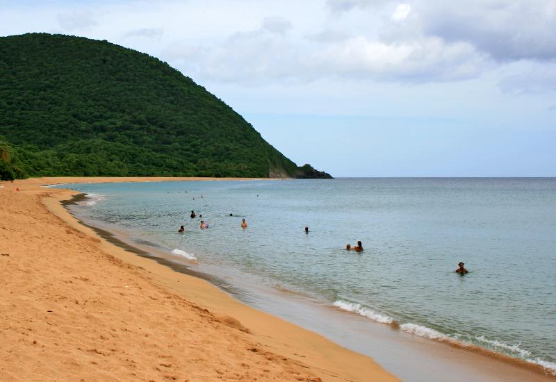
Tucked between mountain and sea, Deshaies boasts a string of beautiful beaches and coves, some of which are at the mouth of valleys bathed by rivers. The commune’s traditional economy was based on fishing, agriculture (coffee, vanilla, cacao, manioc, and cotton) and artisanal crafts. Its coastline, characterized by low bluffs, runs for a dozen kilometers. Mangrove areas feature numerous ponds, including Grand Etang (“Big Pond”), Petit Bas Vent (“Little Low Wind”), Cassis (“Currant”), Rate (“Rat”), Ziotte, and Grande Anse (“Grand Cove”). The tour begins at the island’s most ancient geological outcropping, Morne Fraîcheur (“Cool Hill”) at the border with Sainte-Rose, the commune’s northernmost point. This part of the island features vegetation typical to ocean-side bluffs, including manchineel and raisinier (“sea grape”) trees. As visitors travel south on national highway N2, the commune’s pelagic charms unfold, first at intimate Anse de Tillet beach, followed by a magnificent panorama that includes Anse du Grand Bas Vent (“Big Low-Wind Cove”), the Caribbean Sea, and Pointe du Petit Bas-Vent (“Little Low-Wind Point”), where the tourist hotel built on the site of the former Fort Royal proudly stands. The road then begins to climb inland to the heights, offering a panoramic view of Kahouanne islet. In clear weather, Monserrat Island can be seen on the horizon.
Pass two small residential areas scattered across their coves of the same name: La Perle (“Pearl”) and Rifflet. An alluring setting of red sand and emerald sea, Pearl Beach lives up to its name. This is the starting point for the coastal trail that leads southward to Gros Morne (“Big Hill”). Walk among xerophilous forest species such acomat (“buttress root”) and ebony trees, orchids, and cacti. Royal terns and brown pelicans perch on the reefs. Visitors are likely to encounter fishermen, farmers, and wood craftsmen during the hike.
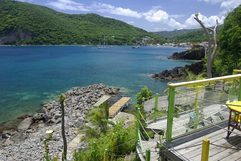
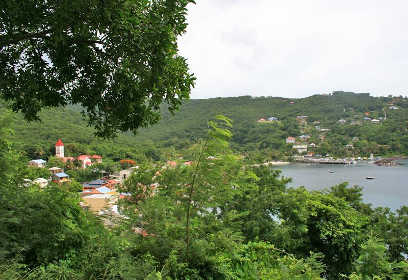
The small seaside village of Rifflet carries on the island’s manioc tradition, and those in the know never miss the Sunday cassava tasting. Highway N 2 follows the coast past Le Breton Point. Enjoy the exceptional overlook at the foot of Morne Gadet, with Grande Anse, one of the island’s finest beaches, stretching out below. Houses to the north indicate the Ziotte Quarter. Take departmental highway D18 to the Caféière (“Coffee Plantation”) sector, then follow a road leading to the right in the direction of Montagne aux Orchidées (“Orchid Mountain”). One kilometer up, a stela marks the location of the 1962 crash of a Boeing jet. A trail of the same name (“Trace du Boeing”) starts here. Return to highway N2 and continue south in the shadow of Gros Morne (“Big Hill”), a peninsula rising to an elevation of 206 meters (footpath available), before reaching the village of Deshaies. Tucked into its cove between Gros Morne and Morne aux Fous (“Madman Hill”), this sheltered harbor is a landing for cruise ships, with a picturesque village of lively streets and Creole houses nestled between sea and forest that welcomes visitors with open arms. Stroll through the town at its quiet pace to discover vestiges of its history and heritage: Saint-Pierre and Saint-Paul Church, symbol of unity for local residents; the fascinating megalith sculpture entitled “The Observer” in front of the library; the Némorin family bread oven, which dates from the 1940s; the Pont Rouge (“Red Bridge”); boutiques; and, of course, the port. This calm and sheltered port serves as a supply point for all seafarers, and provides anchorage for fishing dinghies, sea-fishing boats, and pleasure boats. Gorgeous sunsets guaranteed. From the port, Battery Point can be seen, a former strategic defense, with cannons and powder magazine (footpath available). Next, continue toward Pointe-Noire. In Viller, visit the botanical garden, with its magnificent flowers and animal park. Along the road, a marble marker bears the inscription “Côte-sous-le-vent reconnaissante” (“In gratitude, Côte-sous-le-vent”), commemorating 1957, the year when the national highway was finally completed between Deshaies and Pointe-Noire. Explore the Deshaies heights on a small mountain road leading to Morne Bois d’Inde (“Indian Bay Tree Hill”) and Morne Mazeau, with unique panoramas of the coast, Caribbean Sea, and, in the distance, Montserrat Island and its 915-meter volcano. This is the starting point for trails leading to Barre de l’île, Sofaïa, Solitude, and Dos d’Ane, among others. On the ocean side, visit small, untouched Paul Thomas beach, a haven of tranquility. After that, visit Ferry, known for the skill of its seine-net fishermen and boat builders. The hamlet of Ferry features Leroux Beach, at the foot of Ferry Point; a former battery; and a footpath, in addition to a well-equipped water sports center. Lovely Petite Anse Beach marks the boundary between the communes of Deshaies and Pointe-Noire. Chemin Bleu tourist maps of Guadeloupe and city street maps are available at the Office of Tourism. www.villededeshaies.fr.


-
Sightseeing

- South Basse-Terre: Thrilling Sensations in a Tropical Forest Setting
- Côte-sous-le-vent: Artisanal Craftsmanship and Spectacular Diving
- North Basse-Terre: Glimmers of Sugar Cane and Marine Breezes
- North Grande-Terre: Stunning Landscapes and Cane Traditions
- East Grande-Terre: Thrilling Emotions on Land and Sea
- West Grande-Terre: Colors, Flavors, and a Glorious Past
- Les Saintes: Marine Breezes and Sweet Relaxation
- Marie-Galante: Non-Stop Charm in the Land of Sugar
- La Désirade: Untouched Landscapes, Shared Emotions
-
Tourist
-
Communes

- Les Abymes
- Anse-Bertrand
- Baie-Mahault
- Baillif
- Basse-Terre
- Bouillante
- Capesterre-Belle-Eau
- Capesterre-de-Marie-Galante
- Deshaies
- La Désirade
- Le Gosier
- Gourbeyre
- Goyave
- Grand-Bourg
- Lamentin
- Morne-à-l'Eau
- Le Moule
- Petit-Bourg
- Petit-Canal
- Pointe-à-Pitre
- Pointe-Noire
- Port-Louis
- Saint-Claude
- Sainte-Anne
- Sainte-Rose
- Saint-François
- Saint-Louis
- Terre-de-Bas
- Terre-de-Haut
- Trois-Rivières
- Vieux-Fort
- Vieux-Habitants
Downloadable
-
See all places

- “La Renaissance” movie theater - Pointe-à-Pitre
- 1st and 2nd Carbet Waterfalls - Capesterre Belle-Eau
- 3rd Carbet Waterfall - Capesterre Belle-Eau
- 5 February 1967, Square - Petit-Canal
- 9 August 1882 Square - Terre-de-Bas
- Acomat Falls - Pointe-Noire
- Acomat Point - Trois-Rivières
- Adventitious Church of Vieux-Habitants - Vieux-Habitants
- Airfield - Saint-François
- AIslands Cove - Sainte-Rose
- Alexina Garden - Le Gosier
- Allée de la Liberté - Bouillante
- Allée Dumanoir - Capesterre Belle Eau
- Allée Dumanoir Recreational Area - Capesterre Belle-Eau
- Almond Tree Beach - Sainte-Rose
- Amédée Detreaux Velodrome - Baie-Mahault
- Amédée Fengarol Primary School - Capesterre Belle-Eau
- Amerindian Garden of the Edgar Clerc Museum - Le Moule
- Amerindian Heritage - Baillif
- Ancien monastère Saint-Antoine - Basse-Terre
- Anse à Sable Beach - Bouillante
- Anse Colas - Anse-Bertrand
- Anse Crawen - Terre-de-Haut
- Anse de Pigeon - Bouillante
- Anse du Fond Curé - Terre-de-Haut
- Anse du Souffleur beach - Port-Louis
- Anse Duché Beach - Bouillante
- Anse Dupuy - Vieux-Fort
- Anse Feuillard Cove - Capesterre de Marie-Galante
- Anse Laborde Beach - Anse-Bertrand
- Anse-Bertrand - 5 276 Hab.
- Aquaculture Park - Pointe-Noire
- Aquarium - Le Gosier
- Arboretum - Trois-Rivières
- Assainissement district - Pointe-à-Pitre
- Audoin River - Le Moule
- Babin Beach - Morne-A-l'Eau
- Back Cove - Terre-de-Bas
- Bagasse-Coal Plant - Le Moule
- Baie de Blachon - Lamentin
- Baie-Mahault - 31 069 Hab.
- Baillif - 5 801 Hab.
- Balloon Bridge - Sainte-Anne
- Banana Wood Waterfall - Lamentin
- Basse-Terre - 11 049 Hab.
- Battery Point - Deshaies
- Beach of the Other Side - Le Moule
- Beaufond Windmill - Anse-Bertrand
- Beauplaisir Windmill - Port-Louis
- Beauport Guadeloupe - Port-Louis
- Beautiran Path - Petit-Canal
- Beautiran Site - Petit-Canal
- Bébian school - Pointe-à-Pitre
- Begging Mayor Square - La Désirade
- Belin windmill - Port-Louis
- Belmont Plantation Slave Dungeon - Trois-Rivières
- Bernard Refinery - Capesterre de Marie-Galante
- Bétin plantation - Port-Louis
- Bettino Lara Media Library - Basse-Terre
- Beuthier windmill - Port-Louis
- Bézard windmill - Capesterre de Marie-Galante
- Bielle Distillery - Grand-Bourg
- Big Basin - Saint-Louis
- Big Hill - Deshaies
- Big Hole Pond - Terre-de-Bas
- Big Mouth Chasm - Saint-Louis
- Big Pond - Capesterre Belle Eau - Capesterre Belle-Eau
- Big Sand Beach - Sainte-Anne
- Bik-Kontakaz - Sainte-Anne
- Bisardy Plantation - Gourbeyre
- Bishopric - Basse-Terre
- Blackberry Bush Cove - Terre-de-Bas
- Blessed Savior Cove - Capesterre Belle-Eau
- Blondeau Plantation - Vieux-Fort
- Blonzac Aquatic Garden - Goyave
- Blower Beach - La Désirade
- Blue Pool - Gourbeyre
- Boat Cove - Saint-François
- Boat Cove - Bouillante
- Boat Cove - Vieux-Habitants
- Bois-Debout Plantation - Capesterre Belle-Eau
- Bologne Distillery - Basse-Terre
- Botanical Garden - Basse-Terre
- Botanical Garden - Deshaies
- Bouillante - 7 528 Hab.
- Bras du Fort Falls - Goyave
- Budan Windmill - Anse-Bertrand
- Bust of Augustin Gourbeyre - Gourbeyre
- Bust of Delgrès - Saint-François
- Bust of Delgrès - Deshaies
- Bust of Delgrès - Goyave
- Bust of Delgrès - Vieux-Habitants
- Bust of Félix Eboué - Pointe-à-Pitre
- Bust of Félix Eboué - Sainte-Rose
- Bust of General Frébault - Pointe-à-Pitre
- Bust of Jean Louis - Goyave
- Bust of Louis Delgrès - Pointe-Noire
- Bust of Lucien Bernier - Saint-François
- Bust of Victor Schœlcher - Morne-A-l'Eau
- Buste de Félix Eboué - Morne-A-l'Eau
- Cadoue Windmill - Anse-Bertrand
- Calvary Nature Park - Le Gosier
- Camille Soprann Square - Saint-Louis
- Camp Jacob - Saint-Claude
- Capès-Dolé Bottling Plant - Gourbeyre
- Capesterre Belle-Eau - 19 315 Hab.
- Capesterre de Marie-Galante - 3 355 Hab.
- Caraïbes Mountains - Vieux-Fort
- Caravelle Beach - Sainte-Anne
- Caravelle Surf Spot - Sainte-Anne
- Caribbean Beach - Pointe-Noire
- Caribbean Mountains - Gourbeyre
- Carmelite Square - Basse-Terre
- Carved Rock Archeological Park - Trois-Rivières
- Casino de Saint-François - Saint-François
- Cassava Factory - Sainte-Anne
- Cassava Factory - Petit-Bourg
- Cayenne Cemetery - Saint-François
- Cemetery - Morne-A-l'Eau
- Cemetery - Pointe-à-Pitre
- Cemetery Square - Le Moule
- Center for Embroidery and Textile Arts - Vieux-Fort
- Central Covered Market - Basse-Terre
- Central Market - Pointe-à-Pitre
- Champ d’Arbaud Parade Grounds - Basse-Terre
- Changy Hindu Temple - Capesterre Belle-Eau
- Chapel Beach - Anse-Bertrand
- Chapel Our Lady of Charity - Le Moule
- Chapelle Notre Dame de Guadeloupe - Saint-Claude
- Chapelle Notre Dame du Phare - La Désirade
- Chapelles - Port-Louis
- Chapp House - Basse-Terre
- Chevalier de Saint-Georges Square - Basse-Terre
- Christ the King Church at Les Mangles - Petit-Canal
- Church of Notre Dame du Bon Port - Petit-Bourg
- Church of Our Lady of Good Help - Port-Louis
- Church of Saint Phillip and Saint John - Petit-Canal
- Church of Saint-Louis - Bouillante
- Church of Sainte-Anne - Goyave
- Church of Sainte-Thérèse de l'Enfant Jésus - Petit-Bourg
- Church of St. John the Baptist - Le Moule
- Church of St. John the Baptist - Baie-Mahault
- Church of St. Peter and St. Paul - Deshaies
- Church of the Immaculate Conception - Les Abymes
- Church of the Immaculate Conception - Grand-Bourg
- Church Square - Saint-François
- Church Square - Saint-Louis
- Cicéron Alley - Basse-Terre
- Cimetière des Indiens - Saint-François
- Ciné-Théâtre - Lamentin
- City Hall - Les Abymes
- City Hall - Basse-Terre
- City Hall - Vieux-Habitants
- City Pavilion - Pointe-à-Pitre
- Claire Fontaine Plantation - Baillif
- Cliff Trace - Anse-Bertrand
- Cliffs - Vieux-Fort
- Cluny Beach - Sainte-Rose
- Cœur de Bouillante - Bouillante
- Coffee Museum - Vieux-Habitants
- Colo Pool - Petit-Bourg
- Colonial House - Le Moule
- Column and Bust of Marianne - Bouillante
- Commemorative plaque in homage to Justin Catayée - Pointe-à-Pitre
- Courthouse - Basse-Terre
- Crab House - Le Moule
- Crawfish Cascade - Petit-Bourg
- Crazy Cove Beach - Grand-Bourg
- Damencourt Nature Park - Le Moule
- Damoiseau Distillery - Le Moule
- Dampierre windmill - Le Gosier
- Datcha Beach - Le Gosier
- Delgrès Stele - Morne-A-l'Eau
- Departmental Residence - Le Gosier
- Descamps House, Birmingham Plantation - Baie-Mahault
- Deshaies - 4 215 Hab.
- Deshaies Cove - Deshaies
- Deshaies Diving - Deshaies
- Desmarais Distillery - Saint-Claude
- Dévarieux windmill - Petit-Canal
- Deville-Maisoncelle Path - Petit-Canal
- Diavet and Bwé ponds - Le Gosier
- Distillerie Bellevue - Capesterre de Marie-Galante
- Diving - Bouillante
- Dolé Public Pool - Gourbeyre
- Domaine de la Lise - Bouillante
- Domaine de St-Paul - Sainte-Anne
- Du Mont Cove - Le Gosier
- Duval Site - Petit-Canal
- Eco-museum of Guadeloupe - Sainte-Rose
- Eco-Touristic Park of Trois-Pointes - Vieux-Fort
- Edgar Clerc Museum - Le Moule
- Eiffel Bridge - Pointe-Noire
- Eiffel-style Bridges - Goyave - Goyave
- Eloi Germain Interpretive Garden - Terre-de-Bas
- Escape Hill - Sainte-Anne
- Escaped Slave Memorial - Sainte-Anne
- Espace Thermo-Ludique René Toribio - Lamentin
- Espace Wizosky - Le Moule
- Fanfan Beach - La Désirade
- Father Labat Tower - Baillif
- Fatima Chapel - Le Moule
- Félix Eboué Square - Capesterre de Marie-Galante
- Ferry Battery - Deshaies
- Ferry Cove - Deshaies
- Feuillère Beach - Capesterre de Marie-Galante
- Fidelin Pond - Les Abymes
- Fiesque Duchesne Stadium - Baie-Mahault
- Fifi Beach - La Désirade
- Fig Tree Beach - Terre-de-Haut
- Fishing and Pleasure Boat Port - Sainte-Rose
- Fishing and Pleasure Boat Port - Sainte-Rose
- Fishing Port - Saint-François
- Fishing Port - Le Moule
- Fishing Port - Deshaies
- Folle-Anse Cargo Port - Grand-Bourg
- Fontaine Adolphine - Saint-Claude
- Footbridge of the Two Banks - Le Moule
- Former Cotton Mill - La Désirade
- Former Dorot Distillery - Saint-Louis
- Former Duval Refinery - Petit-Canal
- Former Fidelin Pottery Works - Terre-de-Bas
- Former Grosse Montagne Sugar Plant - Lamentin
- Former health care center and maternity hospital - Port-Louis
- Former Law Courts - Port-Louis
- Former Leper Colony - La Désirade
- Former Marquisat Factory - Capesterre Belle-Eau
- Former Power Plant: La Friche - Baie-Mahault
- Former Prison - Petit-Canal
- Former Prison - Goyave
- Former Prison - Anse-Bertrand
- Former Rex movie theater - Port-Louis - Port Louis
- Former Saint-Jacques plantation - Saint-François
- Former Weather Station - La Désirade
- Fort Fleur d'Epée - Le Gosier
- Fort l'Olive - Vieux-Fort
- Fort Louis - Le Gosier
- Fort Louis Delgrès - Basse-Terre
- Fort Napoleon - Terre-de-Haut
- Fortune Islet - Goyave
- Fountain - Gourbeyre
- Fresque murale du lycée de Baimbridge - Les Abymes
- Gadet Lookout - Deshaies
- Galion Falls - Saint-Claude
- Galion Gorges - Saint-Claude
- Gardel Factory - Le Moule
- Gaschet Ravine - Petit-Canal
- Gates of Hell - Le Moule
- Gates of Hell - Anse-Bertrand
- Gédéon-Bambou park - Morne-A-L'Eau
- General Council Building - Basse-Terre
- Gertrude Square - Petit-Bourg
- Gerty Archimède Museum - Basse-Terre
- Gerville-Réache Secondary School - Basse-Terre
- Getz Plantation - Vieux-Habitants
- Gilles Floro Culture House - Gourbeyre
- Girard windmill - Petit-Canal
- Giratoire “Les amarreuses de Jabrun” - Baie-Mahault
- Gissac windmill - Sainte-Anne
- Godet windmill - Petit-Canal
- Good Mother Factory - Sainte-Rose
- Gourbeyre - 7 986 Hab.
- Gourd Cove Beach - Saint-François
- Goyave - 7 761 Hab.
- Grand Cove Beach - Deshaies
- Grand Cul-de-Sac Marin Bay - Sainte-Rose
- Grand Cul-de-Sac Marin Natural Preserve - Baie-Mahault
- Grand Pierre windmill - Saint-Louis
- Grand-Anse Beach - Terre-de-Bas
- Grand-Bourg - 5 409 Hab.
- Grand-Bourg Beach - Grand-Bourg
- Grand-Point Battery - Trois-Rivières
- Grande Anse Sugar Refinery - Grand-Bourg
- Grande Rivière à Goyaves - Lamentin
- Grande Vigie Point - Anse-Bertrand
- Grande-Anse Battery - Trois-Rivières
- Grandfond Windmill - Anse-Bertrand
- Grands Fonds - Le Gosier
- Grands Fonds - Sainte-Anne
- Grands Fonds - Le Moule
- Grands Fonds - Les Abymes
- Great Cove Beach - Trois-Rivières
- Greenery Point - Le Gosier
- Guyonneau Plantation - Deshaies
- Habitation Desmarets - Basse-Terre
- Habitation La Mahaudière - Anse-Bertrand
- Harbor Terminal - Saint-François
- Helleux Surf Spot - Sainte-Anne
- Henry Sidambarom Stela - Capesterre Belle-Eau
- Heritage House - Basse-Terre
- Hiking Trails - Gourbeyre
- Hiking Trails - La Désirade
- Hiking Trails - Terre-de-Bas
- Hiking Trails - Pointe-Noire
- Hindu temple - Les Abymes
- Hindu Temple of Gaschet - Port-Louis
- Hot baths of Matouba - Saint-Claude
- House of Bananas - Trois-Rivières
- House of Cacao - Pointe-Noire
- House of the Elders - Basse-Terre
- Hummingbird Point - La Désirade
- Ilet Boissard - Pointe-à-Pitre
- Ilet Caret - Sainte-Rose
- Ilets de Carénage, Ilet Blanc, Ilet la Biche - Sainte-Rose
- Indian Memorial - Saint-François
- Information Office and Bust of Louis Delgrès - Gourbeyre
- International Golf Course - Saint-François
- Isle of the Goats - Terre-de-Haut
- Jardin de la Rencontre - Capesterre Belle-Eau
- Jérôme Cléry Municipal Auditorium - Basse-Terre
- Jolan Woods Beach - Sainte-Anne
- Karukera Rum Distillery - Capesterre Belle-Eau
- Karuptures – Totem, Work of Edgar Negret - Lamentin
- Karuptures, Lumi-Naissance - Lamentin
- Karuptures, Madonna and Child, work of Leopoldo Maler - Lamentin
- Karuptures, Physiochromie du Lamentin, work of Carlos Cruz Diez. - Lamentin
- Karuptures, Tribute to the abolition of human slavery, work of Erik Dietman - Lamentin
- Kreol West Indies - Grand-Bourg
- Kreol West Indies Museum Space - Saint-François
- L’Herminier House - Pointe-à-Pitre
- L’il Cove Beach - Pointe-Noire
- La Coulisse - Trois-Rivières
- La Darse - Pointe-à-Pitre
- La Désirade - 1 549 Hab.
- La Grivelière Plantation - Vieux-Habitants
- La Lézarde Falls - Petit-Bourg
- La Lézarde River - Petit-Bourg
- La Mahaudière Windmill - Anse-Bertrand
- La Marianne - Pointe-Noire
- La Pastorale House - Trois-Rivières
- La Ramée Plantation - Sainte-Rose
- La Rose Plantation - Goyave
- Ladder Cove - La Désirade
- Lagoon Beach - Saint-François
- Lake Gaschet - Port-Louis
- Lamentin - 16 313 Hab.
- Latchmansing temple - Shiva temple - Saint-François
- Laura Flessel Sports Complex - Petit-Bourg
- Le Chameau - Terre-de-Haut
- Le Gosier - 27 920 Hab.
- Le Gosier Islet - Le Gosier
- Le Moule - 22 404 Hab.
- Leeward Coast House - Vieux-Habitants
- Leroux Beach - Deshaies
- Les Abymes - 56 581 Hab.
- Letaye Dam - Le Moule
- Lethière Street - Sainte-Anne
- Lethière Traffic Circle - Sainte-Anne
- Liberty Square - Basse-Terre
- Lighthouse - Vieux-Fort
- Little Cove Beach - Capesterre de Marie-Galante
- Little River Beach - La Désirade
- Loiseau Plantation - Vieux-Habitants
- Louis Delgrès Stela - Saint-Claude
- Lovers’ Pool - Gourbeyre
- Lubeth windmilll - Petit-Canal
- Lycée Carnot - Pointe-à-Pitre
- Maison de la Forêt - Petit-Bourg
- Maison de la Mangrove - Les Abymes
- Maison Monnerville - Morne-A-l'Eau
- Maisons typiques - Anse-Bertrand
- Malendure Beach - Bouillante
- Mambia beach - Sainte-Rose
- Mamelles Zoological Park - Bouillante
- Man Réaux Mall - Pointe-à-Pitre
- Mangrove Swamp - Le Gosier
- Mangrove Swamps - Petit-Canal
- Mangrove Swamps - Saint-Louis
- Mangrove-la Ka - Port-Louis
- Manioc Factory - Deshaies
- Marigot Bay - Terre-de-Haut
- Marina - Saint-François
- Marina - Le Gosier
- Marina - Pointe-à-Pitre
- Marina traffic circle - Pointe-à-Pitre
- Marius Chipotel Square - Sainte-Anne
- Market - Sainte-Anne
- Market - Capesterre Belle-Eau
- Marquisat de Sainte-Marie Estate - Capesterre Belle-eau
- Marshes - Port-Louis
- Massabielle church - Pointe-à-Pitre
- Massif de la Madeleine - Trois-Rivières
- Matouba Factory - Saint-Claude
- Matouba Falls - Saint-Claude
- Maurice Cove - Petit-Canal
- Max Mathurin Stela - La Désirade
- Mayoumbé windmill - Saint-Louis
- Mays Cove - Saint-Louis
- Médiathèque Ernest J. Pépin - Lamentin
- Mémorial ACTe - Pointe-à-Pitre
- Mémorial aux victimes de 1925 - Petit-Canal
- Memorial to the First Day - Pointe-à-Pitre
- Memorial to the Sacrifice of Delgrès - Les Abymes
- Memorial to the victims of May 1967 - Pointe-à-Pitre
- Memorial to Victor Schoelcher - Vieux-Habitants
- Mémorial Victor Schœlcher - La Désirade
- Memorial Wall - Les Abymes
- Ménard windmill - Saint-Louis
- Michaux windmill - Petit-Canal
- Mills - Saint-François
- Moko Bridge - Lamentin
- Moko Bridge - Sainte-Rose
- Montal Beach - Le Moule
- Montebello Distillery - Petit-Bourg
- Monument aux morts - Anse-Bertrand
- Monument aux morts (“War Memorial”) - Lamentin
- Monument of the Eternal Flame to the Unknown Slave - Petit-Canal
- Monument to Christopher Columbus - Capesterre Belle-Eau
- Monument to Freedom - Petit-Canal
- Moreau Falls - Goyave
- Moreau Interpretive Trail - Goyave
- Morel Trace - Terre-de-Haut
- Morne Calvaire - Les Abymes
- Morne de la Mémoire - Les Abymes
- Morne-à-l'Eau - 17 504 Hab.
- Morne-Rouge School - Sainte-Rose
- Murat Plantation and Eco-Museum of Marie-Galante - Grand-Bourg
- Musée de la graine - Trois-Rivières
- Museum of Costumes and Traditions - Le Gosier
- Museum of Days Gone By - Petit-Canal
- National Theater - Basse-Terre
- Nature Park - Petit Canal
- Neg Mawon Stela - Petit-Bourg
- Néron Plantation - Le Moule
- Night Market - Saint-François
- Night Market - Sainte-Anne
- Night Market - Petit-Bourg
- Notre Dame du Mont-Carmel Church - Basse-Terre
- Notre Dame Sanctuary - Deshaies
- Notre-Dame de Guadeloupe Cathedral - Basse-Terre
- Novilos Courtyard - Basse-Terre
- Nozières Bridge - Saint-Claude
- Oceanfront - Basse-Terre
- Old Mill Trace - Petit-Canal
- Old Town Hall - Saint-Claude
- Olive Bay - Saint-François
- Olympe Victor Auguste Combes Giratoire - Lamentin
- Open-Air Theater - Lamentin
- Oratory - Goyave
- Ornithological site of Ravine Sable - Anse-Bertrand
- Osange Talis Gane Multimedia Library - Sainte-Anne
- Ouatibi Tibi Park - Le Moule
- Our Lady of Calvary Chapel - La Désirade
- Our Lady of Good Help Church - La Désirade
- Our Lady of Good Hope - Morne-A-l'Eau
- Our Lady of Jarry Chapel - Baie-Mahault
- Our Lady of the Assumption Church - Terre-de-Haut
- Our Lady of the Assumption Church - Pointe-Noire
- Our Lady of the Assumption Church - Trois-Rivières
- Palace of Culture Felix Proto - Les Abymes
- Palais d'Orléans (Prefecture Building) - Basse-Terre
- Paradise Pool - Capesterre Belle-Eau
- Paradoxe Croisières - Saint-François
- Parc de la Source - Bouillante
- Parc de la Verdure - Lamentin
- Parc National - Saint-Claude
- Paul Aubin windmill - Port-Louis
- Paul Lacavé Memorial - Capesterre Belle-Eau
- Paul Mado Multimedia Library - Baie-Mahault
- Paved Path Ravine - Le Gosier
- Pearl Beach - Deshaies
- Pebble Beach - La Désirade
- Pebble Cove - La Désirade
- Perrin Canal - Les Abymes
- Petit Carbet Plantation-Refinery - Trois-Rivières
- Petit Cul-de-Sac Marin - Petit-Bourg
- Petit-Bourg - 24 507 Hab.
- Petit-Canal - 8 262 Hab.
- Petit-Havre Beach - Le Gosier
- Petite Anse Cove - Terre-de-Bas
- Petite Terre - La Désirade
- Petite-Anse beach - Bouillante
- Pichon Square - Basse-Terre
- Pigeon Isles - Bouillante
- Place Camille Desmoulins - Pointe-à-Pitre
- Place de la Mairie - Bouillante
- Place de la Victoire - Pointe-à-Pitre
- Place Frédéric Jalton - Les Abymes
- Place Gerty Archimède - Morne-A-l'Eau
- Place Gourbeyre - Pointe-à-Pitre
- Plage de Grande-Anse - Terre-de-Haut
- Plage de l'Anse Canot - Saint-Louis
- Plage de la Porte d'Enfer - Anse-Bertrand
- Plage de Moustique - Saint-Louis
- Plaine de Grippon - Morne-A-l'Eau
- Plaisance windmill - Port-Louis
- Plantation Grand Café - Capesterre Belle-Eau
- Plate Point Trail - Anse-Bertrand
- Plateau du Palmiste - Gourbeyre
- Platform of Beron (Bonne Mère) - Sainte-Rose
- Point Bleu Soleil - Gourbeyre
- Point Helleux Beach - Sainte-Anne
- Pointe Allègre - Sainte-Rose
- Pointe des Châteaux - Saint-François
- Pointe-à-Pitre - 16 427 Hab.
- Pointe-Noire - 6 519 Hab.
- Poisson Distillery - Grand-Bourg
- Pôle Caraïbes Airport - Les Abymes
- Polishing block of Dindé - Sainte-Rose
- Pompierre Beach - Terre-de-Haut
- Pond Beach - Vieux-Habitants
- Pond Trace Hiking Trail - Capesterre Belle-Eau
- Ponds - Anse-Bertrand
- Pont de la rivière du Plessis - Baillif
- Port - Petit-Canal
- Port - Port-Louis
- Port - La Désirade
- Port - Capesterre de Marie-Galante
- Port - Grand-Bourg
- Port - Saint-Louis
- Port - Baie-Mahault
- Port de Vieux-Bourg - Morne-A-l'Eau
- Port Galbas - Sainte-Anne
- Port of Jarry - Baie-Mahault
- Port-Louis - 5 867 Hab.
- Pottery Kiln - Trois-Rivières
- Poyen windmill - Petit-Canal
- Presbytery - Port-Louis
- Primary School “Alice Delacroix“ - Petit Canal
- Public Park and Fountain - Trois-Rivières
- Pulling bull contests - Anse-Bertrand
- Pulling bull contests - district of Guéry - Anse-Bertrand
- Pulling Bulls - Baie-Mahault
- Punch Pond and Pirogue Factory - Grand-Bourg
- Rambouillet Cross - Port-Louis
- Raoul Georges Nicolo Media Library - Le Gosier
- Ravine Sable (Sand Ravine) - Anse-Bertrand
- Red Bridge - Deshaies
- Red Head - Terre-de-Haut
- Regional Council of Guadeloupe - Basse-Terre
- Rémy Nainsouta Center - Pointe-à-Pitre
- René Boisneuf Multimedia Library - Pointe-à-Pitre
- Réserve Cousteau - Bouillante
- Rifflet Beach - Deshaies
- Ring of Slavery - Pointe-à-Pitre
- Rivière de la Coulisse - Trois-Rivières
- Rocroy Beach - Vieux-Habitants
- Rodriguez Cove - Terre-de-Haut
- Rooster Cove - Saint-Louis
- Roseau Beach - Capesterre Belle-Eau
- Rotours Canal - Morne-A-l'Eau
- Roussel-Trianon Sugar Planation - Grand-Bourg
- Rue Achille-René Boisneuf - Pointe-à-Pitre
- Rue Frébault - Pointe-à-Pitre
- Rum Museum - Sainte-Rose
- Sailing Center - Goyave
- Saint Anne Church - Capesterre de Marie-Galante
- Saint Bernadette Church of Grands Fonds - Sainte-Anne
- Saint Denis Church - Anse-Bertrand
- Saint Dominic Church - Baillif
- Saint Hyacinth Church - Capesterre Belle-Eau
- Saint Rose of Lima Church - Sainte-Rose
- Saint-Albert Church - Vieux-Fort
- Saint-André church - Morne-A-l'Eau
- Saint-Augustin Church - Saint-Claude
- Saint-Charles Borromée Church - Gourbeyre
- Saint-Claude - 10 587 Hab.
- Saint-Felix Beach - Le Gosier
- Saint-François - 14 609 Hab.
- Saint-Jacques Racetrack - Anse-Bertrand
- Saint-John Perse Museum - Pointe-à-Pitre
- Saint-Joseph Church - Vieux-Habitants
- Saint-Joseph de Cluny Day School - Pointe-à-Pitre
- Saint-Louis - 2 540 Hab.
- Saint-Louis Beach - Saint-Louis
- Saint-Louis Church - Le Gosier
- Saint-Louis Plantation - Baillif
- Saint-Nicolas Church - Terre-de-Bas
- Saint-Pierre and Saint-Paul church - Pointe-à-Pitre
- Sainte-Anne - 25 037 Hab.
- Sainte-Anne Church - Sainte-Anne
- Sainte-Claire Beach - Goyave
- Sainte-Rose - Sainte-Rose
- Sainte-Trinité Church - Lamentin
- Saintes Bay - Terre-de-Haut
- Salabouelle Cove - Le Moule
- Saline Beach - Le Gosier
- Saltwork Beach - Le Gosier
- Salty Cove - Capesterre Belle-Eau
- Sans Fenêtre Windmill - Anse-Bertrand
- Sarrault Square - Petit-Bourg
- Schœlcher Museum - Pointe-à-Pitre
- Schœlcher Square - Sainte-Anne
- Sé la vi la ki pli bèl (“Life is Beautiful”) Sculpture - Basse-Terre
- Seashore - Pointe-Noire
- Seaside cemetery - Port-Louis
- Sens River Beach - Gourbeyre
- Sens River Marina - Gourbeyre
- Sentier de l'Acomat - Trois-Rivières
- Sentier Lavolvaine - Port-Louis
- Séo Pond - Sainte-Anne
- Séverin Estate - Sainte-Rose
- Shell House - Basse-Terre
- Shoreline Trail - Le Gosier
- Shrine of Our Lady of Tears - Pointe-Noire
- Silver Basin Port - Pointe-Noire
- Simaho Beach - Vieux-Habitants
- Simonière pond - Saint-François
- Site of the 1962 Boeing Jet Crash - Deshaies
- Slave Cemetery - Capesterre Belle-eau
- Slave Memorial - Saint-François
- Slave Steps - Petit-Canal
- Small Fort - Le Moule
- Social Hall - Lamentin
- Sofaïa Sulfur Springs - Sainte-Rose
- Sonis Cultural Center - Les Abymes
- Source de Poucet - Le Gosier
- Source de Thomas - Bouillante
- Source of the Rivière Rouge - Saint-Claude
- Sports Center - Le Gosier
- Spot de Damencourt - Le Moule
- Spot de La Bouelle - Le Moule
- Spot de La Chapelle - Anse-Bertrand
- Spot de La Station - Le Moule
- Square Christophe Colomb (Christopher Columbus Square) - Baie-Mahault
- Square Guy Cornély - Les Abymes
- Statue of Gandhi - Saint-François
- Statue of Joseph Ignace - Les Abymes
- Statue of Martin Luther King - Saint-François
- Statue of Nelson Mandela - Les Abymes
- Statue of the mulatto woman, “Solitude” - Les Abymes
- Statue of Vélo, the King of ka - Pointe-à-Pitre
- Sucrerie de Nogent - Sainte-Rose
- Sugar Cane Tradition - Baie-Mahault
- Sugar Loaf Mountain - Terre-de-Haut
- Sylvathèque - Gourbeyre
- Tabarin Cove Beach - Le Gosier
- Taliseronde Beach - Capesterre de Marie-Galante
- Tarare Cove - Saint-François
- Teddy Riner Square - Vieux-Habitants
- Terre-de-Bas - 1 097 Hab.
- Terre-de-Haut - 1 699 Hab.
- The Carénage district - Pointe-à-Pitre
- The district of “Grand-Baie“ - Le Gosier
- The Former Arsenal - Basse-Terre
- The former City Hall - Les Abymes
- The former Darboussier factory - Pointe-à-Pitre
- The former factory in Blanchet - Morne-à-l'Eau
- The former factory in Pointe-à-Retz - Morne à l'Eau
- The Galleries - Capesterre de Marie-Galante
- The Geothermal Plant - Bouillante
- The Law Courts - Pointe-à-Pitre
- The Mutual Insurance Building - Pointe-à-Pitre
- The New Courthouse - Pointe-à-Pitre
- The Observer - Deshaies
- The Old Municipal Jail - Bouillante
- The Old Town Hall - Bouillante
- The Pointe des Châteaux Cross - Saint-François
- The Port - Petit-Bourg
- The Port - Goyave
- The Rotunda - Saint-François
- The Sulfurer Volcano - Saint-Claude
- Three Bridges - Sainte-Anne
- Three Islands Beach - Grand-Bourg
- Three-Horn Falls - Sainte-Rose
- Tillet Beach - Deshaies
- Tourist House - Saint-Claude
- Town Beach - Sainte-Anne
- Town Hall - Sainte-Anne
- Town Hall - Morne-A-l'Eau
- Town Hall - Port-Louis
- Town Hall - Grand-Bourg
- Town Hall - Capesterre de Marie-Galante
- Town Hall - Petit-Bourg
- Town Hall - Sainte-Rose
- Town Hall - Lamentin
- Town Hall - Pointe-Noire
- Town Hall - Capesterre Belle-Eau
- Town Hall - Trois-Rivières
- Town Hall - Baillif
- Town Hall - Saint-Claude
- Town Hall - Baie-Mahault
- Town Hall - Petit-Canal
- Town Hall Square - Terre-de-Haut
- Town Hall Square - Petit-Bourg
- Tradewinds Beach - Le Moule
- Traditional Houses - Petit-Bourg
- Traditional Houses - Pointe-Noire
- Traditional Houses - Basse-Terre
- Trois-Rivières - 8 625 Hab.
- Typical houses - Port-Louis
- Typical houses - Pointe-à-Pitre
- Typical houses - Morne-à-l'Eau - Morne à l'Eau
- Valombreuse Gardens - Petit-Bourg
- Vanibel Estate - Vieux-Habitants
- Vernou Residential Quarter - Petit-Bourg
- Viard Beach - Petit-Bourg
- Viard River - Sainte-Rose
- Victor Schœlcher Column - Anse-Bertrand
- Victor Schœlcher Square - Grand-Bourg
- Victor Servan Soliman Nature Park - Petit-Bourg
- Vieux-Bourg church - Morne-A-l'Eau
- Vieux-Fort - 1 897 Hab.
- Vieux-Fort Beach - Saint-Louis
- Vieux-Habitants - 7 602 Hab.
- Volcanology and Seismology Laboratory - Gourbeyre
- Walking and Hiking - Bouillante
- War Memorial - Sainte-Anne
- War Memorial - Petit-Canal
- War Memorial - Port-Louis
- War memorial - Pointe-à-Pitre
- War Memorial - Les Abymes
- War Memorial - Saint-Louis
- War Memorial - Baie-Mahault
- War Memorial - Petit-Bourg
- War Memorial - Pointe-Noire
- War Memorial - Capesterre Belle-Eau
- War Memorial - Vieux-Habitants
- Water Cove - Saint-François
- Water Sports Center - Saint-François
- Water Sports Center - Sainte-Anne
- Water Sports Center - Sainte-Rose
- Waterfront - Sainte-Anne
- Waterfront - Baie-Mahault
- Waterfront Boulevard - Le Moule
- Wharf - Trois-Rivières
- White Grape Beach - Saint-François
- White Water Bridge - Le Moule
- Wind Farms - Capesterre de Marie-Galante
- Wind Turbines - La Désirade
- Wind Turbines - Terre-de-Bas
- Wonche Colonial House - Baie-Mahault
- World Trade Center Complex - Baie-Mahault
- Yellow Baths - Saint-Claude

-
See all businesses

- A2L Parapente Guadeloupe - Air - Le Moule
- Aérodrome de Saint-François - Air - Saint-François
- Aéroport Pôle Caraïbes - Air - Les Abymes
- Air Guadeloupe - Paragliding flight - Le Moule
- Alizé Plongée - Nautical - Bouillante
- Alizés Vacances - Apartment - Le Moule
- Anny Location - Car - Deshaies
- Anny Location - Car - Pointe-Noire
- Anse Auto Services - Car - Anse-Bertrand
- Archipel (Comadile) - Sea - Saint-Francois
- Archipel (Comadile) - Sea - La Désirade
- Atmosphère - Water Sports - Sainte-Anne
- Atmosphère - Water Sports - Sainte-Anne
- Atmosphère - Water Sports - Le Gosier
- Au Bon Vivre - Sea view - Terre-de-Haut
- Au Jardin des Colibris - Cottage - Deshaies
- Au Petit Grill - Sea view - Terre-de-Bas
- Auberge de la Vieille Tour - Hotel - Le Gosier
- Auberge Le Grand Large - Hotel - Sainte-Anne
- Auto Discount - Car - Saint-François
- Autolagon - car - Les Abymes
- Autolagon - Car - Petit-Canal
- Autolagon - Car - Anse-Bertrand
- Autolagon - Car - Port-Louis
- Aventure Cétacés - Excursions - Bouillante
- Beleau car - Car - Capesterre Belle-Eau
- Bellevue Gîtes - Cottage - Petit-Bourg
- Bik Kontakaz - Land - Sainte-Anne
- Burner Location - Car - Sainte-Rose
- Bwa Chic - Hotel - Saint-François
- Café de la Marine - sea view - Terre-de-Haut
- Canella Beach - Hotel - Le Gosier
- Caneval Elian - Car - Grand-Bourg
- Cap Sud Caraïbes - Hotel - Le Gosier
- Caprice des iles - Sea view - Baillif
- Capthéo2 - Two-wheeled - Terre-de-Haut
- Caraïb' Bay Hotel - Hotel - Deshaies
- Caraïbe Kayak - Kayak rental - Snorkeling - Bouillante
- Caraïbes Flyboard - Water sports - Port-Louis
- Caraïbes Gliss - Water sports - Pointe-Noire
- Carrefour Location - Car - Baie-Mahault
- Charly Excursions - Nautical excursion - Terre-de-Haut
- Chez Clara - Sea view - Sainte-Rose
- Chez Denis - Country - Gourbeyre
- Chez Gisèle & Philippe - Cottage - Terre-de-Haut
- Chez Joby Jack - Holiday cottage - Anse-Bertrand
- Choukasik - Local Product - Port-Louis
- Chris Auto - Car - Sainte-Anne
- Chris Auto - Car - Saint-François
- Claude'Car - Car - Bouillante
- Club Caravelle - Cottage - La Désirade
- Club Med - Hotel - Sainte-Anne
- Coco Beach Resort - Hotel - Grand-Bourg
- Cœur Caraïbes - Cottage - Deshaies
- Cubix Location - Car - Grand-Bourg
- Cubix Location - Saint-Louis
- Domaine de Belle Plaine - Landscape - Sainte-Rose
- Domaine de la Grande Vigie - Holiday cottage - Anse-Bertrand
- Domaine de Vanibel - Cottage - Vieux-Habitants
- Donuts BBQ Boat - Boat rental without a license - Saint-François
- Ecovolt Rent - Car - Sainte-Rose
- Ediloca - Rent a car - Vieux-Fort
- ELI Autogire - Air - Grand-Bourg
- Elite Location - Car - Bouillante
- Entre ciel et mer - Sea view - Le Gosier
- Espace Caraïbes - Holiday cottage - Anse-Bertrand
- Fanélie Location - Cottage - Deshaies
- Get Out Guadeloupe - Escape Game - Baie-Mahault
- Gina Auto - Rent a car - Pointe-à-Pitre
- Gîtes Ayonbety - Cottage - Le Moule
- Gîtes Kaladja - Cottage - Port-Louis
- Gîtes Laroseraie - Cottage - Lamentin
- Gîtes Les Colibris - Cottage - Saint-Claude
- Gîtes Pavillon - Cottage - Gourbeyre
- GPE Plongée - Sea - Bouillante
- Green Blue House - Apartment - Saint-François
- Guada Découverte - Sea - Sainte-Rose
- Guadeloupe Pêches Sportives - Water sports - Pointe-Noire
- Gwad Loc - Car - Petit-Bourg
- Gwada Drink Bike - Drink Bike - Saint-François
- Gwada Pagaie - Sea - Bouillante
- Gwadacar - Car - Sainte-Anne
- Gwadive - Water sports - Port-Louis
- Habitation du Comté - Country - Sainte-Rose
- Habitation Grande Anse - Apartments - Deshaies
- Habitation Thara - Cottage - Le Moule
- Hostellerie des Châteaux - Hotel - Saint-François
- Hôtel Clipper - Hotel - Le Gosier
- Hôtel Fleur d'Epée - Hotel - Le Gosier
- Hôtel Fort Royal - Hotel - Deshaies
- Hôtel La Maison Créole - Hotel - Le Gosier
- Hôtel Le Petit Havre - Hotel - Le Gosier
- Hôtel Résidence Le Golf Village - Hotel - Saint-François
- Hôtel Rotabas - Hotel - Sainte-Anne
- Hôtel Salako - Hotel - Le Gosier
- Hôtel St-John Perse - Hotel - Pointe-à-Pitre
- Iguana Beach (Comatrile) - Sea - Saint-François
- Iguana Beach (Comatrile) - Sea - Terre-de-Haut
- Iguana Beach (Comatrile) - Sea - Saint-Louis
- Iguana Locations - Car - Terre-de-Bas
- Iguane Café - Sea view - Saint-François
- Jardin Malanga Hôtel - Hotel - Trois-Rivières
- Jericho Gîtes et Spa - Apartment - Capesterre de Marie-Galante
- Jumbo Car - Rent à car - Les Abymes
- Jumbo Car - Rent a car - Le Gosier
- Jumbo Car - Rent a car - Baillif
- Jumbo Car - Rent a car - Gourbeyre
- Jumbo Car - Rent a car - Baie-Mahault
- Jumbo Car - Rent a car - Sainte-Anne
- Karukera Surf Club - Surf - Le Moule
- Kazanne - Cottage - Pointe-Noire
- L'Anthonis - City centre - Anse-Bertrand
- L'Océanite - Country - Saint-Louis
- La Belle Chaudière - Country - Lamentin
- La Case à Fernand - City centre - Anse-Bertrand
- La Case Créole - Town - Gourbeyre
- La Cocoteraie - Hotel - Saint-François
- La Colline Verte - Cottage - Deshaies
- La Créole Beach Hôtel & Spa - Hotel - Le Gosier
- La Dilettante - Cottage - Terre-de-Bas
- La Ferme Ti-Bou - Discovery farm - Petit-Bourg
- La Kaz à Coyoky - Cottage - Anse-Bertrand
- La Paillotte - Sea view - Terre-de-Haut
- La Payotte - Sea view - La Désirade
- La Playa - Sea view - Capesterre de Marie-Galante
- La Pointe d'Argent - Hotel - Pointe-Noire
- La Rhumerie du Pirate - Sea view - Saint-François
- La route du Rhum - Sea view - Pointe-à-Pitre
- La Toubana Hôtel & Spa - Hotel - Sainte-Anne
- La Toumbana - Country - Terre-de-Haut
- La Vallée de Guéry - Holiday cottage - Anse-Bertrand
- La Vieille Sucrerie - Cottage - Saint-Claude
- Le Banana's Plage - Sea view - Deshaies
- Le Bougainvilliers Blanc - Pointe-Noire
- Le Domaine du Rocher Noir - Cottage - Pointe-Noire
- Le Grillo - Country - Petit-Canal
- Le Jardin Tropical - Cottages - Bouillante
- Le Kontiki - Sea view - Sainte-Anne
- Le Loueur 971 - Car - Le Gosier
- Le M Hôtel de charme - Hotel - Capesterre de Marie-Galante
- Le Nautilus - Sea - Bouillante
- Le Parc aux Orchidées - Cottage - Pointe-Noire
- Le Phare - Sea view - Vieux-Fort
- Le Poisson d'Or - Sea view - Port-Louis
- Le Rayon Vert - Hotel - Deshaies
- Le Rocher de Malendure - Sea view - Bouillante
- Le Soleil Levant - Hotel - Capesterre de Marie-Galante
- Le Tam Tam - Town - Le Gosier
- Le Tapeur - Landscape - Pointe-Noire
- Le Touloulou - Sea view - Capesterre de Marie-Galante
- Le Verger de Sainte-Anne - Cottage - Sainte-Anne
- Le Vieux Port - Sea view - Saint-François
- Les Balançoires - Sea view - Terre-de-Haut
- Les Bananes Vertes - Cottage - Saint-Claude
- Les Cycas - Cottage - Saint-Claude
- Les Flots Bleus - Cottage - La Désirade
- Les Fruits de Goyave - Cottage - Goyave
- Les Gîtes de l'Union - Holiday cottage - Les Abymes
- Les Hauts de Deshaies - Cottage - Deshaies
- Les Heures Saines - Sea - Bouillante
- Les Orchidées de Sainte-Anne - Cottage - Sainte-Anne
- Les Petits Figuiers - Cottage - Terre-de-Haut
- Les Villas de Tisource - Cottage - Pointe-Noire
- Lisa Locations - Car - Capesterre Belle-Eau
- LoBleu - Hotel - Terre-de-Haut
- Locama - Car - Pointe-Noire
- Location Réflexe - Car - Baie-Mahault
- Loisirs aux Saintes - Sea - Terre-de-Haut
- Magaloc - Car - Les Abymes
- Magaloc - Car - Grand-bourg
- Magaloc - Car - Saint-Louis
- Magauto - Car - Grand-bourg
- Magauto - Car - Saint-Louis
- Majesty Palm - Apartment - Saint-François
- Majesty Palm - Sea - Saint-François
- Mawaly - Nautical excursion - Terre-de-Haut
- MG Auto - Car - Grand-Bourg
- MKG Centre Nautique - Water sports - Deshaies
- Moreau Ranch - Landscape - Goyave
- Noé Bus Tour - Land - Baie-Mahault
- O Cœur de Deshaies - Cottage - Deshaies
- Paradis Tropical - Holiday Cottage - Baillif
- Paradoxe Croisières - Sea - Saint-Francois
- Parc Aquacole - Land - Pointe-Noire
- Pharmacie Louis - Pharmacy - Le Gosier
- Pharmaciy Grand Baie - Pharmacyl - Le Gosier
- Pharmacy Allard François Nicole - Pharmacy - Pointe-à-Pitre
- Pharmacy Azar - Pharmacy - Le Moule
- Pharmacy Baie Side - Pharmacy - Petit-Bourg
- Pharmacy Bajoc Cornélie - Pharmacy - Morne-A-L'Eau
- Pharmacy Beaubois-Boucard - Pharmacy - Les Abymes
- Pharmacy Belcourt - Baie-Mahault
- Pharmacy Bernos - Pharmacy - Gourbeyre
- Pharmacy Berry - Pharmacy - Sainte-Rose
- Pharmacy Berthelot - Pharmacy - Pointe-à-Pitre
- Pharmacy Berthelot - Pharmacy - Pointe-à-Pitre
- Pharmacy Berthelot - Pharmacy - Le Moule
- Pharmacy Cap Santé - Pharmacy - Baie-Mahault
- Pharmacy Capet - Pharmacy - Les Abymes
- Pharmacy Carmentine - Pharmacy - Goyave
- Pharmacy Caruel Werter - Pharmacy - Le Gosier
- Pharmacy Cava - Pharmacy - Pointe-à-Pitre
- Pharmacy Centale - Pharmacy - Grand-Bourg
- Pharmacy Centrale - Pharmacy - Gourbeyre
- Pharmacy Copaver-Nesty - Pharmacy - Les Abymes
- Pharmacy Coudair - Pharmacy - Le Gosier
- Pharmacy Dahomay - Pharmacy - Petit-Canal
- Pharmacy de Gissac - Pharmacy - Sainte-Anne
- Pharmacy de l'Océan - Pharmacy - Sainte-Anne
- Pharmacy de la Mairie - Pharmacy - Le Moule
- Pharmacy de la Place - Pharmacy - Petit-Bourg
- Pharmacy de la Plage - Pharmacy - Capesterre de Marie-Galante
- Pharmacy de la Poste - Pharmacy - Les Abymes
- Pharmacy de La Rosière - Pharmacy - Lamentin
- Pharmacy De Losteau - Pharmacy - Bouillante
- Pharmacy de Losteau - Pharmacy - Bouillante
- Pharmacy de Pointe Bacchus - Pharmacy - Petit-Bourg
- Pharmacy de Pointe-Noire - Pharmacy - Pointe-Noire
- Pharmacy de Port-Louis - Pharmacy - Port-Louis
- Pharmacy de Rigaud - Pharmacy - Morne-A-L'Eau
- Pharmacy de Versailles Vacher-Baudin - Pharmacy - Petit-Bourg
- Pharmacy Deblaciat - Pharmacy - Les Abymes
- Pharmacy Deleplace - Pharmacy - Sainte-Rose
- Pharmacy Delta - Pharmacy - Anse-Bertrand
- Pharmacy des Isles - Pharmacy - Pointe-à-Pitre
- Pharmacy Diochot - Pharmacy - Deshaies
- Pharmacy du bourg - Pharmacy - Bouillante
- Pharmacy du C.M.B. - Pharmacy - Les Abymes
- Pharmacy du Centre - Pharmacy - Le Gosier
- Pharmacy du Fort - Pharmacy - Le Gosier
- Pharmacy du Lagon - Pharmacy - Sainte-Anne
- Pharmacy du Marché - Pharmacy - Morne-A-L'Eau
- Pharmacy du Marché - Pharmacy - Saint-François
- Pharmacy Dugamin - Pharmacy - Lamentin
- Pharmacy Eboué - Pharmacy - Petit-Bourg
- Pharmacy FDM - Pharmacy - Pointe-à-Pitre
- Pharmacy Fleur de Canne - Pharmacy - Sainte-Rose
- Pharmacy Foucan François - Pharmacy - Les Abymes
- Pharmacy Frébault - Pharmacy - Pointe-à-Pitre
- Pharmacy Gatibelza - Pharmacy - Le Gosier
- Pharmacy Girard Dugamin - Pharmacy - Lamentin
- Pharmacy Golf - Pharmacy - Saint-François
- Pharmacy Gombauld Céline - Pharmacy - Les Abymes
- Pharmacy H. Petit - Pharmacy - Le Gosier
- Pharmacy Hibiscus - Pharmacy - Les Abymes
- Pharmacy Kancel Ketty - Pharmacy - Sainte-Anne
- Pharmacy La Rose des Vents - Pharmacyp - Le Moule
- Pharmacy Leffet Théodore - Pharmacy - Lamentin
- Pharmacy Les Camélias - Pharmacy - Sainte-Anne
- Pharmacy Luce Juliette - Pharmacy - Le Moule
- Pharmacy Lydia Marcin - Pharmacy - Les Abymes
- Pharmacy Mangou - Pharmacy - Gourbeyre
- Pharmacy Médicis - Pharmacy - Goyave
- Pharmacy Mérault Raymond - Pharmacy - Les Abymes
- Pharmacy Michel Manicom - Pharmacy - Petit-Bourg
- Pharmacy Miquel - Pharmacy - Les Abymes
- Pharmacy Montout Pascal - Pharmacy - Les Abymes
- Pharmacy of Assainissement - Pharmacy - Les Abymes
- Pharmacy of Damencourt - Pharmacy - Le Moule
- Pharmacy of Gosier - Pharmacy - Le Gosier
- Pharmacy of Grand Camp - Pharmacy - Les Abymes
- Pharmacy of Kermadec - Pharmacy - Sainte-Rose
- Pharmacy of Leader - Pharmacy - Le Moule
- Pharmacy of Moudong - Pharmacy - Baie-Mahault
- Pharmacy of Pointe d’Or - Pharmacy - Les Abymes
- Pharmacy of Saint-Félix - Pharmacy - Le Gosier
- Pharmacy of the airport - Pharmacy - Les Abymes
- Pharmacy of the Cité des Métiers - Pharmacy - Les Abymes
- Pharmacy of the Licorne - Pharmacy - Saint-François
- Pharmacy of the Town Hall - Pharmacy - Baie-Mahault
- Pharmacy Perianin - Pharmacy - Les Abymes
- Pharmacy Pharmescillia - Pharmacy - Petit-Bourg
- Pharmacy Pineau Geneviève - Pharmacy - Pointe-à-Pitre
- Pharmacy Pineau Hélène - Pharmacy - Pointe-à-Pitre
- Pharmacy Pont - Pharmacy - Pointe-Noire
- Pharmacy Port Caraïbes - Pharmacy - Saint-François
- Pharmacy Renaison - Pharmacy - Basse-Terre
- Pharmacy Richeval - Pharmacy - Morne-A-L'Eau
- Pharmacy Roussel - Pharmacy - Petit-Bourg
- Pharmacy Sainte-Anne - Pharmacy - Sainte-Anne
- Pharmacy Salomon - Pharmacy - Morne-A-L'Eau
- Pharmacy Saulo - Pharmacy - Petit-Canal
- Pharmacy Sena - Pharmacy - Petit-Canal
- Pharmacy Siban - Pharmacy - Morne-àl'Eau
- Pharmacy Spartien Gilberte - Le Moule
- Pharmacy Synesius - Pharmacy - Petit-Bourg
- Pharmacy Tocny - Pharmacy - Anse-Bertrand
- Pharmacy Urgin-Bart - Pharmacy - Petit-Bourg
- Pharmacy Vila Rémi - Pharmacy - Les Abymes
- Pharmacy Weter Caruel - Pharmacy - Le Moule
- Pierre & Vacances - Hotel - Sainte-Anne
- Piton plongée - Diving - Deshaies
- Pro rent - Car - Baie-Mahault
- Racines é zel - Cottage - Vieux-Fort
- Racing Moto Cross of Merlande - Landscape - Lamentin
- Relax Boat - Self-drive boat - Bouillante
- Relax Boat - Self-drive boat - Bouillante
- Résidence Bougainvillée - Cottage - Petit-Bourg
- Résidence Madelia - Apartment - Port-Louis
- Revenge Fishing - Water sports - Deshaies
- Rochers Caraïbes - Cottage - Pointe-Noire
- Sademar - Sea - Saint-François
- Saint Germain (Comadile) - Sea - Saint-François
- Sexy Quad Evolution - Land - Lamentin
- Simonato Location - Car - Sainte-Anne
- Sogoyloc - Car - Goyave
- Sucrerie de Nogent - Cottage - Sainte-Rose
- Sucrerie de Nogent - Country - Sainte-Rose
- Sun 7 Beach - Sea view - Grand-Bourg
- The Blue Café - Country - Saint-François
- Ti Kaz La - Sea view - Terre-de-Haut
- Ti Kaz là - Sea view - Terre-de-Haut
- Ti Madras - Sea view - Anse-Bertrand
- Ti Village Créole - Sainte-Anne
- Transports Vala - Land - Terre-de-Bas
- Tropic Car - Car - Pointe-à-Pitre
- Uhaïna Croisières - Sea - Saint-François
- ULM Caraïbes - Flying over Guadeloupe - Saint-François
- Vague d'Argent - Sea view - Capesterre Belle-Eau
- Val Ferry - Sea - Pointe-à-Pitre
- Val'Ferry - Sea - Grand-Bourg
- Val'Ferry - Sea - Trois-Rivières
- Val'Ferry - Sea - Terre-de-Haut
- Vert Intense - Land - Saint-Claude
- Village Honoré - Apartment - Saint-François
- Voil'ô Saintes - Sail - Catamaran - Terre-de-Haut
- VPM Bestsail - Water sports - Le Gosier
- VV Location - car - Terre-de-Bas
- Zone Evasion Antillaise - Leisure - Les Abymes